

Size of this preview: 776 × 600 pixels. Other resolutions: 311 × 240 pixels | 621 × 480 pixels | 994 × 768 pixels | 1,280 × 989 pixels | 2,200 × 1,700 pixels.
Original file (2,200 × 1,700 pixels, file size: 289 KB, MIME type: image/jpeg)
| This is a file from the Wikimedia Commons. Information from its description page there is shown below. Commons is a freely licensed media file repository. You can help. |
Summary
| Description |
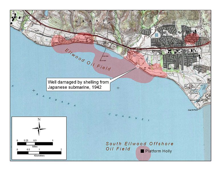
Detail map of Ellwood and Ellwood Offshore Oil Field, showing location of Luton-Bell Well No. 17, damaged by Japanese shelling 23 Feb 1942 |
| Date | |
| Source | Created in ArcGIS 9.2 using public domain sources (USGS quad map; California DOGGR database) |
| Author | User:Antandrus |
This is the location of the first attack on the mainland U.S. since the War of 1812, below Fairway 14 of the Sandpiper Golf Course, Goleta, California
Licensing
| I, the copyright holder of this work, release this work into the public domain. This applies worldwide. In some countries this may not be legally possible; if so: I grant anyone the right to use this work for any purpose, without any conditions, unless such conditions are required by law. |
File history
Click on a date/time to view the file as it appeared at that time.
| Date/Time | Thumbnail | Dimensions | User | Comment | |
|---|---|---|---|---|---|
| current | 23:38, 11 September 2008 | | 2,200 × 1,700 (289 KB) | Antandrus | {{Information |Description={{en|1=Detail map of Ellwood and Ellwood Offshore Oil Field, showing location of Luton-Bell Well No. 17, damaged by Japanese shelling 23 Feb 1942}} |Source=Created in ArcGIS 9.2 using public domain sources (USGS quad map; Califo |
File usage
The following pages on the English Wikipedia use this file (pages on other projects are not listed):
Global file usage
The following other wikis use this file:
- Usage on cs.wikipedia.org
- Usage on de.wikipedia.org
- Usage on fr.wikipedia.org
- Usage on uk.wikipedia.org
- Usage on www.wikidata.org