

Size of this JPG preview of this TIF file: 750 × 600 pixels. Other resolutions: 300 × 240 pixels | 600 × 480 pixels | 960 × 768 pixels | 1,280 × 1,024 pixels | 2,560 × 2,047 pixels | 4,944 × 3,954 pixels.
Original file (4,944 × 3,954 pixels, file size: 18.65 MB, MIME type: image/tiff)
| This is a file from the Wikimedia Commons. Information from its description page there is shown below. Commons is a freely licensed media file repository. You can help. |
| EXTERIOR, VIEW FROM NORTHEAST, CLOSE-UP - Benjamin Wade House, 22 Jefferson Street, Jefferson, Ashtabula County, OH | ||||
|---|---|---|---|---|
| Title |
EXTERIOR, VIEW FROM NORTHEAST, CLOSE-UP - Benjamin Wade House, 22 Jefferson Street, Jefferson, Ashtabula County, OH |
|||
| Depicted place | Ohio; Ashtabula County; Jefferson | |||
| Date | Documentation compiled after 1933 | |||
| Dimensions | 4 x 5 in. | |||
| Current location |
Library of Congress Prints and Photographs Division Washington, D.C. 20540 USA http://hdl.loc.gov/loc.pnp/pp.print |
|||
| Accession number |
HABS OHIO,4-JEF,3-2 |
|||
| Credit line |
|
|||
| Notes |
|
|||
| Source | https://www.loc.gov/pictures/item/oh0346.photos.127716p | |||
| Permission (Reusing this file) |
|
|||

| Object location | | View this and other nearby images on: OpenStreetMap |
|---|
File history
Click on a date/time to view the file as it appeared at that time.
| Date/Time | Thumbnail | Dimensions | User | Comment | |
|---|---|---|---|---|---|
| current | 13:15, 30 July 2014 | 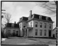 | 4,944 × 3,954 (18.65 MB) | Fæ | GWToolset: Creating mediafile for Fæ. HABS 30 July 2014 (2601:2900) |
File usage
The following pages on the English Wikipedia use this file (pages on other projects are not listed):
Global file usage
The following other wikis use this file:
- Usage on www.wikidata.org