
No higher resolution available.
Dunkeld_Bridge_-_geograph.org.uk_-_1202125.jpg (640 × 480 pixels, file size: 77 KB, MIME type: image/jpeg)
| This is a file from the Wikimedia Commons. Information from its description page there is shown below. Commons is a freely licensed media file repository. You can help. |
Summary
| Description |
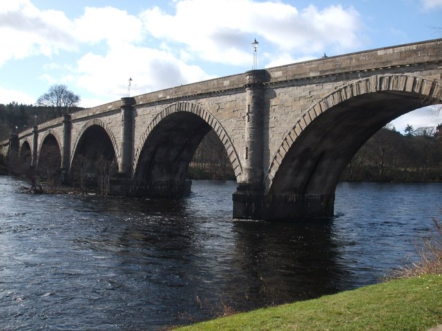
Dunkeld Bridge This elegant seven spanned bridge across the Tay was designed by Thomas Telford and opened in 1809. It is 685 feet in length, 26 1/2 feet wide and 90 feet high at the centre. Since the Duke of Atholl met part of the cost and was losing ferry dues, tolls were levied on his behalf. This was highly unpopular and over the years many riots took place. Toll gates were thrown into the river. Indeed in 1868 troops were sent to maintain order. An added annoyance was with the coming of the railway it was necessary to cross the bridge to get to the station. Eventually tolls were removed in May 1879. An added point of interest is that the landward arch was utilised as the local jail. |
| Date | |
| Source | From geograph.org.uk |
| Author | ronnie leask |
| Attribution (required by the license) | ronnie leask / Dunkeld Bridge / |
| Camera location | | View this and other nearby images on: OpenStreetMap |
|---|
_heading:180.00&language=en)
| Object location | | View this and other nearby images on: OpenStreetMap |
|---|
_heading:180.00&language=en)
Licensing

|
This image was taken from the Geograph project collection. See this photograph's page on the Geograph website for the photographer's contact details. The copyright on this image is owned by ronnie leask and is licensed for reuse under the Creative Commons Attribution-ShareAlike 2.0 license.
|
This file is licensed under the Creative Commons Attribution-Share Alike 2.0 Generic license.
Attribution: ronnie leask
- You are free:
- to share – to copy, distribute and transmit the work
- to remix – to adapt the work
- Under the following conditions:
- attribution – You must give appropriate credit, provide a link to the license, and indicate if changes were made. You may do so in any reasonable manner, but not in any way that suggests the licensor endorses you or your use.
- share alike – If you remix, transform, or build upon the material, you must distribute your contributions under the same or compatible license as the original.
File history
Click on a date/time to view the file as it appeared at that time.
| Date/Time | Thumbnail | Dimensions | User | Comment | |
|---|---|---|---|---|---|
| current | 03:14, 26 February 2011 | | 640 × 480 (77 KB) | GeographBot | == {{int:filedesc}} == {{Information |description={{en|1=Dunkeld Bridge This elegant seven spanned bridge across the Tay was designed by Thomas Telford and opened in 1809. It is 685 feet in length, 26 1/2 feet wide and 90 feet high at the centre. Since th |
File usage
The following pages on the English Wikipedia use this file (pages on other projects are not listed):
Global file usage
The following other wikis use this file:
- Usage on de.wikipedia.org