

Size of this preview: 600 × 600 pixels. Other resolutions: 240 × 240 pixels | 480 × 480 pixels | 768 × 768 pixels | 1,024 × 1,024 pixels | 2,048 × 2,048 pixels | 3,840 × 3,840 pixels.
Original file (3,840 × 3,840 pixels, file size: 1.45 MB, MIME type: image/png)
| This is a file from the Wikimedia Commons. Information from its description page there is shown below. Commons is a freely licensed media file repository. You can help. |
This file supersedes the file Khyber Pakhtunkhwa, KPK, Map.png. It is recommended to use this file rather than the other one. Reason why to use this file over the other file: "More up-to-date map and fixed borders."
|

|
Summary
| Description |
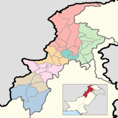
This is a map showing each and every district of Khyber Pakhtunkhwa. The map is accurate as of September 30, 2020 and has been made using data from the Pakistan Bureau of Statistics and UN OCHA's HumData Database (which citypopulation.de uses). Each color depicts a different administrative division (higher than a district but lower than a province).
A category full of these maps listed nicely can be found here. |
| Date | |
| Source | Own work |
| Author | User:Abbasi786786 |
Licensing
I, the copyright holder of this work, hereby publish it under the following license:
This file is licensed under the Creative Commons Attribution-Share Alike 4.0 International license.
- You are free:
- to share – to copy, distribute and transmit the work
- to remix – to adapt the work
- Under the following conditions:
- attribution – You must give appropriate credit, provide a link to the license, and indicate if changes were made. You may do so in any reasonable manner, but not in any way that suggests the licensor endorses you or your use.
- share alike – If you remix, transform, or build upon the material, you must distribute your contributions under the same or compatible license as the original.
File history
Click on a date/time to view the file as it appeared at that time.
| Date/Time | Thumbnail | Dimensions | User | Comment | |
|---|---|---|---|---|---|
| current | 14:42, 16 June 2020 | | 3,840 × 3,840 (1.45 MB) | Abbasi786786 | Added a box in the bottom right corner to signify where Khyber Pakhtunkhwa Province is in Pakistan. |
| 17:09, 15 June 2020 |  | 3,840 × 3,840 (1.31 MB) | Abbasi786786 | Uploaded own work with UploadWizard |
File usage
The following pages on the English Wikipedia use this file (pages on other projects are not listed):
Global file usage
The following other wikis use this file:
- Usage on bn.wikipedia.org
- Usage on de.wikipedia.org
- Usage on pnb.wikipedia.org
- Usage on sd.wikipedia.org