
No higher resolution available.
Dili_Hot_Spot.png (729 × 487 pixels, file size: 106 KB, MIME type: image/png)
| This is a file from the Wikimedia Commons. Information from its description page there is shown below. Commons is a freely licensed media file repository. You can help. |
| Description |
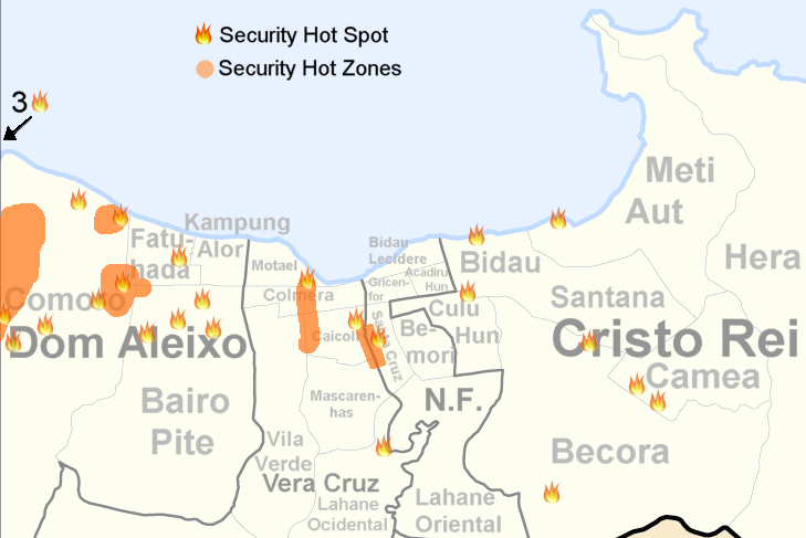
Security Hot Zones and Spots of Dili, 24. Oktober 2006 |
| Date | (UTC) |
| Source | |
| Author |
|
| This is a retouched picture, which means that it has been digitally altered from its original version. Modifications: Informations and colours. The original can be viewed here: Administrative map of the Dilli district of East Timor.png:
|
Informations from Internal Displacement Monitoring Center
I, the copyright holder of this work, hereby publish it under the following license:
This file is licensed under the Creative Commons Attribution-Share Alike 2.5 Generic license.
- You are free:
- to share – to copy, distribute and transmit the work
- to remix – to adapt the work
- Under the following conditions:
- attribution – You must give appropriate credit, provide a link to the license, and indicate if changes were made. You may do so in any reasonable manner, but not in any way that suggests the licensor endorses you or your use.
- share alike – If you remix, transform, or build upon the material, you must distribute your contributions under the same or compatible license as the original.
Original upload log
This image is a derivative work of the following images:
- File:Administrative_map_of_the_Dilli_district_of_East_Timor.png licensed with Cc-by-sa-2.5
- 2009-09-22T05:17:49Z Chumwa 1441x1928 (185415 Bytes) Ausschnittvergrößreung von Dilli hinzugefügt
- 2009-09-19T06:07:46Z Chumwa 1441x1928 (135878 Bytes) {{Information |Description= {{ de }} Verwaltungskarte des Distrikts Dilli in Osttimor {{ en }} Administrative map of the Dilli district of East Timor |Source=Self made, using informations from the[http://websig.civil.ist.utl.
Uploaded with derivativeFX
File history
Click on a date/time to view the file as it appeared at that time.
| Date/Time | Thumbnail | Dimensions | User | Comment | |
|---|---|---|---|---|---|
| current | 11:48, 18 November 2010 | | 729 × 487 (106 KB) | J. Patrick Fischer | {{Information |Description={{ en }} Security Hot Zones and Spots of Dili, 24. Oktober 2006 |Source=*File:Administrative_map_of_the_Dilli_district_of_East_Timor.png |Date=2010-11-18 11:43 (UTC) |Author=*[[:File:Administrative_map_of_the_Dilli_distric |
File usage
The following pages on the English Wikipedia use this file (pages on other projects are not listed):
Global file usage
The following other wikis use this file:
- Usage on de.wikipedia.org
- Usage on fr.wikipedia.org
- Usage on pt.wikipedia.org