

Size of this PNG preview of this SVG file: 800 × 563 pixels. Other resolutions: 320 × 225 pixels | 640 × 451 pixels | 1,024 × 721 pixels | 1,280 × 901 pixels | 2,560 × 1,802 pixels | 1,500 × 1,056 pixels.
Original file (SVG file, nominally 1,500 × 1,056 pixels, file size: 3.13 MB)
| This is a file from the Wikimedia Commons. Information from its description page there is shown below. Commons is a freely licensed media file repository. You can help. |
| This is a featured picture, which means that members of the community have identified it as one of the finest images on the English Wikipedia, adding significantly to its accompanying article. If you have a different image of similar quality, be sure to upload it using the proper free license tag, add it to a relevant article, and nominate it. |
| This image was selected as picture of the day on the English Wikipedia for July 27, 2008. |
|

Summary
This W3C-unspecified vector image was created with Inkscape .
| Title |
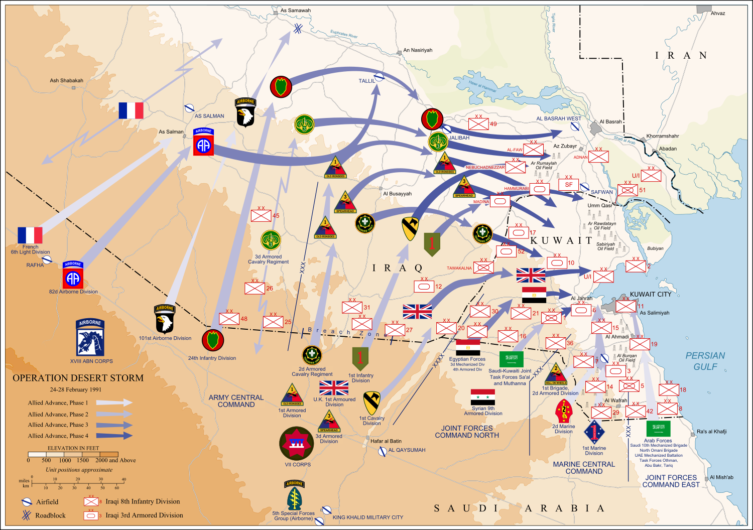
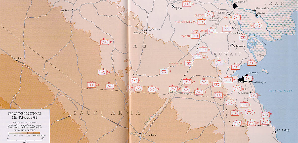
Operation Desert Storm |
||||
| Description |
العربية: عملية عاصفة الصحراء، ضمن حرب الخليج الثانية، 24-28 شباط/ فبراير 1991.
English: Map of ground operations of Operation Desert Storm starting invasion February 24-28th 1991. Shows allied and Iraqi forces. Special arrows indicate the American 101st Airborne division moved by air and where the French 6st light division and American 3rd Armored Cavalry Regiment provided security.
Français : Carte montrant les opérations terrestres menées lors de l'opération Tempête du désert entre le 24 et le 28 février 1991 : les positions tenues par les armées irakienne et alliées, et les mouvements de cette dernière. Des flèches particulières indiquent les manœuvres héliportées pratiquées par la 101e division aéroportée, ainsi que les zones sécurisées par la 6e brigade légère blindée française et par le 3e régiment blindé de cavalerie américain. |
||||
| Date | (UTC) | ||||
| Source | self-vectored from Image:Operation Desert Storm.jpg from this site and this site. | ||||
| Creator |
US Army |
||||
| Geotemporal data | |||||
| Date depicted | |||||
| Map location | Iraq/Kuwait border | ||||
| OpenStreetMap zoom level | 9 | ||||
| Bounding box |
|
||||
| Georeferencing | |||||
| Bibliographic data | |||||
| Language | eng | ||||
| Archival data | |||||
| Medium | Inkscape SVG | ||||
| Other versions |
 |
||||

Licensing
This file is a work of a U.S. Army soldier or employee, taken or made as part of that person's official duties. As a work of the U.S. federal government, it is in the public domain in the United States.
|
 |
I, the copyright holder of this work, hereby publish it under the following licenses:

|
Permission is granted to copy, distribute and/or modify this document under the terms of the GNU Free Documentation License, Version 1.2 or any later version published by the Free Software Foundation; with no Invariant Sections, no Front-Cover Texts, and no Back-Cover Texts. A copy of the license is included in the section entitled GNU Free Documentation License. |
This file is licensed under the Creative Commons Attribution-Share Alike 4.0 International, 3.0 Unported, 2.5 Generic, 2.0 Generic and 1.0 Generic license.
- You are free:
- to share – to copy, distribute and transmit the work
- to remix – to adapt the work
- Under the following conditions:
- attribution – You must give appropriate credit, provide a link to the license, and indicate if changes were made. You may do so in any reasonable manner, but not in any way that suggests the licensor endorses you or your use.
- share alike – If you remix, transform, or build upon the material, you must distribute your contributions under the same or compatible license as the original.
You may select the license of your choice.
File history
Click on a date/time to view the file as it appeared at that time.
| Date/Time | Thumbnail | Dimensions | User | Comment | |
|---|---|---|---|---|---|
| current | 13:14, 9 June 2012 | | 1,500 × 1,056 (3.13 MB) | Coolland | uploaded with x-external-editor |
| 04:31, 6 February 2008 |  | 1,500 × 1,056 (3.13 MB) | Jeff Dahl | flags/label edits | |
| 21:00, 4 February 2008 |  | 1,500 × 1,056 (2.89 MB) | Jeff Dahl | == Summary == {{Inkscape}} {{Information |Description=Map of ground operations of Operation Desert Storm from February 24-28th 1991. Shows allied and Iraqi forces. |Source=self-made, vectored from Image:Operation Desert Storm.jpg from [http://www.his |
File usage
The following pages on the English Wikipedia use this file (pages on other projects are not listed):
- 101st Airborne Division
- 1st (United Kingdom) Division
- 1st Brigade, 24th Infantry Division (United States)
- 1st Cavalry Division (United States)
- 1st Foreign Cavalry Regiment
- 24th Infantry Division (United States)
- 2nd Brigade, 24th Infantry Division (United States)
- 3rd Armored Division (United States)
- 6th Foreign Engineer Regiment
- 82nd Airborne Division
- 82nd Sustainment Brigade
- Air assault
- Armed Forces of Saudi Arabia
- Battle of Khafji
- Division Daguet
- French Foreign Legion
- Gulf War
- Gulf War syndrome
- History of the 101st Airborne Division
- Iraqi invasion of Kuwait
- John J. Yeosock
- Kuwait Armed Forces
- List of conflicts in Asia
- Norman Schwarzkopf Jr.
- Opération Daguet
- Order of battle of the Gulf War ground campaign
- Royal Green Jackets (Rifles) Museum
- Tanks in the British Army
- Tanks of the Soviet Union
- VII Corps (United States)
Global file usage
The following other wikis use this file:
- Usage on an.wikipedia.org
- Usage on ar.wikipedia.org
- Usage on bg.wikipedia.org
- Usage on br.wikipedia.org
- Usage on ca.wikipedia.org
- Usage on cs.wikipedia.org
- Usage on de.wikipedia.org
- Usage on el.wikipedia.org
- Usage on es.wikipedia.org
- Usage on fa.wikipedia.org
- Usage on fr.wikipedia.org
- Usage on fy.wikipedia.org
- Usage on gu.wikipedia.org
- Usage on he.wikipedia.org
- Usage on hi.wikipedia.org
- Usage on hy.wikipedia.org
- Usage on id.wikipedia.org
- Usage on it.wikipedia.org
- Usage on ja.wikipedia.org
- Usage on kn.wikipedia.org
- Usage on ko.wikipedia.org
- Usage on mr.wikipedia.org
View more global usage of this file.