
Size of this preview: 580 × 599 pixels. Other resolutions: 232 × 240 pixels | 600 × 620 pixels.
Original file (600 × 620 pixels, file size: 137 KB, MIME type: image/png)
| This is a file from the Wikimedia Commons. Information from its description page there is shown below. Commons is a freely licensed media file repository. You can help. |

|
This map image could be re-created using vector graphics as an SVG file. This has several advantages; see Commons:Media for cleanup for more information. If an SVG form of this image is available, please upload it and afterwards replace this template with
{{vector version available|new image name}}.
It is recommended to name the SVG file “Dardanelles defences 1915.svg”—then the template Vector version available (or Vva) does not need the new image name parameter. |
Summary
| Description |
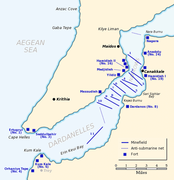
Map of the Dardanelles defences in February and March, 1915. The original lines of naval mines are numbered 1 to 10. The 11th line, laid in Erin Keui Bay by the minelayer Nusrat on 8 March, is numbered 11. The anti-submarine nets are shown as dotted lines. Major forts are indicated with blue boxes and the Turkish name and equivalent British number for the fort is given, if known. |
| Date | |
| Source |
Own work based on:
|
| Author | Gsl |
| Permission (Reusing this file) |
Released to public domain |
| This work has been released into the public domain by its author, Gsl. This applies worldwide. In some countries this may not be legally possible; if so: |
File history
Click on a date/time to view the file as it appeared at that time.
| Date/Time | Thumbnail | Dimensions | User | Comment | |
|---|---|---|---|---|---|
| current | 18:02, 21 June 2012 | | 600 × 620 (137 KB) | Hohum | Clearer colours |
| 16:51, 22 June 2005 |  | 600 × 620 (74 KB) | <bdi>Redtony</bdi> | Map of the Dardanelles defences in February and March, 1915. The original lines of naval mines are numbered 1 to 10. The 11th line, laid in Erin Keui Bay by the minelayer ''Nusrat'' on 8 March, is numbered 11. The anti-submarine nets are shown as d |
File usage
The following pages on the English Wikipedia use this file (pages on other projects are not listed):
- Charlemagne-class battleship
- Dardanelles Fortified Area Command
- Eric Gascoigne Robinson
- French battleship Charlemagne
- French battleship Gaulois
- French battleship Suffren
- Gulf of Erenköy
- HMS Agamemnon (1906)
- HMS Albion (1898)
- HMS Cornwallis (1901)
- HMS Goliath (1898)
- HMS Irresistible (1898)
- HMS Ocean (1898)
- HMS Vengeance (1899)
- Lord Nelson-class battleship
- Naval operations in the Dardanelles campaign
- Ottoman minelayer Intibah
- SMS Kurfürst Friedrich Wilhelm
- SMS Weissenburg
Global file usage
The following other wikis use this file:
- Usage on ast.wikipedia.org
- Usage on be-tarask.wikipedia.org
- Usage on be.wikipedia.org
- Usage on bg.wikipedia.org
- Usage on ca.wikipedia.org
- Usage on de.wikipedia.org
- Usage on es.wikipedia.org
- Usage on fr.wikipedia.org
- Usage on he.wikipedia.org
- Usage on it.wikipedia.org
- Usage on ja.wikipedia.org
- Usage on ka.wikipedia.org
- Usage on pl.wikipedia.org
- Usage on pt.wikipedia.org
- Usage on ru.wikipedia.org
- Usage on tr.wikipedia.org
- Usage on uk.wikipedia.org
- Usage on www.wikidata.org
- Usage on zh.wikipedia.org