

Size of this PNG preview of this SVG file: 799 × 334 pixels. Other resolutions: 320 × 134 pixels | 640 × 268 pixels | 1,024 × 428 pixels | 1,280 × 535 pixels | 2,560 × 1,070 pixels | 1,019 × 426 pixels.
Original file (SVG file, nominally 1,019 × 426 pixels, file size: 242 KB)
| This is a file from the Wikimedia Commons. Information from its description page there is shown below. Commons is a freely licensed media file repository. You can help. |
Summary
| Title |
Routes of the British Expedition and the Patriot Messengers |
||||||||||||||||||||
| Description |
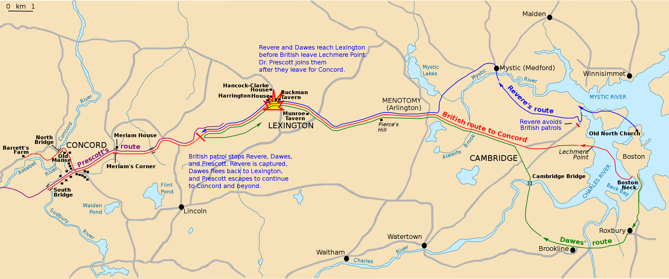
Paul Revere's Midnight Ride English: This is a map depiction the outbound routes taken by Patriot riders and British troops in the Battles of Lexington and Concord on April 19, 1775. |
||||||||||||||||||||
| Map legend |
British route to Concord Revere's route Dawes' route Prescott's route |
||||||||||||||||||||
| Date | Unknown date; source PDF was created in 2000 | ||||||||||||||||||||
| Source | Own work based on: Concord Expedition and Patriot Messengers-fr.svg by Augusta 89 | ||||||||||||||||||||
| Creator |
Unknown author for National Park Service |
||||||||||||||||||||
| Geotemporal data | |||||||||||||||||||||
| Date depicted | |||||||||||||||||||||
| Map location | Boston, Middlesex County, Massachusetts | ||||||||||||||||||||
| Map type | thematic map | ||||||||||||||||||||
| Heading |
 |
||||||||||||||||||||
| Bibliographic data | |||||||||||||||||||||
| Publisher |
National Park Service |
||||||||||||||||||||
| Archival data | |||||||||||||||||||||
| Collection |
|
||||||||||||||||||||
| Inscriptions |
Text center: Revere and Dawes reach Lexington before British leave Lechmere Point. Dr. Prescott joins them after they leave for Concord.
Text center:
British patrol stops Revere, Dawes, and Prescott. Revere is captured, Dawes flees back to Lexington, and Prescott escapes to continue to Concord and beyond.
|
||||||||||||||||||||
| Other versions |
|
||||||||||||||||||||


Licensing
Map
translation (French to English)
|

|
This media file is uncategorized.
Please help improve this media file by adding it to one or more categories, so it may be associated with related media files (how?), and so that it can be more easily found.
Please notify the uploader with {{subst:Please link images|File:Concord Expedition and Patriot Messengers-en.svg}} ~~~~ |
File history
Click on a date/time to view the file as it appeared at that time.
| Date/Time | Thumbnail | Dimensions | User | Comment | |
|---|---|---|---|---|---|
| current | 07:35, 15 March 2021 | | 1,019 × 426 (242 KB) | ΟΥΤΙΣ | == {{int:filedesc}} == {{Map |title = {{title|Routes of the British Expedition and the Patriot Messengers|lang=en}} |description = {{label|Q97327423}} {{en|This is a map depiction the outbound routes taken by Patriot riders and British troops in the Battles of Lexington and Concord on April 19, 1775.}} |legend = {{legend|#AD302E|British ro... |
File usage
The following pages on the English Wikipedia use this file (pages on other projects are not listed):