

Size of this PNG preview of this SVG file: 800 × 597 pixels. Other resolutions: 320 × 239 pixels | 640 × 477 pixels | 1,024 × 764 pixels | 1,280 × 955 pixels | 2,560 × 1,910 pixels | 1,720 × 1,283 pixels.
Original file (SVG file, nominally 1,720 × 1,283 pixels, file size: 2.8 MB)
| This is a file from the Wikimedia Commons. Information from its description page there is shown below. Commons is a freely licensed media file repository. You can help. |
Summary
| Description |
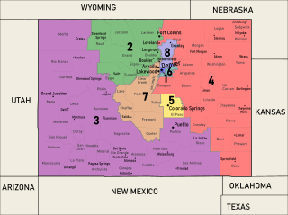
Map of the congressional districts of Colorado, approved on November 1, 2021, complemented with neighbouring states, counties, and major cities. These congressional districts will be put into effect from 2023 to 2033, following the 2022 US House elections. Adapted from the style of File:Colorado Congressional Districts, 113th Congress.tif, the National Atlas (https://web.archive.org/web/20140209101748/http://nationalatlas.gov/printable/images/pdf/congdist/pagecgd113_co.pdf). Among the shapefiles used: https://coleg.maps.arcgis.com/apps/View/index.html?appid=5b67525550b347219dbfa72482462f3f (congressional districts and counties), https://www.arcgis.com/home/item.html?id=e26f2752e86d4a8dad52ea75501480f0 (states). Data from (but not limited to) Esri and the Colorado Independent Redistricting Commissions. Made with ArcGIS and Inkscape. Some inaccuracies may exist due to human error. |
| Date | |
| Source | Own work |
| Author | Twotwofourtysix |
Licensing
I, the copyright holder of this work, hereby publish it under the following license:
| This file is made available under the Creative Commons CC0 1.0 Universal Public Domain Dedication. | |
| The person who associated a work with this deed has dedicated the work to the public domain by waiving all of their rights to the work worldwide under copyright law, including all related and neighboring rights, to the extent allowed by law. You can copy, modify, distribute and perform the work, even for commercial purposes, all without asking permission.
|
File history
Click on a date/time to view the file as it appeared at that time.
| Date/Time | Thumbnail | Dimensions | User | Comment | |
|---|---|---|---|---|---|
| current | 06:23, 4 January 2022 | | 1,720 × 1,283 (2.8 MB) | Twotwofourtysix | Uploaded own work with UploadWizard |
File usage
The following pages on the English Wikipedia use this file (pages on other projects are not listed):
Global file usage
The following other wikis use this file:
- Usage on it.wikipedia.org
- Usage on ja.wikipedia.org
- Usage on simple.wikipedia.org