

Size of this PNG preview of this SVG file: 523 × 599 pixels. Other resolutions: 209 × 240 pixels | 419 × 480 pixels | 670 × 768 pixels | 894 × 1,024 pixels | 1,787 × 2,048 pixels | 2,448 × 2,805 pixels.
Original file (SVG file, nominally 2,448 × 2,805 pixels, file size: 260 KB)
| This is a file from the Wikimedia Commons. Information from its description page there is shown below. Commons is a freely licensed media file repository. You can help. |
Summary
| Description |
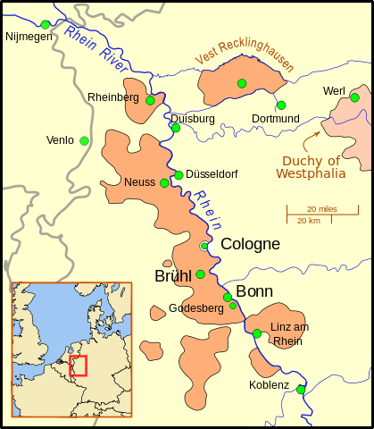
A map of the Electorate of Cologne showing major cities of the Electorate (Cologne, Bruhl, Bonn) as well as towns involved in the War and other important cities in the area.
The gray lines show modern day national borders. Except for the Emscher river, the rivers are shown in their modern routes/channels/paths. This map uses a Mercator projection. |
| Date | |
| Source |
Own work using:
|
| Author | MapMaster |
| Other versions | A locator map (i.e. without text) can be found at File:Archbishopric of Cologne Locator Map 1.svg |
Licensing
I, the copyright holder of this work, hereby publish it under the following license:
This file is licensed under the Creative Commons Attribution 3.0 Unported license.
- You are free:
- to share – to copy, distribute and transmit the work
- to remix – to adapt the work
- Under the following conditions:
- attribution – You must give appropriate credit, provide a link to the license, and indicate if changes were made. You may do so in any reasonable manner, but not in any way that suggests the licensor endorses you or your use.
File history
Click on a date/time to view the file as it appeared at that time.
| Date/Time | Thumbnail | Dimensions | User | Comment | |
|---|---|---|---|---|---|
| current | 03:06, 12 October 2009 | | 2,448 × 2,805 (260 KB) | MapMaster | Minor improvements |
| 12:45, 6 October 2009 |  | 2,448 × 2,805 (260 KB) | MapMaster | Added Nijmegen, Westphalia, and better background | |
| 17:40, 5 October 2009 |  | 2,448 × 2,805 (247 KB) | MapMaster | {{Information |Description={{en|1=A map of the Electorate of Cologne showing major cities of the Electorate (Cologne, Bruhl, Bonn) as well as towns involved in the War and other important cities in the area. }} |Source={{own}} |Author=[[User:MapMaster|Ma |
File usage
The following pages on the English Wikipedia use this file (pages on other projects are not listed):
Global file usage
The following other wikis use this file:
- Usage on eo.wikipedia.org
- Usage on es.wikipedia.org
- Usage on it.wikipedia.org
- Usage on no.wikipedia.org
- Usage on pt.wikipedia.org
- Usage on ru.wikipedia.org
- Usage on sl.wikipedia.org
- Usage on www.wikidata.org
- Usage on zh.wikipedia.org