To install click the Add extension button. That's it.

The source code for the WIKI 2 extension is being checked by specialists of the Mozilla Foundation, Google, and Apple. You could also do it yourself at any point in time.

4,5
Kelly Slayton
Congratulations on this excellent venture… what a great idea!
Alexander Grigorievskiy
I use WIKI 2 every day and almost forgot how the original Wikipedia looks like.
Live Statistics
English Articles
Improved in 24 Hours
Added in 24 Hours
What we do. Every page goes through several hundred of perfecting techniques; in live mode. Quite the same Wikipedia. Just better.
.
Leo
Newton
Brights
Milds

File:Christiana-Riot-Map-1851.png

From Wikipedia, the free encyclopedia

Original file(1,688 × 1,632 pixels, file size: 4.25 MB, MIME type: image/png)

Summary

Description
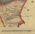
A portion of an 1851 map showing various places of importance for the Christiana Riot. Notably Penningtonville station in Chester county, the community of Christiana in Sadsbury Township (Lancaster county). The Parker house where the attack took place is located in the Pownall Tract.
Date
Source A map derived from the Map of Lancaster County, Pennsylvania, published 1851 and held by the Library of Congress https://www.loc.gov/item/2012592191/ The derivation is a small portion of the map depicting Christiana, PA and with the map scale moved to be on this portion.
Author Original author is not listed. I create the derivation

Licensing

Public domain
This work is in the public domain in the United States because it was published (or registered with the U.S. Copyright Office) before January 1, 1929.

Public domain works must be out of copyright in both the United States and in the source country of the work in order to be hosted on the Commons. If the work is not a U.S. work, the file must have an additional copyright tag indicating the copyright status in the source country.
Note: This tag should not be used for sound recordings.PD-1923Public domain in the United States//commons.wikimedia.org/wiki/File:Christiana-Riot-Map-1851.png

Captions

Map of the area of Christiana, Pennsylvania at the time of the 1851 Christiana Riot

Items portrayed in this file

depicts

image/png

db3ed016bda1cdf687527a2d6d3bb6e95eb22211

4,451,918 byte

1,632 pixel

1,688 pixel

File history

Click on a date/time to view the file as it appeared at that time.

Date/TimeThumbnailDimensionsUserComment
current07:39, 2 February 2019Thumbnail for version as of 07:39, 2 February 20191,688 × 1,632 (4.25 MB)ErpUser created page with UploadWizard
The following pages on the English Wikipedia use this file (pages on other projects are not listed):

Global file usage

The following other wikis use this file:

Metadata

Basis of this page is in Wikipedia. Text is available under the CC BY-SA 3.0 Unported License. Non-text media are available under their specified licenses. Wikipedia® is a registered trademark of the Wikimedia Foundation, Inc. WIKI 2 is an independent company and has no affiliation with Wikimedia Foundation.