
Size of this preview: 800 × 555 pixels. Other resolutions: 320 × 222 pixels | 640 × 444 pixels | 1,024 × 711 pixels | 1,280 × 888 pixels | 2,560 × 1,777 pixels | 3,500 × 2,429 pixels.
Original file (3,500 × 2,429 pixels, file size: 2.87 MB, MIME type: image/jpeg)
| This is a file from the Wikimedia Commons. Information from its description page there is shown below. Commons is a freely licensed media file repository. You can help. |
Summary
|
This is an image of a place or building that is listed on the National Register of Historic Places in the United States of America. Its reference number is 66000134. |
| Description |
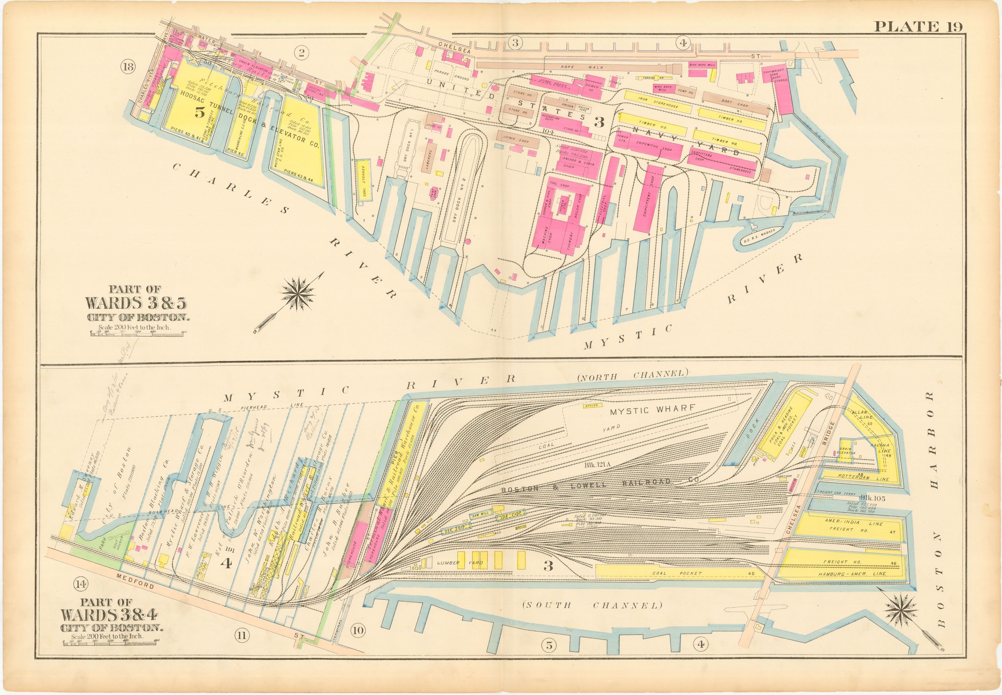
This is a map of the Charlestown Navy Yard and Mystic Wharf in 1912. The map is from an atlas of Charlestown, Massachusetts published by GW Bromley. The map's original size is about 22"x32". |
| Date | |
| Source | WardMaps |
| Author | G.W. Bromley |
| Object location | | View this and other nearby images on: OpenStreetMap |
|---|
Licensing
This work is in the public domain in the United States because it was published (or registered with the U.S. Copyright Office) before January 1, 1929.
Public domain works must be out of copyright in both the United States and in the source country of the work in order to be hosted on the Commons. If the work is not a U.S. work, the file must have an additional copyright tag indicating the copyright status in the source country.
Note: This tag should not be used for sound recordings. |
Original upload log
The original description page was here. All following user names refer to en.wikipedia.
- 2006-05-31 19:54 Bluemanboston 500×347×8 (35244 bytes) This is a map of the Charlestown Navy Yard and Mystic Wharf in 1912. The map is from an atlas of Charlestown, Massachusetts published by GW Bromley. The map's original size is about 22"x32". Source: downloaded from http://wardmaps.com/ward_maps/charlesto
File history
Click on a date/time to view the file as it appeared at that time.
| Date/Time | Thumbnail | Dimensions | User | Comment | |
|---|---|---|---|---|---|
| current | 22:35, 24 December 2013 | | 3,500 × 2,429 (2.87 MB) | Pi1415926535 | Larger version |
| 12:11, 30 December 2007 |  | 500 × 347 (34 KB) | PMG | {{Information |Description={{en|This is a map of the Charlestown Navy Yard and Mystic Wharf in 1912. The map is from an atlas of Charlestown, Massachusetts published by GW Bromley. The map's original size is about 22"x32". Source: downloaded from http:// |
File usage
The following pages on the English Wikipedia use this file (pages on other projects are not listed):
Global file usage
The following other wikis use this file:
- Usage on de.wikipedia.org
- Usage on it.wikipedia.org
- Usage on ja.wikipedia.org
- Usage on ru.wikipedia.org
- Usage on simple.wikipedia.org