
No higher resolution available.
Central_and_Eastern_Europe_around_950_AD.png (628 × 525 pixels, file size: 272 KB, MIME type: image/png)
| This is a file from the Wikimedia Commons. Information from its description page there is shown below. Commons is a freely licensed media file repository. You can help. |

Summary
| Description |
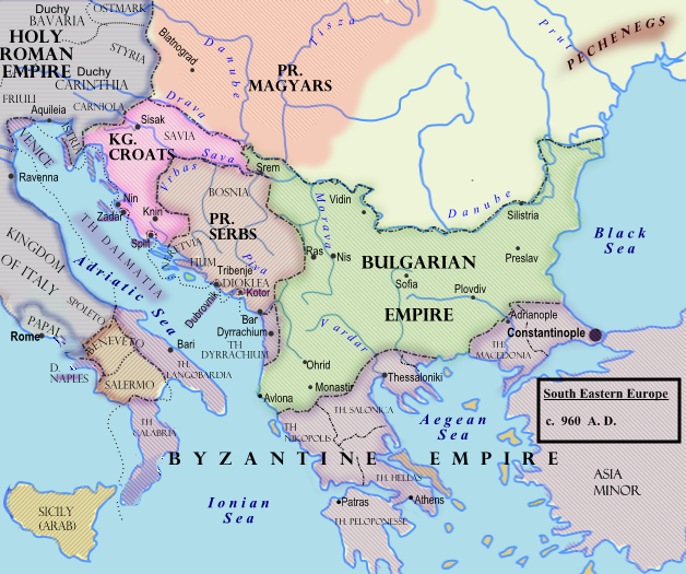
Southeastern Europe around 950 AD
|
| Date | 7 February 2009 (original upload date) |
| Source |
Transferred from en.wikipedia to Commons.
|
| Author | Hxseek at English Wikipedia |
![[3]](http://www.lib.utexas.edu/maps/historical/shepherd/europe_byzantine_empires.jpg)
Licensing
| This work has been released into the public domain by its author, Hxseek at English Wikipedia. This applies worldwide. In some countries this may not be legally possible; if so: Hxseek grants anyone the right to use this work for any purpose, without any conditions, unless such conditions are required by law. |
Original upload log
The original description page was here. All following user names refer to en.wikipedia.
- 2009-02-07 03:50 Hxseek 628×525× (278873 bytes)
File history
Click on a date/time to view the file as it appeared at that time.
| Date/Time | Thumbnail | Dimensions | User | Comment | |
|---|---|---|---|---|---|
| current | 10:07, 26 March 2009 | | 628 × 525 (272 KB) | Captain-tucker | {{Information |Description={{en|== Licensing: ==}} |Source=Transferred from [http://en.wikipedia.org en.wikipedia] |Date=2009-02-07 (original upload date) |Author=Original uploader was Hxseek at [http://en.wikipedia.org en.wikipedia] | |
File usage
The following pages on the English Wikipedia use this file (pages on other projects are not listed):
Global file usage
The following other wikis use this file:
- Usage on azb.wikipedia.org
- Usage on be-tarask.wikipedia.org
- Usage on be.wikipedia.org
- Usage on bg.wikipedia.org
- Usage on el.wikipedia.org
- Usage on es.wikipedia.org
- Usage on et.wikipedia.org
- Usage on fi.wikipedia.org
- Usage on fr.wikipedia.org
- Usage on gl.wikipedia.org
- Usage on hu.wikipedia.org
- Usage on it.wikipedia.org
- Usage on lt.wikipedia.org
- Usage on lv.wikipedia.org
- Usage on mk.wikipedia.org
- Usage on pl.wikipedia.org
- Usage on pt.wikipedia.org
- Usage on ro.wikipedia.org
- Usage on ru.wikipedia.org
- Usage on sh.wikipedia.org
- Usage on sl.wikipedia.org
- Usage on sr.wikipedia.org
- Usage on th.wikipedia.org
- Usage on uk.wikipedia.org