To install click the Add extension button. That's it.

The source code for the WIKI 2 extension is being checked by specialists of the Mozilla Foundation, Google, and Apple. You could also do it yourself at any point in time.

4,5
Kelly Slayton
Congratulations on this excellent venture… what a great idea!
Alexander Grigorievskiy
I use WIKI 2 every day and almost forgot how the original Wikipedia looks like.
Live Statistics
English Articles
Improved in 24 Hours
Added in 24 Hours
What we do. Every page goes through several hundred of perfecting techniques; in live mode. Quite the same Wikipedia. Just better.
.
Leo
Newton
Brights
Milds

File:Carte TGV.svg

From Wikipedia, the free encyclopedia

Original file(SVG file, nominally 1,000 × 1,056 pixels, file size: 992 KB)

Summary

This file may be updated to reflect new information.
If you wish to use a specific version of the file without new updates being mirrored, please upload the required version as a separate file.
Description
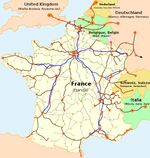
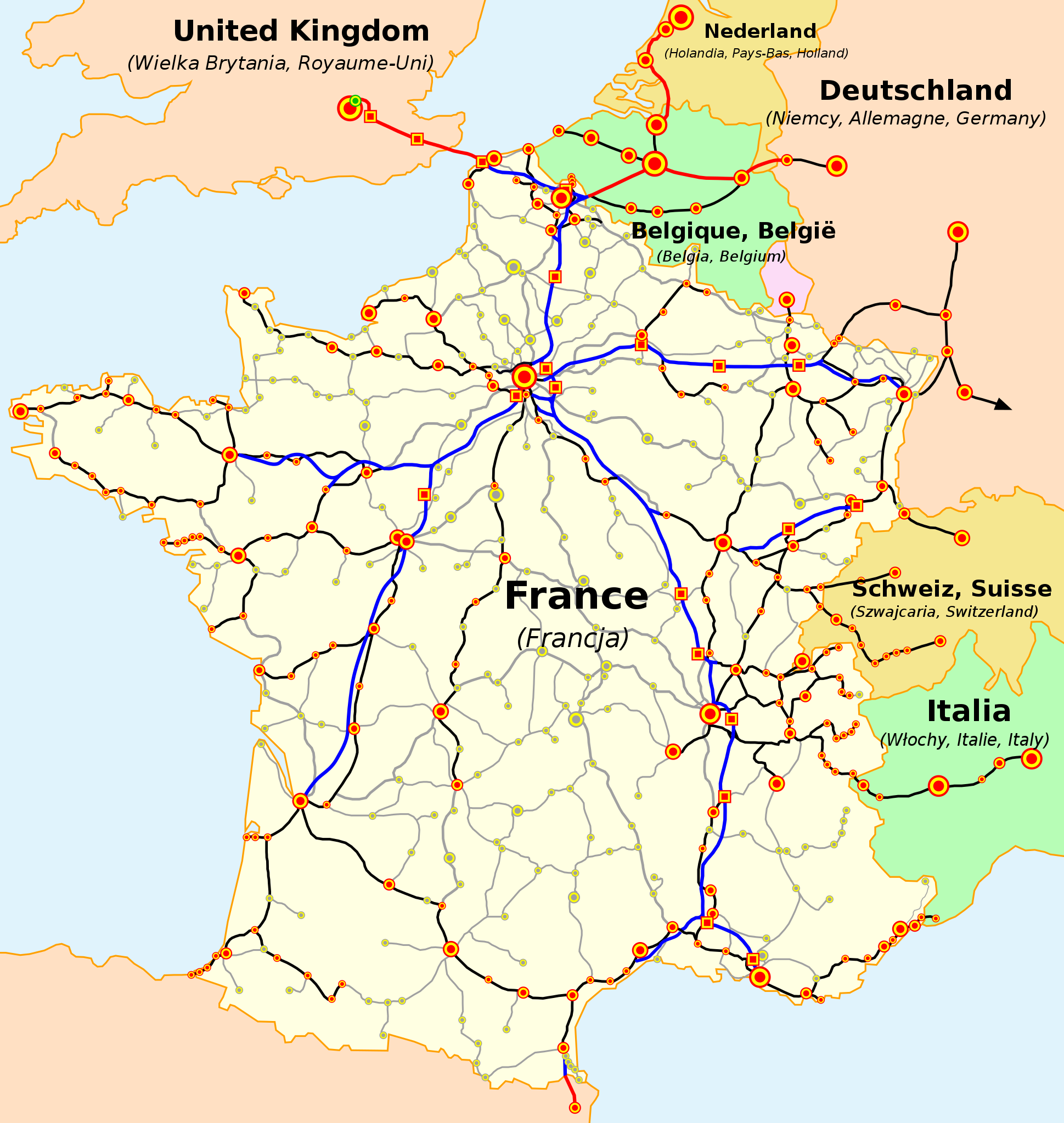
The map of French railways (SNCF) passengers service, including international TGV high-speed trains

(cs) Vysvětlivky

  • Železniční tratě:
    • modrá — vysokorychlostní tratě (LGV) ve Francii
    • červená — vysokorychlostní tratě mimo Francii
    • černá — běžné tratě s provozem TGV
    • čárkovaná červená/modrá — vysokorychlostní tratě ve stavbě
    • čárkovaná černá — běžné tratě s plánovaným provozem TGV v blízké budoucnosti
    • šedá — ostatní tratě s dopravou cestujících
  • Železniční stanice a města:
    • červená:
      • kruhy — stanice obsluhovaná TGV
      • čtverce — stanice obsluhovaná výhradně TGV (na LGV)
    • zelená:
      • kruhy — stanice s plánovanou obsluhou TGV v blízké budoucnosti
      • čtverce — stanice na LGV ve stavbě
    • šedá — stanice s dopravou cestujících běžnými vlaky

Velikost značek označuje přibližně velikost měst

(de) Legende

  • Eisenbahnlinien:
    • blau - Hochgeschwindigkeitsstrecken in Frankreich,
    • rot - Hochgeschwindigkeitsstrecken außerhalb Frankreichs,
    • schwarz - Klassische Bahnlinien mit TGV-Nutzung,
    • rot und blau gepunktet - Hochgeschwindigkeitsstrecken in Bau,
    • schwarz gepunktet - Klassische Bahnlinien mit TGV-Nutzung in Planung,
    • grau - andere klassische Bahnlinien im Passagierverkehr
  • Bahnhöfe und Städte:
    • rot:
      • Punkte - mit TGV Anbindung,
      • Quadrate - ausschließlich TGV Anbindung
    • grün:
      • Punkte - mit zukünftiger TGV Anbindung,
      • Quadrate - mit zukünftiger, ausschließlicher TGV Anbindung,
    • Graue Punkte - andere Personenbahnhöfe,
Die Größe der Punkte spiegelt die Größe der Städte wieder.

(es) Leyenda

  • Lineas Ferroviarias:
    • Azul- Lineas de alta velocidad (LGV) en Francia.
    • Rojo- Lineas de alta velocidad exteriores a Francia.
    • Negro- Lineas ferroviarias "clasicas" con servicio TGV.
    • Azul y Rojo punteados- Lineas de alta velocidad en construcción.
    • Negro punteado- Lineas "clasicas" con servicio TGV planeadas para un futuro cercano.
    • Gris- Otras lineas ferroviarias "clasicas" con servicio de pasajeros.
  • Estaciones Ferroviarias o Ciudades:
    • Rojo:
      • Puntos- Con servicio TGV
      • Cuadrados- Con servicio TGV solamente (Estaciones en LGV)
    • Verde:
        • Puntos- Con servicio TGV en un futuro cercano.
        • Cuadrados- Con servicio TGV solamente (Estaciones en LGV). En construcción.
    • Puntos Grises- Con otros servicios de pasajeros; los tamaños del punto indican los tamaños de la ciudad (arbitrarios).

(en) Legend

  • Railway lines:
    • blue - high-speed (LGV) lines in France,
    • red - high-speed lines outside France,
    • black - 'classic' railway lines with TGV service,
    • dashed red and blue - high-speed lines in construction,
    • dashed black - 'classic' lines with TGV service planned in near future,
    • grey - other 'classic' railway lines with passenger service.
  • Railway stations or cities:
    • red:
      • dots - with TGV service,
      • squares - with TGV service only (stations on LGV)
    • green:
      • dots - with TGV service in near future,
      • squares with TGV service only (stations on LGV) in construction,
    • grey dots - with other passenger service,
dot sizes indicate town sizes (arbitrary).

(fr) Légende

  • Lignes ferroviaires:
    • bleus - lignes à grande vitesse (LGV) en France,
    • rouges - lignes à grande vitesse au dehors de la France,
    • noires - lignes 'classiques' avec le service TGV,
    • rouges et bleues entrecoupées - lignes à grande vitesse en construction,
    • noires entrecoupées - lignes 'classiques' dont le service TGV est prévu,
    • grises - autres lignes 'classiques' du réseau voyageurs.
  • Gares ferroviaires ou villes:
    • rouges:
      • points - avec le service TGV,
      • carreaux - avec le service TGV uniquement (gares sur les lignes nouvelles)
    • verts:
      • points - dont le service TGV est prévu,
      • carreaux - pour les TGV uniquement (gares sur les lignes nouvelles, en construction),
    • points gris - les autres stations ou villes du réseau voyageurs.
les tailles des points indiquent les grandeurs des villes (subjective)

(nl) Legenda

  • Spoorwegen:
    • blauw - hogesnelheidslijnen (LGV) in Frankrijk
    • rood - hogesnelheidslijnen buiten Frankrijk
    • zwart - oude lijnen met hogesnelheidstreinen
    • rood-blauwe stippellijn - hogesnelheidslijn in opbouw
    • zwarte stippellijn - oude lijnen waarop hogesnelheidstreinen gepland worden
    • grijs: andere oude lijnen voor personenvervoer
  • Stations en steden:
    • rood:
      • bollen - bediend door de HST
      • vierkanten - enkel bediend door de HST (stations langs nieuwe lijnen)
    • groen:
      • bollen - plaats waar bediening door de HST wordt gepland
      • vierkanten - enkel bediening door de HST wordt voorzien
    • grijze bollen - andere stations en steden voor personenvervoer
de grootte van de bollen geven de grootte van de steden weer (subjectief)

(pl) Legenda

  • Linie kolejowe:
    • niebieskie - linie wysokich prędkości (LGV) we Francji,
    • czerwone - linie wysokich prędkości poza Francją,
    • czarne - linie "klasyczne", po których kursują pociągi TGV,
    • czerwone i niebieskie przerywane - linie wysokich prędkości w budowie,
    • czarne przerywane - linie 'klasyczne' po który pociągi TGV będą kursować w niedalekiej przyszłości,
    • szare - pozostałe linie "klasyczne", po których kursują pociągi pasażerskie.
  • Dworce kolejowe lub miasta:
    • czerwone:
      • punkty - na których zatrzymują się pociągi TGV,
      • kwadraty - na których zatrzymują się wyłącznie pociągi TGV (dworce na liniach wysokich prędkości),
    • zielone:
      • punkty - do których pociągi TGV dotrą w niedalekiej przyszłości,
      • kwadraty - dworce w budowie, przeznaczone wyłącznie dla pociągów TGV,
    • szare punkty - pozostałe dworce kolejowe na liniach "klasycznych".
wielkość punktów wskazuje wielkość stacji lub miasta (subiektywnie).

(sk) Vysvetlivky

  • Železničné trate:
    • modrá - vysokorýchlostné trate (LGV) vo Francúzsku,
    • červená - vysokorýchlostné trate mimo Francúzska,
    • čierna - štandardné trate s prevádzkou TGV,
    • prerušovaná červeno-modrá - vysokorýchlostné trate vo výstavbe,
    • prerušovaná čierna - štandardné trate s prevádzkou TGV plánovanou v blízkej budúcnosti,
    • šedá - ďalšie štandardné trate s prepravou cestujúcich.


  • Železničné stanice alebo mestá:
    • červená:
      • body - s prevádzkou TGV ,
      • štvorce - len s prevádzkou TGV (stanice na LGV)
    • zelené:
      • body - s prevádzkou TGV plánovanou v blízkej budúcnosti,
      • štvorce - len s prevádzkou TGV (stanice na LGV) vo výstavbe,
    • šedé body - s ostatnou prepravou cestujúcich
Veľkosť bodov znamená veľkosť miest (orientačne).
Source Map based on SNCF map published on its web site. Travail basé sur la carte du réseau publiée par la SNCF sur son site internet. Praca oparta na mapie opublikowanej na stronie internetowej firmy SNCF. Mapa je vytvorené na základe mapy SNCF publikovanej na tejto web stránke.
Author

(en) Own work, author: madcap.
(fr) Auteur de la carte : madcap.
(pl) Autor mapy: madcap.

(sk) Autor mapy: madcap
Other versions

Derivative works of this file:

Licensing

GNU head Permission is granted to copy, distribute and/or modify this document under the terms of the GNU Free Documentation License, Version 1.2 or any later version published by the Free Software Foundation; with no Invariant Sections, no Front-Cover Texts, and no Back-Cover Texts. A copy of the license is included in the section entitled GNU Free Documentation License.
w:en:Creative Commons
attribution share alike
This file is licensed under the Creative Commons Attribution-Share Alike 3.0 Unported license.
You are free:
  • to share – to copy, distribute and transmit the work
  • to remix – to adapt the work
Under the following conditions:
  • attribution – You must give appropriate credit, provide a link to the license, and indicate if changes were made. You may do so in any reasonable manner, but not in any way that suggests the licensor endorses you or your use.
  • share alike – If you remix, transform, or build upon the material, you must distribute your contributions under the same or compatible license as the original.
This licensing tag was added to this file as part of the GFDL licensing update.

Captions

Add a one-line explanation of what this file represents

Items portrayed in this file

depicts

image/svg+xml

3e4df5d5f5ccd39de98b6385393d6649bc21611d

1,016,284 byte

1,056 pixel

1,000 pixel

File history

Click on a date/time to view the file as it appeared at that time.

(newest | oldest) View (newer 10 | ) (10 | 20 | 50 | 100 | 250 | 500)
Date/TimeThumbnailDimensionsUserComment
current19:25, 5 January 2023Thumbnail for version as of 19:25, 5 January 20231,000 × 1,056 (992 KB)LojweWithout frame
14:52, 28 April 2021Thumbnail for version as of 14:52, 28 April 20211,000 × 1,056 (994 KB)BechProlongement LGV mediterranée jusqu'à l'est de Montpellier
09:21, 2 July 2017Thumbnail for version as of 09:21, 2 July 20171,000 × 1,056 (790 KB)ClicgaucheFinalisation LGV Est le 11 décembre 2016
09:16, 2 July 2017Thumbnail for version as of 09:16, 2 July 20171,000 × 1,056 (791 KB)ClicgaucheOuverture LGV Bretagne-Pays de la Loire et LGV Sud Europe Atlantique le 2 juillet 2017
15:17, 17 April 2016Thumbnail for version as of 15:17, 17 April 20161,000 × 1,056 (1,019 KB)Jack macorrection Angoulême and Poitiers: no station directly on the new line between Tours and Bordeaux
07:22, 1 January 2016Thumbnail for version as of 07:22, 1 January 20161,000 × 1,056 (1,021 KB)Jack macorrection Angoulême
00:06, 25 January 2015Thumbnail for version as of 00:06, 25 January 20151,000 × 1,056 (1.05 MB)Muselaarajout du barreau manquant entre Manheim et Karlsruhe, emprunté quotidiennement par les TGV Frankfurt-Marseille
13:49, 15 October 2012Thumbnail for version as of 13:49, 15 October 20121,000 × 1,056 (1.04 MB)Benjism89- phase 2 de la LGV Rhin-Rhône (pas encore en construction), + phase LGV Est, LGV SEA et LGV BPL (en construction)
11:22, 18 December 2011Thumbnail for version as of 11:22, 18 December 20111,000 × 1,056 (960 KB)Pic-Souupdate, fix
20:13, 3 August 2010Thumbnail for version as of 20:13, 3 August 20101,000 × 1,056 (949 KB)Uwe Dederinglayers to separate text from the rest
(newest | oldest) View (newer 10 | ) (10 | 20 | 50 | 100 | 250 | 500)
The following pages on the English Wikipedia use this file (pages on other projects are not listed):

Global file usage

The following other wikis use this file:

View more global usage of this file.

Metadata

Basis of this page is in Wikipedia. Text is available under the CC BY-SA 3.0 Unported License. Non-text media are available under their specified licenses. Wikipedia® is a registered trademark of the Wikimedia Foundation, Inc. WIKI 2 is an independent company and has no affiliation with Wikimedia Foundation.