

Size of this preview: 800 × 296 pixels. Other resolutions: 320 × 118 pixels | 640 × 237 pixels | 1,024 × 379 pixels | 2,550 × 944 pixels.
Original file (2,550 × 944 pixels, file size: 317 KB, MIME type: image/jpeg)
| This is a file from the Wikimedia Commons. Information from its description page there is shown below. Commons is a freely licensed media file repository. You can help. |
| Description |
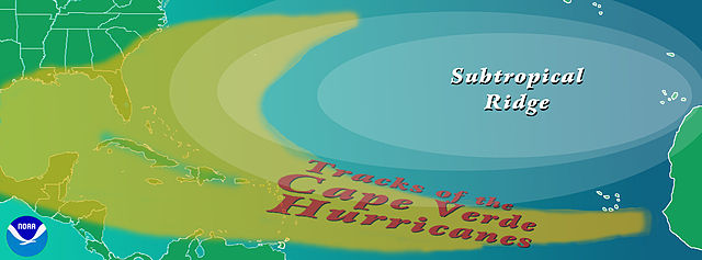
Graphic showing the typical track of a en:Cape Verde-type hurricane. The tracks begin south of en:Cape Verde in the eastern en:Atlantic Ocean.
Copyright statusThe NOAA emblem is the property of the U.S. Government and a trademark of the en:United States Department of Commerce. SourceNOAA graphic from http://www.aoml.noaa.gov/hrd/tcfaq/CVtrak.jpg en:nl:Afbeelding:KaapverdischeOrkanen.jpg |
| Date | 16 July 2004 (original upload date) |
| Source | Transferred from en.wikipedia to Commons by OhanaUnited. |
| Author | The original uploader was Cyrius at English Wikipedia. |
| Other versions |
|
Licensing


This image is in the public domain because it contains materials that originally came from the U.S. National Oceanic and Atmospheric Administration, taken or made as part of an employee's official duties.
|
Original upload log
The original description page was here. All following user names refer to en.wikipedia.
- 2004-07-16 00:36 Cyrius 2550×944×??? (324839 bytes) PD graphic from NOAA
File history
Click on a date/time to view the file as it appeared at that time.
| Date/Time | Thumbnail | Dimensions | User | Comment | |
|---|---|---|---|---|---|
| current | 17:40, 21 August 2008 | 2,550 × 944 (317 KB) | OhanaUnited | {{Information |Description={{en|Graphic showing the typical track of a en:Cape Verde-type hurricane. The tracks begin south of en:Cape Verde in the eastern en:Atlantic Ocean. ==Copyright status== The NOAA emblem is the property of the [[:e |
File usage
The following pages on the English Wikipedia use this file (pages on other projects are not listed):
Global file usage
The following other wikis use this file:
- Usage on ca.wikipedia.org
- Usage on es.wikipedia.org
- Usage on eu.wikipedia.org
- Usage on fr.wikipedia.org
- Usage on it.wikipedia.org
- Usage on ko.wikipedia.org
- Usage on nl.wikipedia.org
- Usage on pt.wikipedia.org
- Usage on uk.wikipedia.org
- Usage on www.wikidata.org