

Original file (960 × 930 pixels, file size: 195 KB, MIME type: image/png)
| This is a file from the Wikimedia Commons. Information from its description page there is shown below. Commons is a freely licensed media file repository. You can help. |
Summary
| Description |
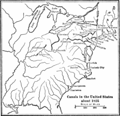
Original Title: 'Canals in the United States about 1825', the map is historically inaccurate, as some parts depicted were not yet built in 1825, although were proposed and funded by the Pennsylvania Legislature as the Main Line of Public Works act of 1824. • Specifically, the Allegheny Portage Railroad across the Allegheny Ridge into Western Pennsylvania would not be begun before 1831 nor completed until 1834. • The depiction of those proposed canals and navigations may be the source material of this map. The Schuylkill Canal was indeed completed in this year, AND 1824 was the start of making the 1818 Lehigh Canal navigations a two way canal. |
| Date | |
| Source | Johnson, Allen (1915). Union and Democracy. Cambridge, Massachusetts: Houghton Mifflin Company. |
| Author | Allen Johnson |
Licensing
|
This work is in the public domain in its country of origin and other countries and areas where the copyright term is the author's life plus 70 years or fewer.
| |
| This file has been identified as being free of known restrictions under copyright law, including all related and neighboring rights. | |
File history
Click on a date/time to view the file as it appeared at that time.
| Date/Time | Thumbnail | Dimensions | User | Comment | |
|---|---|---|---|---|---|
| current | 06:02, 23 April 2007 | | 960 × 930 (195 KB) | SEWilco | {{Information |Description=Areas involved in the Yazoo-Georgia land scandal. |Source=Johnson, Allen (1915). Union and Democracy. Cambridge, Massachusetts: Houghton Mifflin Company. |Date=1915 |Author=Allen Johnson }} |
File usage
Global file usage
The following other wikis use this file:
- Usage on ca.wikipedia.org
- Usage on es.wikipedia.org
- Usage on fr.wikipedia.org
- Usage on ja.wikipedia.org
- Usage on new.wikipedia.org
- Usage on ru.wikipedia.org
- Usage on th.wikipedia.org