

Size of this JPG preview of this TIF file: 753 × 600 pixels. Other resolutions: 302 × 240 pixels | 603 × 480 pixels | 965 × 768 pixels | 1,280 × 1,019 pixels | 2,560 × 2,038 pixels | 5,000 × 3,981 pixels.
Original file (5,000 × 3,981 pixels, file size: 18.99 MB, MIME type: image/tiff)
| This is a file from the Wikimedia Commons. Information from its description page there is shown below. Commons is a freely licensed media file repository. You can help. |
Summary
| CONTEXTUAL VIEW, SHOWING BAY HOUSING, AND BUILDINGS 1 AND 6 FACING SOUTHEAST - Winehaven, Point Molate Naval Fuel Depot, Richmond, Contra Costa County, CA | ||||
|---|---|---|---|---|
| Photographer |
Related names:
|
|||
| Title |
CONTEXTUAL VIEW, SHOWING BAY HOUSING, AND BUILDINGS 1 AND 6 FACING SOUTHEAST - Winehaven, Point Molate Naval Fuel Depot, Richmond, Contra Costa County, CA |
|||
| Depicted place | California; Contra Costa County; Richmond | |||
| Date | Documentation compiled after 1933 | |||
| Dimensions | 4 x 5 in. | |||
| Current location |
Library of Congress Prints and Photographs Division Washington, D.C. 20540 USA http://hdl.loc.gov/loc.pnp/pp.print |
|||
| Accession number |
HABS CAL,7-RICH,2-5 |
|||
| Credit line |
|
|||
| Notes |
|
|||
| References |
|
|||
| Source | https://www.loc.gov/pictures/item/ca2193.photos.324248p | |||
| Permission (Reusing this file) |
|
|||

| Object location | | View this and other nearby images on: OpenStreetMap |
|---|
File history
Click on a date/time to view the file as it appeared at that time.
| Date/Time | Thumbnail | Dimensions | User | Comment | |
|---|---|---|---|---|---|
| current | 23:43, 5 July 2014 | 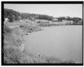 | 5,000 × 3,981 (18.99 MB) | Fæ | GWToolset: Creating mediafile for Fæ. HABS 05 July 2014 (401:500) |
File usage
The following pages on the English Wikipedia use this file (pages on other projects are not listed):
Global file usage
The following other wikis use this file:
- Usage on www.wikidata.org