
Size of this preview: 800 × 409 pixels. Other resolutions: 320 × 163 pixels | 640 × 327 pixels | 1,425 × 728 pixels.
Original file (1,425 × 728 pixels, file size: 52 KB, MIME type: image/png)
| This is a file from the Wikimedia Commons. Information from its description page there is shown below. Commons is a freely licensed media file repository. You can help. |

|
This historical map image could be re-created using vector graphics as an SVG file. This has several advantages; see Commons:Media for cleanup for more information. If an SVG form of this image is available, please upload it and afterwards replace this template with
{{vector version available|new image name}}.
It is recommended to name the SVG file “BritishEmpire1919.svg”—then the template Vector version available (or Vva) does not need the new image name parameter. |
Summary
| Description |
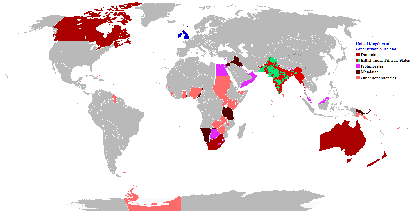
Map of the British Empire in 1919 showing all the territories, including the dominions, colonies, protectorates and mandates, ruled or administered by the United Kingdom and its successor states during that year.
|
| Date | |
| Source |
The following: |
| Author | Maps & Lucy |
| Permission (Reusing this file) |
Released into the public domain (by the author). |
| Other versions | العربيَّة |
Legend
Deutsch (de):
Licensing
This file is licensed under the Creative Commons Attribution-Share Alike 2.5 Generic license.
- You are free:
- to share – to copy, distribute and transmit the work
- to remix – to adapt the work
- Under the following conditions:
- attribution – You must give appropriate credit, provide a link to the license, and indicate if changes were made. You may do so in any reasonable manner, but not in any way that suggests the licensor endorses you or your use.
- share alike – If you remix, transform, or build upon the material, you must distribute your contributions under the same or compatible license as the original.
File history
Click on a date/time to view the file as it appeared at that time.
| Date/Time | Thumbnail | Dimensions | User | Comment | |
|---|---|---|---|---|---|
| current | 08:26, 31 October 2021 | | 1,425 × 728 (52 KB) | Randomastwritter | jubaland |
| 20:43, 17 November 2014 |  | 1,425 × 728 (61 KB) | GrenaderGD44 | Убраны артефакты с карты в районе Антарктиды | |
| 01:40, 17 November 2014 |  | 1,425 × 728 (65 KB) | GrenaderGD44 | Бутан - протекторат с 1910 года | |
| 18:36, 9 March 2014 |  | 1,425 × 625 (39 KB) | Htonl | Bechuanaland, Basutoland and Swaziland were protectorates | |
| 20:02, 18 June 2011 |  | 1,425 × 625 (55 KB) | Maps & Lucy | The British Empire, Mongolia and the Soviet Union all recognized Tibet as an independent state and the British Empire via British India were heavily involved in Tibet's independence. | |
| 19:05, 7 May 2011 |  | 1,425 × 625 (58 KB) | Quigley | Correct China's borders closer to what was internationally recognized at the time | |
| 23:55, 15 December 2010 |  | 1,425 × 625 (55 KB) | Maps & Lucy | Added protectorates and Princely States | |
| 22:47, 10 December 2010 |  | 1,425 × 625 (53 KB) | Maps & Lucy | Papua was a colony not a dominion, Gold Coast did not include British Togoland and British Togoland was a mandate. | |
| 18:20, 7 November 2010 |  | 1,425 × 625 (59 KB) | Spesh531 | fix mistake in botswana | |
| 18:19, 7 November 2010 |  | 1,425 × 625 (56 KB) | Spesh531 | really a way to revert. use this version |
File usage
The following pages on the English Wikipedia use this file (pages on other projects are not listed):
Global file usage
The following other wikis use this file:
- Usage on af.wikipedia.org
- Usage on ar.wikipedia.org
- Usage on azb.wikipedia.org
- Usage on az.wikipedia.org
- Usage on ba.wikipedia.org
- Usage on be-tarask.wikipedia.org
- Usage on be.wikipedia.org
- Usage on bg.wikipedia.org
- Usage on bs.wikipedia.org
- Usage on bxr.wikipedia.org
- Usage on cdo.wikipedia.org
- Usage on de.wikipedia.org
- Usage on el.wikipedia.org
- Usage on eo.wikipedia.org
- Usage on fiu-vro.wikipedia.org
- Usage on fi.wikipedia.org
- Usage on fr.wikipedia.org
- Usage on he.wikipedia.org
- Usage on hif.wikipedia.org
- Usage on hr.wikipedia.org
- Usage on hy.wikipedia.org
- Usage on ia.wikipedia.org
- Usage on id.wikipedia.org
- Usage on is.wikipedia.org
- Usage on ja.wikipedia.org
- Usage on kk.wikipedia.org
- Usage on krc.wikipedia.org
- Usage on lez.wikipedia.org
- Usage on lo.wikipedia.org
- Usage on lv.wikipedia.org
- Usage on ms.wikipedia.org
- Usage on mwl.wikipedia.org
- Usage on my.wikipedia.org
- Usage on nl.wikipedia.org
- Usage on nn.wikipedia.org
- Usage on pnb.wikipedia.org
- Usage on qu.wikipedia.org
- Usage on ru.wikipedia.org
View more global usage of this file.