Original file (7,360 × 3,714 pixels, file size: 156.44 MB, MIME type: image/tiff)
This is a file from the Wikimedia Commons. Information from its description page there is shown below. Commons is a freely licensed media file repository. You can help. |
This file is an original and may be obsolete for general use, but is kept for historical or archival use. As such, it should not be modified or deleted except to correct upload or technical errors. Any modified versions or replacements of this image should be uploaded with a different file name. A version of this file more suitable for general use can be found at File:Bridgeport, California, on the eastern slope of Sierra Mountains, and the county seat of Mono County LCCN2013633802.jpg. العربيَّة ∙ čeština ∙ Deutsch ∙ English ∙ español ∙ فارسی ∙ français ∙ magyar ∙ italiano ∙ 日本語 ∙ Lëtzebuergesch ∙ македонски ∙ മലയാളം ∙ Nederlands ∙ português ∙ русский ∙ slovenščina ∙ svenska ∙ 简体中文 ∙ 繁體中文 ∙ 正體中文(臺灣) ∙ +/− |
Summary
DescriptionBridgeport, California, on the eastern slope of Sierra Mountains, and the county seat of Mono County LCCN2013633802.tif |
Title: Bridgeport, California, on the eastern slope of Sierra Mountains, and the county seat of Mono County
Physical description: 1 photograph : digital, tiff file, color. Notes: Title, date, and keywords provided by the photographer.; Credit line: The Jon B. Lovelace Collection of California Photographs in Carol M. Highsmith's America Project, Library of Congress, Prints and Photographs Division.; Gift; The Capital Group Companies Charitable Foundation in memory of Jon B. Lovelace; 2012; (DLC/PP-2012:063).; Forms part of: Jon B. Lovelace Collection of California Photographs in Carol M. Highsmith's America Project in the Carol M. Highsmith Archive.; Located near the ghost town Bodie on the eastern slope of the Sierra Mountains, it is the county seat of Mono County. Formerly known as Big Meado, the town attracts tourists, many of whom come to the area for well-known trout streams and lakes. |
||||||||||||||||||||||||||
Date | Taken on 23 November 2012, 14:21 (according to Exif data) | ||||||||||||||||||||||||||
Source |
Library of Congress
|
||||||||||||||||||||||||||
Author |
creator QS:P170,Q5044454 |
||||||||||||||||||||||||||
Permission (Reusing this file) |
No known restrictions on publication.
|
||||||||||||||||||||||||||
Other versions |
|
Camera location | 38° 15′ 21.05″ N, 119° 13′ 41.06″ W | View this and other nearby images on: OpenStreetMap | 38.255848; -119.228072 |
---|
Licensing
Public domainPublic domainfalsefalse |
This work is from the Carol M. Highsmith Archive collection at the Library of Congress. According to the library, there are no known copyright restrictions on the use of this work. Carol M. Highsmith has stipulated that her photographs are in the public domain. Photographs of sculpture or other works of art may be restricted by the copyright of the artist; see Commons:FOP US#Artworks and sculptures for more information. |
Items portrayed in this file
depicts
2012
38°15'21.053"N, 119°13'41.059"W
image/tiff
33eba197d277ac0b7b492874897b48c4930c6c57
164,044,406 byte
3,714 pixel
7,360 pixel
File history
Click on a date/time to view the file as it appeared at that time.
Date/Time | Thumbnail | Dimensions | User | Comment | |
---|---|---|---|---|---|
current | 01:09, 4 September 2016 | 
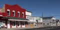
7,360 × 3,714 (156.44 MB) | Fæ | LOC 2013633802, Carol M. Highsmith collection. P1619.9159 TIFF (156.4mb) |
File usage
Metadata
This file contains additional information, probably added from the digital camera or scanner used to create or digitize it.
If the file has been modified from its original state, some details may not fully reflect the modified file.
Image title | Motels in Bridgeport, California.
Bridgeport, California, on the eastern slope of Sierra Mountains, is the county seat of Mono County. It is notable for its proximity to the well-preserved ghost town of Bodie. Formerly known as Big Meadows, Bridgeport is annually visited by thousands of tourists, many of whom come to the area for its well-known trout streams and lakes. |
---|---|
Camera manufacturer | NIKON CORPORATION |
Camera model | NIKON D800E |
Author | Photographer: Carol M. Highsmith |
Exposure time | 1/400 sec (0.0025) |
F-number | f/10 |
ISO speed rating | 100 |
Date and time of data generation | 14:21, 23 November 2012 |
Lens focal length | 35 mm |
Latitude | 38° 15′ 21.05″ N |
Longitude | 119° 13′ 41.06″ W |
Altitude | 1,974 meters above sea level |
Width | 7,360 px |
Height | 3,714 px |
Bits per component |
|
Compression scheme | Uncompressed |
Pixel composition | RGB |
Image data location | 30,606 |
Orientation | Normal |
Number of components | 3 |
Number of rows per strip | 3,714 |
Bytes per compressed strip | 164,010,240 |
Horizontal resolution | 300 dpi |
Vertical resolution | 300 dpi |
Data arrangement | chunky format |
Software used | Ver.1.00 |
File change date and time | 00:12, 2 December 2012 |
Exposure Program | Manual |
Exif version | 2.21 |
Date and time of digitizing | 14:21, 23 November 2012 |
Shutter speed | 8.643856 |
APEX aperture | 6.643856 |
Exposure bias | −1.3333333333333 |
Maximum land aperture | 3 APEX (f/2.83) |
Metering mode | Pattern |
Light source | Unknown |
Flash | Flash did not fire, compulsory flash suppression |
DateTimeOriginal subseconds | 3 |
Color space | Uncalibrated |
Focal plane X resolution | 204.84020996094 |
Focal plane Y resolution | 204.84020996094 |
Focal plane resolution unit | 4 |
Sensing method | One-chip color area sensor |
File source | Digital still camera |
Scene type | A directly photographed image |
Custom image processing | Normal process |
Exposure mode | Manual exposure |
White balance | Auto white balance |
Digital zoom ratio | 1 |
Focal length in 35 mm film | 35 mm |
Scene capture type | Standard |
Scene control | None |
Contrast | Normal |
Saturation | Normal |
Sharpness | Normal |
Subject distance range | Unknown |
GPS time (atomic clock) | 21:21 |
Satellites used for measurement | 08 |
Geodetic survey data used | WGS 84 |
GPS date | 23 November 2012 |
GPS tag version | 2.3.0.0 |