

Size of this preview: 800 × 450 pixels. Other resolutions: 320 × 180 pixels | 640 × 360 pixels | 1,024 × 576 pixels | 1,280 × 720 pixels | 2,816 × 1,584 pixels.
Original file (2,816 × 1,584 pixels, file size: 1.81 MB, MIME type: image/jpeg)
| This is a file from the Wikimedia Commons. Information from its description page there is shown below. Commons is a freely licensed media file repository. You can help. |
|
This is an image of a place or building that is listed on the National Register of Historic Places in the United States of America. Its reference number is 85001166. |
| Camera location | | View this and other nearby images on: OpenStreetMap |
|---|
| Description |
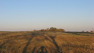
Western edge of the Bono Archaeological Site, located on the eastern side of Bono-Tunnelton Road above the East Fork of the White River and one mile north of Bono in Bono Township, Lawrence County, Indiana, United States. Most of the field is a clam shell midden and thus a valuable archaeological site; it is listed on the National Register of Historic Places. |
||
| Date | Taken on 8 October 2011 | ||
| Source | Own work | ||
| Author | Nyttend | ||
| Permission (Reusing this file) |
|
File history
Click on a date/time to view the file as it appeared at that time.
| Date/Time | Thumbnail | Dimensions | User | Comment | |
|---|---|---|---|---|---|
| current | 12:27, 9 October 2011 | | 2,816 × 1,584 (1.81 MB) | Nyttend | {{Location|38|44|42|N|86|19|54|W}} {{Information |Description={{en|Western edge of the {{w|Bono Archaeological Site}}, located on the eastern side of Bono-Tunnelton Road above the East Fork of the {{w|White River (Indiana)|White River}} and one mile north |
File usage
The following pages on the English Wikipedia use this file (pages on other projects are not listed):
Global file usage
The following other wikis use this file:
- Usage on es.wikipedia.org
- Usage on eu.wikipedia.org
- Usage on ur.wikipedia.org
- Usage on vi.wikipedia.org
- Usage on www.wikidata.org
- Usage on zh.wikipedia.org