

Size of this JPG preview of this PDF file: 800 × 566 pixels. Other resolutions: 320 × 226 pixels | 640 × 453 pixels | 1,024 × 724 pixels | 1,280 × 905 pixels | 1,752 × 1,239 pixels.
Original file (1,752 × 1,239 pixels, file size: 124 KB, MIME type: application/pdf)
| This is a file from the Wikimedia Commons. Information from its description page there is shown below. Commons is a freely licensed media file repository. You can help. |

|
This graph image could be re-created using vector graphics as an SVG file. This has several advantages; see Commons:Media for cleanup for more information. If an SVG form of this image is available, please upload it and afterwards replace this template with
{{vector version available|new image name}}.
It is recommended to name the SVG file “Bevölkerungsentwicklung FrankfurtOder.svg”—then the template Vector version available (or Vva) does not need the new image name parameter. |
Summary
| Description |
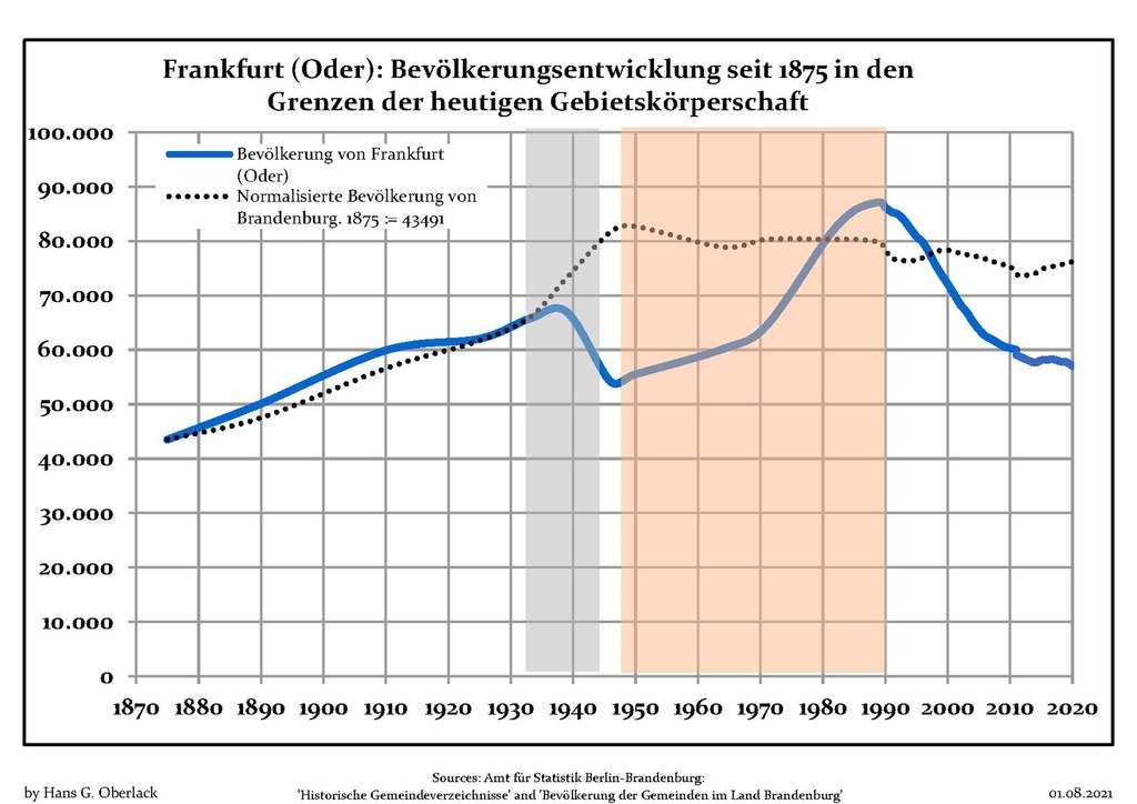
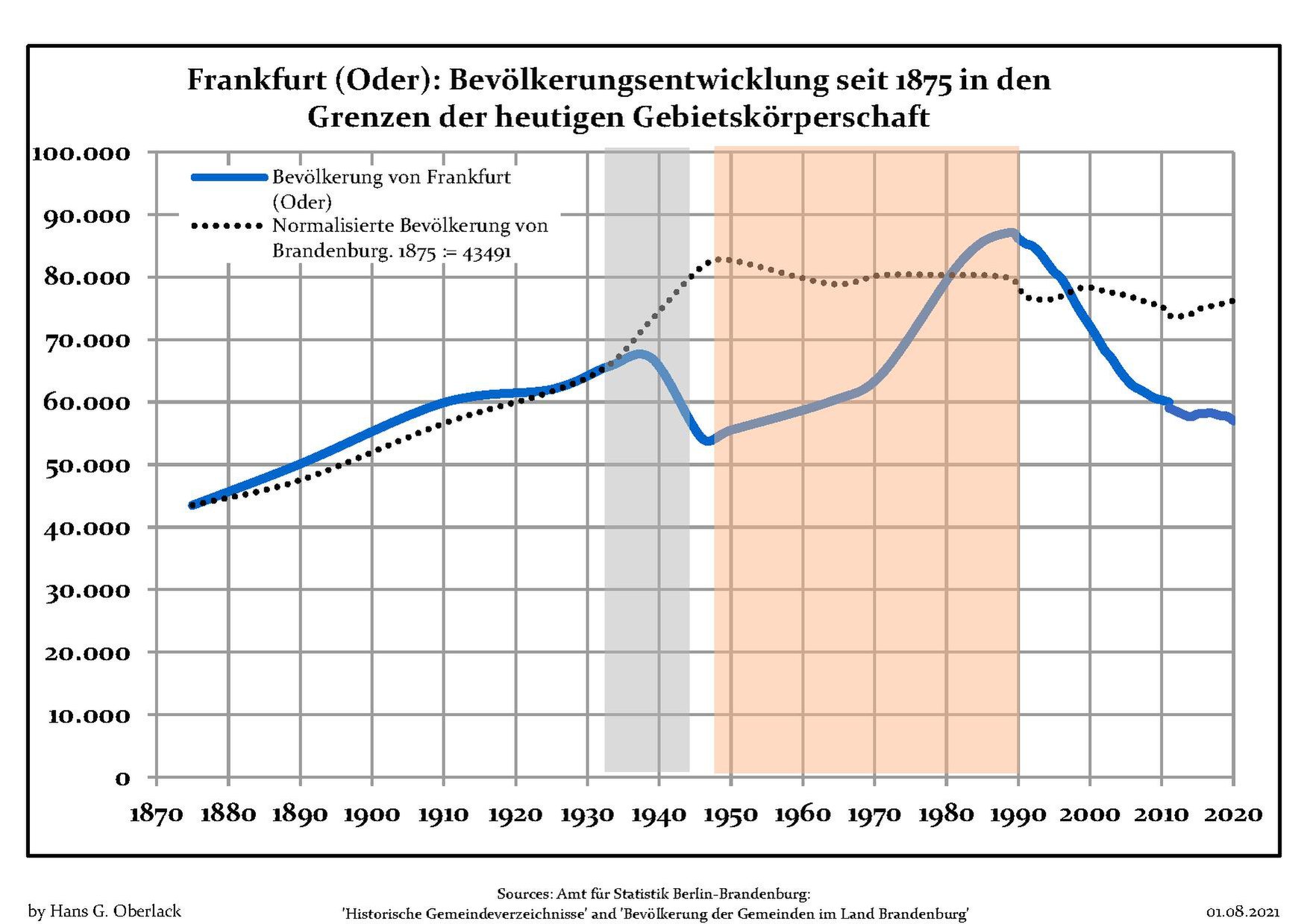
Population development within the current boundaries of Frankfurt (Oder), Frankfurt (Oder) district, Brandenburg state, Germany
Blue line: Population -- Dotted line: Comparison to population development of Brandenburg state Grey background: Time of nazi rule -- Red background: Time of communist rule |
| Date | between 9 April 2012 and 1 August 2021 |
| Source | Own work based on: Data sources displayed at Population Projection Brandenburg at Wikimedia Commons |
| Author | Hans G. Oberlack |
| Latest population data | 2020 |
| Object location | | View this and other nearby images on: OpenStreetMap |
|---|
Licensing
I, the copyright holder of this work, hereby publish it under the following license:
This file is licensed under the Creative Commons Attribution-Share Alike 3.0 Unported license.
- You are free:
- to share – to copy, distribute and transmit the work
- to remix – to adapt the work
- Under the following conditions:
- attribution – You must give appropriate credit, provide a link to the license, and indicate if changes were made. You may do so in any reasonable manner, but not in any way that suggests the licensor endorses you or your use.
- share alike – If you remix, transform, or build upon the material, you must distribute your contributions under the same or compatible license as the original.
File history
Click on a date/time to view the file as it appeared at that time.
| Date/Time | Thumbnail | Dimensions | User | Comment | |
|---|---|---|---|---|---|
| current | 23:07, 31 July 2021 |  | 1,752 × 1,239 (124 KB) | Hans G. Oberlack | 2017, 2018, 2019, 2020 data added |
| 12:06, 14 January 2017 |  | 1,752 × 1,239 (121 KB) | Hans G. Oberlack | 2015 data added | |
| 18:15, 14 June 2015 |  | 1,752 × 1,239 (98 KB) | Hans G. Oberlack | Graphics adjusted to recent data | |
| 23:23, 27 July 2013 |  | 1,752 × 1,239 (99 KB) | Hans G. Oberlack | Comparison to development of total population of Brandenburg state added | |
| 21:21, 9 April 2012 |  | 1,752 × 1,239 (96 KB) | Hans G. Oberlack |
File usage
The following pages on the English Wikipedia use this file (pages on other projects are not listed):
Global file usage
The following other wikis use this file:
- Usage on be.wikipedia.org
- Usage on es.wikipedia.org
- Usage on fr.wikipedia.org
- Usage on nl.wikipedia.org
- Usage on ru.wikipedia.org
- Usage on sv.wikipedia.org