

Size of this preview: 621 × 600 pixels. Other resolutions: 249 × 240 pixels | 497 × 480 pixels | 795 × 768 pixels | 1,061 × 1,024 pixels | 1,800 × 1,738 pixels.
Original file (1,800 × 1,738 pixels, file size: 978 KB, MIME type: image/png)
| This is a file from the Wikimedia Commons. Information from its description page there is shown below. Commons is a freely licensed media file repository. You can help. |
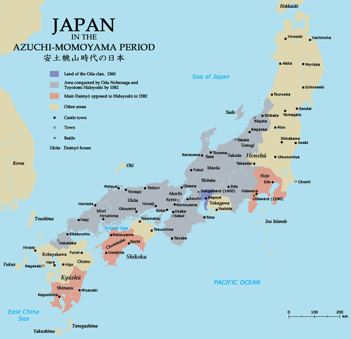
| Description | Map of Japan in the Azuchi-Momoyama period. | ||||||||||||
| Date | |||||||||||||
| Source | Self-made; base map from Demis MapClip; all information from The Cassell Atlas of World History by John Haywood et al. (Cassell 1997) | ||||||||||||
| Author | Zakuragi | ||||||||||||
| Permission (Reusing this file) |
I, the copyright holder of this work, hereby publish it under the following licenses:
This file is licensed under the Creative Commons Attribution-Share Alike 2.5 Generic, 2.0 Generic and 1.0 Generic license.
You may select the license of your choice.
|


|
This historical map image could be re-created using vector graphics as an SVG file. This has several advantages; see Commons:Media for cleanup for more information. If an SVG form of this image is available, please upload it and afterwards replace this template with
{{vector version available|new image name}}.
It is recommended to name the SVG file “Azuchimomoyama-japan.svg”—then the template Vector version available (or Vva) does not need the new image name parameter. |
File history
Click on a date/time to view the file as it appeared at that time.
| Date/Time | Thumbnail | Dimensions | User | Comment | |
|---|---|---|---|---|---|
| current | 19:53, 23 August 2022 | | 1,800 × 1,738 (978 KB) | Artanisen | Higher quality version of the map |
| 19:30, 9 July 2007 |  | 930 × 898 (102 KB) | Tonym88~commonswiki | {{Information |Description= Map of Japan in the Azuchi-Momoyama period. |Source= Self-made; base map from [http://www.demis.nl/wms/mapclip.htm Demis MapClip]; all information from ''The Cassell Atlas of World History'' by John Haywood ''et al.'' (Cassell |
File usage
The following pages on the English Wikipedia use this file (pages on other projects are not listed):
Global file usage
The following other wikis use this file:
- Usage on ba.wikipedia.org
- Usage on be.wikipedia.org
- Usage on ca.wikipedia.org
- Usage on cs.wikipedia.org
- Usage on de.wikipedia.org
- Usage on fa.wikipedia.org
- Usage on fr.wikipedia.org
- Usage on glk.wikipedia.org
- Usage on hr.wikipedia.org
- Usage on hu.wikipedia.org
- Usage on id.wikipedia.org
- Usage on it.wikipedia.org
- Usage on nl.wikipedia.org
- Usage on no.wikipedia.org
- Usage on pl.wikipedia.org
- Usage on ro.wikipedia.org
- Usage on ru.wikipedia.org
- Usage on sh.wikipedia.org
- Usage on sk.wikipedia.org
- Usage on sl.wikipedia.org
- Usage on sq.wikipedia.org
- Usage on sr.wikipedia.org
- Usage on th.wikipedia.org
- Usage on tl.wikipedia.org
- Usage on vi.wikipedia.org
- Usage on zh.wikipedia.org