
_jpg)

Size of this preview: 799 × 599 pixels. Other resolutions: 320 × 240 pixels | 640 × 480 pixels | 881 × 661 pixels.
Original file (881 × 661 pixels, file size: 78 KB, MIME type: image/jpeg)
| This is a file from the Wikimedia Commons. Information from its description page there is shown below. Commons is a freely licensed media file repository. You can help. |
.jpg)
|
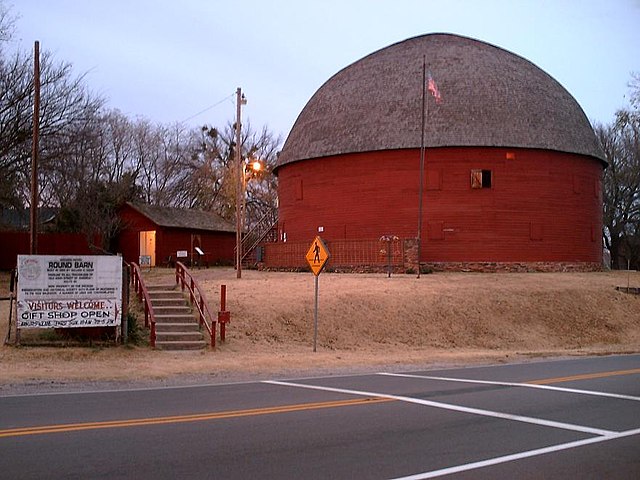
This is an image of a place or building that is listed on the National Register of Historic Places in the United States of America. Its reference number is 77001094. |
Summary
| Description |
The Arcadia Round Barn is a site on the National Register of Historic Places and is located in Arcadia on Route 66. This photo was taken on the south side of Route 66 looking north. |
| Date | Taken on 19 November 2005 |
| Source | Transferred from en.wikipedia |
| Author | DBinfo at en.wikipedia |
| Object location | | View this and other nearby images on: OpenStreetMap |
|---|
.jpg¶ms=035.662222_N_-097.325556_E_globe:Earth_class:object_region:US_type:landmark_scale:1500_&language=en)
Licensing
| This work has been released into the public domain by its author, DBinfo at English Wikipedia. This applies worldwide. In some countries this may not be legally possible; if so: DBinfo grants anyone the right to use this work for any purpose, without any conditions, unless such conditions are required by law. |
Original upload log
The original description page was here. All following user names refer to en.wikipedia.
- 2006-04-30 05:27 DBinfo 881×661×8 (80172 bytes) The [[Arcadia Round Barn]] is a site on the [[National Register of Historic Places]] and is located in [[Arcadia, OK]] on [[Route 66]]. This photo was taken on the south side of Route 66 looking north on [[November 19, 2005]].
File history
Click on a date/time to view the file as it appeared at that time.
| Date/Time | Thumbnail | Dimensions | User | Comment | |
|---|---|---|---|---|---|
| current | 20:37, 8 May 2008 | | 881 × 661 (78 KB) | File Upload Bot (Magnus Manske) | {{BotMoveToCommons|en.wikipedia}} {{Information |Description={{en|The en:Arcadia Round Barn is a site on the en:National Register of Historic Places and is located in en:Arcadia, OK on en:Route 66. This photo was taken on the south s |
File usage
The following pages on the English Wikipedia use this file (pages on other projects are not listed):
Global file usage
The following other wikis use this file:
- Usage on ar.wikipedia.org
- Usage on arz.wikipedia.org
- Usage on azb.wikipedia.org
- Usage on ca.wikipedia.org
- Usage on ceb.wikipedia.org
- Usage on ce.wikipedia.org
- Usage on de.wikipedia.org
- Usage on en.wikivoyage.org
- Usage on es.wikipedia.org
- Usage on eu.wikipedia.org
- Usage on fa.wikipedia.org
- Usage on fr.wikipedia.org
- Usage on ht.wikipedia.org
- Usage on it.wikipedia.org
- Usage on it.wikivoyage.org
- Usage on ky.wikipedia.org
- Usage on lld.wikipedia.org
- Usage on pl.wikipedia.org
- Usage on pt.wikipedia.org
- Usage on ro.wikipedia.org
- Usage on sh.wikipedia.org
- Usage on simple.wikipedia.org
- Usage on sr.wikipedia.org
- Usage on sv.wikipedia.org
- Usage on tr.wikipedia.org
- Usage on tt.wikipedia.org
- Usage on uk.wikipedia.org
- Usage on ur.wikipedia.org
- Usage on uz.wikipedia.org
- Usage on www.wikidata.org
- Usage on zh-min-nan.wikipedia.org
.jpg)