
Original file (600 × 616 pixels, file size: 59 KB, MIME type: image/jpeg)
| This is a file from the Wikimedia Commons. Information from its description page there is shown below. Commons is a freely licensed media file repository. You can help. |
Summary

|
This historical map image could be re-created using vector graphics as an SVG file. This has several advantages; see Commons:Media for cleanup for more information. If an SVG form of this image is available, please upload it and afterwards replace this template with
{{vector version available|new image name}}.
It is recommended to name the SVG file “Alignment Official Pakistan map 1962.svg”—then the template Vector version available (or Vva) does not need the new image name parameter. |


| Description |
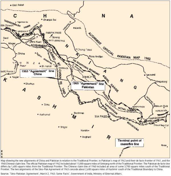
Map depicting the official alignment of the northern border of Kashmir in 1962 according to the Government of Pakistan |
| Date | |
| Source | Sino Pakistan "Agreement", March 2, 1963 "Some facts" published by the Government of India, Ministry of External Affairs |
| Author | The Government of India, Ministry of External Affairs |
| Camera location | | View this and other nearby images on: OpenStreetMap |
|---|
The area pertains to the Cis-Kuen Lun Tract in northern Kashmir, the area in northern Kashmir which has been either annexed by the Chinese or is part of the area ceded by Pakistan to the Chinese. The Northern border of the Cis-Kuen Lun Tract is the area of Dafdar in the area of the Taghdumbash Pamir and Mariom Pamir and the mountain passes in northern Kashmir including inter alia the Kukalang Pass, Yangi Pass to the north of the Raskam area in Kanjut , the Kilian Pass, the Sanju-La Pass and the Hindutash Pass. The Government of Pakistan had published an official map depicting the alignment of the northern Border of Kashmir in 1962 which depicted much of the Cis-Kuen Lun Tract as part of Kashmir and the Times Atlas had predominantly depicted the Cis-Kuen Lun Tract as a part of Kashmir under the caption "Undefined Frontier area" in 1959.
Licensing
This work is in the public domain in India because its term of copyright has expired.
The Indian Copyright Act applies in India to works first published in India. According to the Indian Copyright Act, 1957, as amended up to Act No. 27 of 2012 (Chapter V, Section 25):
|
 |
– India public domain images and sounds, 60 years after the end of the year of first publication, The subject matter of the photo or recording is also not protected by copyright.
File history
Click on a date/time to view the file as it appeared at that time.
| Date/Time | Thumbnail | Dimensions | User | Comment | |
|---|---|---|---|---|---|
| current | 13:56, 21 April 2016 | | 600 × 616 (59 KB) | Hindutashravi | User created page with UploadWizard |
File usage
Global file usage
The following other wikis use this file:
- Usage on ja.wikipedia.org
- Usage on pl.wikipedia.org
- Usage on te.wikipedia.org