

Size of this preview: 515 × 600 pixels. Other resolutions: 206 × 240 pixels | 412 × 480 pixels | 742 × 864 pixels.
Original file (742 × 864 pixels, file size: 542 KB, MIME type: image/jpeg)
| This is a file from the Wikimedia Commons. Information from its description page there is shown below. Commons is a freely licensed media file repository. You can help. |
| Description |
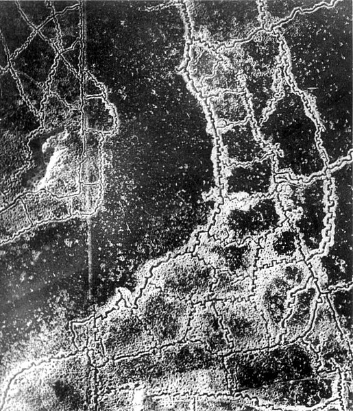
An aerial reconnaissance photograph of the opposing trenches and no-man's land between Loos-en-Gohelle and Hulluch in Artois, France, taken at 7.15 pm, 22 July 1917. German trenches are at the right and bottom, British trenches are at the top left. The vertical line to the left of centre indicates the course of a pre-war road or track.
The location is Hill 70, attacked and taken between 15 and 25 August 1917 by the Canadian Corps. |
|||
| Date | ||||
| Source |
|
|||
| Author | Unknown author | |||
| Permission (Reusing this file) |
|


| Camera location | | View this and other nearby images on: OpenStreetMap |
|---|
Note: Location is approximate.

|
This image has been assessed under the valued image criteria and is considered the most valued image on Commons within the scope: World War I trench systems, aerial view. You can see its nomination here. |
File history
Click on a date/time to view the file as it appeared at that time.
| Date/Time | Thumbnail | Dimensions | User | Comment | |
|---|---|---|---|---|---|
| current | 03:12, 16 January 2012 | | 742 × 864 (542 KB) | Centpacrr | Remove text. |
| 05:49, 10 December 2005 |  | 767 × 864 (243 KB) | Gsl~commonswiki | {{PD-BritishGov}} |
File usage
The following pages on the English Wikipedia use this file (pages on other projects are not listed):
Global file usage
The following other wikis use this file:
- Usage on ast.wikipedia.org
- Usage on az.wikipedia.org
- Usage on be-tarask.wikipedia.org
- Usage on be.wikipedia.org
- Usage on bg.wikipedia.org
- Usage on br.wikipedia.org
- Usage on ca.wikipedia.org
- Usage on da.wikipedia.org
- Usage on de.wikipedia.org
- Usage on es.wikipedia.org
- Usage on et.wikipedia.org
- Usage on fa.wikipedia.org
- Usage on fi.wikipedia.org
- Usage on fr.wikipedia.org
- Usage on fr.wikiversity.org
- Usage on gl.wikipedia.org
- Usage on hu.wikipedia.org
- Usage on hy.wikipedia.org
- Usage on id.wikipedia.org
- Usage on it.wikipedia.org
- Usage on it.wikiquote.org
- Usage on ja.wikipedia.org
- Usage on ko.wikipedia.org
- Usage on ml.wikipedia.org
- Usage on ms.wikipedia.org
- Usage on nl.wikipedia.org
- Usage on nl.wiktionary.org
- Usage on no.wikipedia.org
- Usage on oc.wikipedia.org
- Usage on pcd.wikipedia.org
- Usage on pl.wikipedia.org
- Usage on pt.wikipedia.org
- Usage on ro.wikipedia.org
- Usage on ru.wikipedia.org
View more global usage of this file.