

Size of this preview: 800 × 538 pixels. Other resolutions: 320 × 215 pixels | 640 × 431 pixels | 1,024 × 689 pixels | 1,280 × 861 pixels | 2,560 × 1,723 pixels | 12,717 × 8,557 pixels.
Original file (12,717 × 8,557 pixels, file size: 13.17 MB, MIME type: image/jpeg)
| This is a file from the Wikimedia Commons. Information from its description page there is shown below. Commons is a freely licensed media file repository. You can help. |
Summary
| Warning | The original file is very high-resolution. It might not load properly or could cause your browser to freeze when opened at full size. |
|---|
| Description |
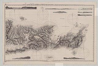
Nautical chart of the eastern part of Crete, Greece. Surveyed by Capt. T. Spratt Lieut. A. Mansell J. Stokes Master, G.R. Wilkinson Mate, & E.W.B. Brooker 2nd Master, H.M.S. Spitfire 1852. Not current - not to be used for navigation! |
||||||||||
| Date | |||||||||||
| Source | https://collections.lib.uwm.edu/digital/collection/agdm/id/8791/rec/261 | ||||||||||
| Author |
|
||||||||||
Licensing
This work created by the United Kingdom Government is in the public domain.
This is because it is one of the following:
HMSO has declared that the expiry of Crown Copyrights applies worldwide (ref: HMSO Email Reply)
|
 |
File history
Click on a date/time to view the file as it appeared at that time.
| Date/Time | Thumbnail | Dimensions | User | Comment | |
|---|---|---|---|---|---|
| current | 21:36, 23 November 2019 | | 12,717 × 8,557 (13.17 MB) | Kognos | User created page with UploadWizard |
File usage
The following pages on the English Wikipedia use this file (pages on other projects are not listed):