

Size of this JPG preview of this TIF file: 692 × 599 pixels. Other resolutions: 277 × 240 pixels | 554 × 480 pixels | 887 × 768 pixels | 1,182 × 1,024 pixels | 2,364 × 2,048 pixels | 4,932 × 4,272 pixels.
Original file (4,932 × 4,272 pixels, file size: 60.29 MB, MIME type: image/tiff)
| This is a file from the Wikimedia Commons. Information from its description page there is shown below. Commons is a freely licensed media file repository. You can help. |
Summary
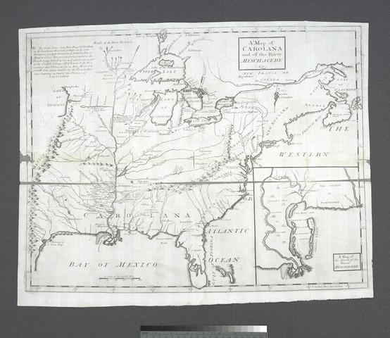
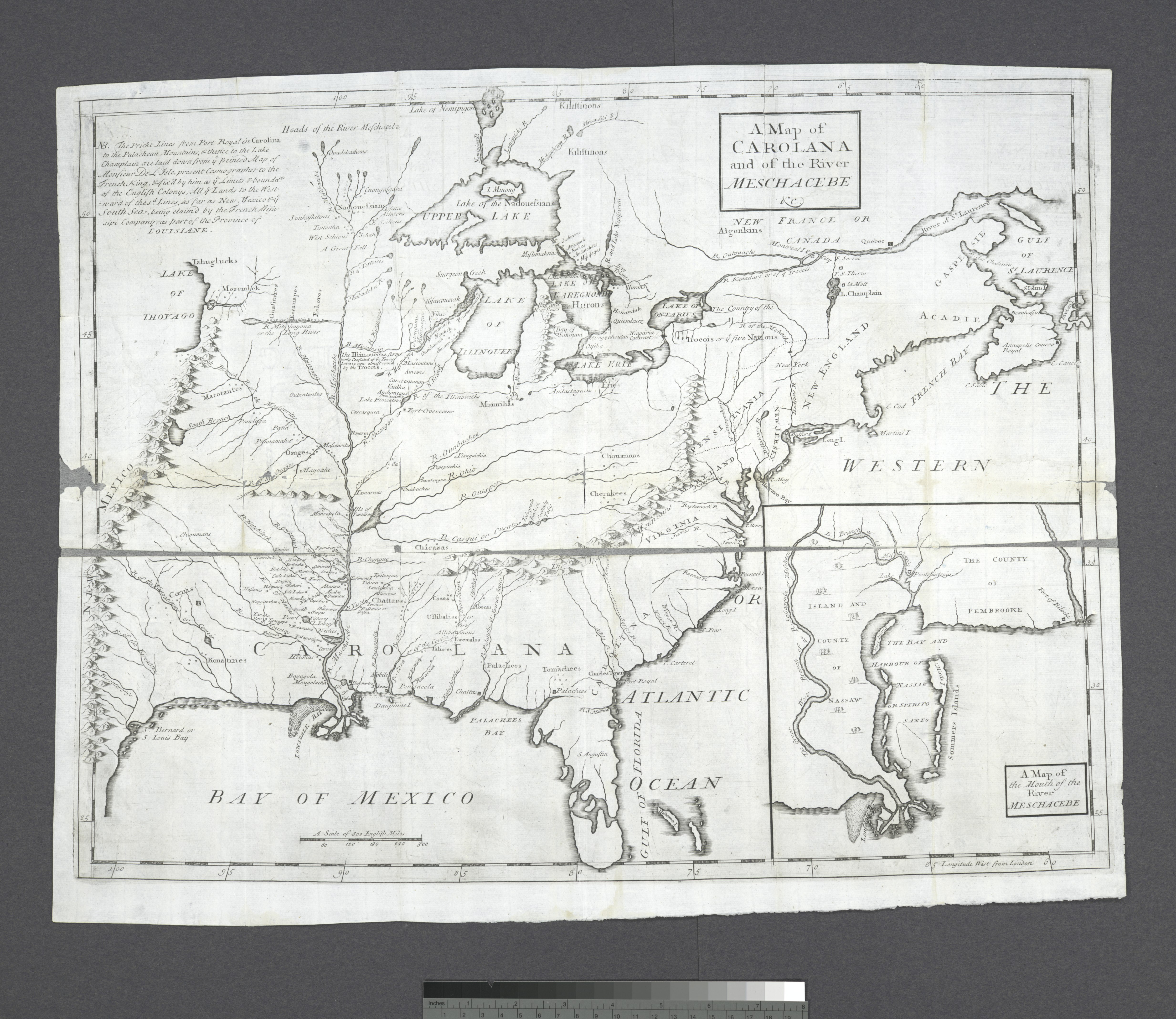
| Description | A Map of Carolana and of the River Meschacebe etc; Lawrence H. Slaughter Collection of English maps, charts, globes, books and atlases / Charts and maps | |||||||||||||||||||||||
| Notes | Appears in Coxe's Description of the English province of Carolana, 1722 and later eds. ''Note 2.'') Covers U.S. as far west as the Rocky Mountains. ''Note 3.'') Includes notes. ''Note 4.'') Inset: Map of the mouth of the River Meschacebe. ''Note 5.'') Lawrence H. Slaughter Collection ; 543. ''Note 6.'') National Endowment for the Humanities Grant for Access to Early Maps of the Middle Atlantic Seaboard. ''Note 7.'') Prime meridian London. ''Note 8.'') Relief shown pictorially. | |||||||||||||||||||||||
| Catalogue call number | Map Div. 97-6148 [LHS 543] | |||||||||||||||||||||||
| Standard reference | Cumming, W.P. Southeast in early maps, 190 | |||||||||||||||||||||||
| Date | circa 1722 | |||||||||||||||||||||||
| Source |
http://digitalgallery.nypl.org/nypldigital/dgkeysearchdetail.cfm?imageID=434393
|
|||||||||||||||||||||||
| Author | ||||||||||||||||||||||||
| Permission (Reusing this file) |
From The Lionel Pincus and Princess Firyal Map Division. http://maps.nypl.org
|
|||||||||||||||||||||||
| Location | Stephen A. Schwarzman Building / The Lionel Pincus and Princess Firyal Map Division | |||||||||||||||||||||||
| Digital item published | 9-21-2004; updated 3-25-2011 | |||||||||||||||||||||||
| Digital ID | 434393 | |||||||||||||||||||||||

The making of this file was supported by Wikimedia UK.
To see other files made with the support of Wikimedia UK, please see the category Supported by Wikimedia UK.
|
File history
Click on a date/time to view the file as it appeared at that time.
| Date/Time | Thumbnail | Dimensions | User | Comment | |
|---|---|---|---|---|---|
| current | 10:22, 20 April 2014 |  | 4,932 × 4,272 (60.29 MB) | Fæ | GWToolset:: Creating mediafile for Fæ. Tranche 2.590 |
File usage
No pages on the English Wikipedia use this file (pages on other projects are not listed).
Global file usage
The following other wikis use this file:
- Usage on ceb.wikipedia.org