

Original file (1,401 × 634 pixels, file size: 38 KB, MIME type: image/png)
| This is a file from the Wikimedia Commons. Information from its description page there is shown below. Commons is a freely licensed media file repository. You can help. |

|
This graph image could be re-created using vector graphics as an SVG file. This has several advantages; see Commons:Media for cleanup for more information. If an SVG form of this image is available, please upload it and afterwards replace this template with
{{vector version available|new image name}}.
It is recommended to name the SVG file “30 highest peaks with more than 500m prominence.svg”—then the template Vector version available (or Vva) does not need the new image name parameter. |
Summary
| Description |
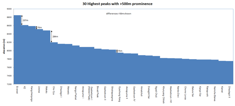
Bar graph of the 30 highest peaks with labels showing height differences greater than 50m. |
| Date | |
| Source | Own work |
| Author | Wikimedes |
Heights from Wikipedia List of highest mountains (http://en.wikipedia.org/wiki/List_of_highest_mountains) retrieved in Feb 2012. The article's sources for heights are: For Nepal, the heights indicated on the Nepal Topographic Maps are followed. For China and the Baltoro Karakoram, the heights are those of "The Maps of Snow Mountains in China". For the Hispar Karakoram the heights on a Russian 1:100,000 topo map [1] seem to be more accurate than the customarily quoted heights probably based on US army maps from the 50s [2]. Elsewhere, unless otherwise indicated, heights are those in Jill Neate's "High Asia".
Licensing
- You are free:
- to share – to copy, distribute and transmit the work
- to remix – to adapt the work
- Under the following conditions:
- attribution – You must give appropriate credit, provide a link to the license, and indicate if changes were made. You may do so in any reasonable manner, but not in any way that suggests the licensor endorses you or your use.
- share alike – If you remix, transform, or build upon the material, you must distribute your contributions under the same or compatible license as the original.
File history
Click on a date/time to view the file as it appeared at that time.
| Date/Time | Thumbnail | Dimensions | User | Comment | |
|---|---|---|---|---|---|
| current | 07:04, 22 March 2012 | | 1,401 × 634 (38 KB) | Wikimedes |
File usage
Global file usage
The following other wikis use this file:
- Usage on da.wikipedia.org
- Usage on el.wikipedia.org
- Usage on ml.wikipedia.org
- Usage on ms.wikipedia.org
- Usage on uk.wikipedia.org