

Size of this preview: 756 × 600 pixels. Other resolutions: 303 × 240 pixels | 605 × 480 pixels | 969 × 768 pixels | 1,280 × 1,015 pixels | 2,560 × 2,030 pixels | 4,000 × 3,172 pixels.
Original file (4,000 × 3,172 pixels, file size: 4 MB, MIME type: image/jpeg)
| This is a file from the Wikimedia Commons. Information from its description page there is shown below. Commons is a freely licensed media file repository. You can help. |
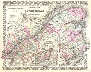
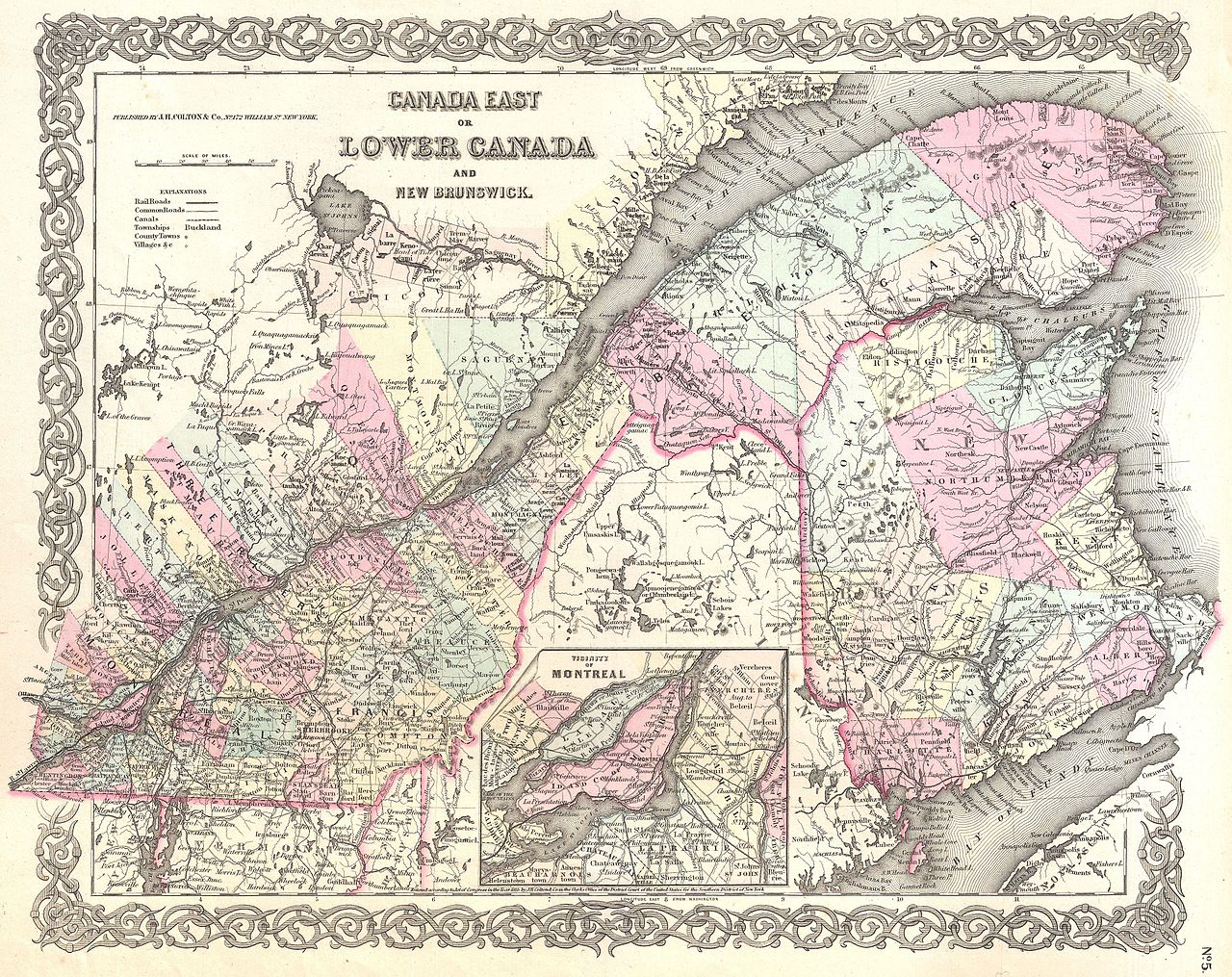
| J. H. Colton: Canada East or Lower Canada and New Brunswick.
( |
|||||||||||||||||||||
|---|---|---|---|---|---|---|---|---|---|---|---|---|---|---|---|---|---|---|---|---|---|
| Artist |
|
||||||||||||||||||||
| Title |
Canada East or Lower Canada and New Brunswick. |
||||||||||||||||||||
| Description |
English: An excellent first edition example of Colton's rare map of Quebec and New Brunswick. Covers what at the time was called Lower or East Canada from Montreal in the southwest to the mouth of the St. Lawrence River in the northwest. Includes the province of New Brunswick. Throughout the map Colton identifies various cities, towns, forts, rivers, rapids, fords, and an assortment of additional topographical details. Map is hand colored in pink, green, yellow and blue pastels to define national and regional boundaries. Surrounded by Colton's typical spiral motif border. Dated and copyrighted to J. H. Colton, 1855. Published as page no. 5 in volume 1 of the first edition of George Washington Colton's 1855 Atlas of the World . |
||||||||||||||||||||
| Date | 1855 (dated) | ||||||||||||||||||||
| Dimensions | height: 13 in (33 cm); width: 16 in (40.6 cm) | ||||||||||||||||||||
| Accession number |
Geographicus link: Quebec-colton-1855 |
||||||||||||||||||||
| Source/Photographer |
Colton, G. W., Colton's Atlas of the World Illustrating Physical and Political Geography, Vol 1, New York, 1855 (First Edition).
|
||||||||||||||||||||
| Permission (Reusing this file) |
|
||||||||||||||||||||

File history
Click on a date/time to view the file as it appeared at that time.
| Date/Time | Thumbnail | Dimensions | User | Comment | |
|---|---|---|---|---|---|
| current | 12:43, 23 March 2011 | | 4,000 × 3,172 (4 MB) | BotMultichillT | {{subst:User:Multichill/Geographicus |link=http://www.geographicus.com/P/AntiqueMap/Quebec-colton-1855 |product_name=1855 Colton Map of Canada East or Quebec |map_title=Canada East or Lower Canada and New Brunswick. |description=An excellent first edition |
File usage
The following pages on the English Wikipedia use this file (pages on other projects are not listed):
Global file usage
The following other wikis use this file:
- Usage on fr.wikipedia.org
- Usage on www.wikidata.org