

Original file (7,721 × 5,171 pixels, file size: 24.3 MB, MIME type: image/jpeg)
| This is a file from the Wikimedia Commons. Information from its description page there is shown below. Commons is a freely licensed media file repository. You can help. |
Summary
| Description |
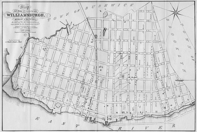
Map of the Village of Williamsburgh, Kings County; As laid out by the Commissioners, appointed by the Legislature in 1827. Reduced from the large Map in the possession of the Trustees of the Village. Surveyed by D. Ewin. New York, Engraved & Published by H. McDowell, 1833.
The Bushwick Creek, which originally separated Williamsburg from Greenpoint, has since been filled in. Today, much of the filled in land along Bushwick Creek makes up McCarren Park. Bushwick Inlet still exists near N 13th and N 14th Streets. Streets names on the map and their modern day names: Turnpike Road to Jamaica => Metropolitan Ave Water Street => River Street First Street => Kent Ave Second Street => Wythe Ave Third Street => Berry Street Fourth Street => Bedford Ave Fifth Street => Driggs Ave Sixth Street => Roebling Street Seventh Street => Havemeyer Street Eighth Street => Marcy Ave Ninth Street => Rodney Street Tenth Street => Keap Street |
| Date | |
| Source | Self-scanned |
| Author | H. McDowell |
| Permission (Reusing this file) |
public domain |
Licensing
|
This work is in the public domain in its country of origin and other countries and areas where the copyright term is the author's life plus 70 years or fewer.
| |
| This file has been identified as being free of known restrictions under copyright law, including all related and neighboring rights. | |
File history
Click on a date/time to view the file as it appeared at that time.
| Date/Time | Thumbnail | Dimensions | User | Comment | |
|---|---|---|---|---|---|
| current | 15:40, 9 March 2009 | | 7,721 × 5,171 (24.3 MB) | Repliedthemockturtle | {{Information |Description={{en|1=A Map of the Village of Williamsburg, Kings County, NY, showing each lot of ground in said village, as laid on the assessment maps of the village, together with the new assessment number of each lot. The village is divid |
File usage
Global file usage
The following other wikis use this file:
- Usage on da.wikipedia.org
- Usage on ja.wikipedia.org