

Size of this preview: 640 × 600 pixels. Other resolutions: 256 × 240 pixels | 820 × 768 pixels | 1,241 × 1,163 pixels.
Original file (1,241 × 1,163 pixels, file size: 337 KB, MIME type: image/jpeg)
| This is a file from the Wikimedia Commons. Information from its description page there is shown below. Commons is a freely licensed media file repository. You can help. |
Summary
| Description |
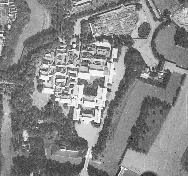
日本語: 画像上側が北であり、東側の表宮殿と西側の奥宮殿が一体となった造りである。
表宮殿南端から北に向かって順に御車寄・正殿・豊明殿と並び、豊明殿のすぐ西には千種の間が接続する。正殿と豊明殿の間には中庭がある。 宮殿の北側には建て替え工事中の宮内省が隣接し、その敷地西端にはまだ取り壊されていない旧省舎の一部が確認できる。 南端に見える橋は二重橋、東にあるのは坂下門である。 写真の撮影日は不明だが、『大林組70年略史』[1]より現宮内省舎への建て替え工事の受託は1934年9月、竣工は1936年10月とあることから、写真はこの間に撮影されたものと推定される。 [1]大林組(1961)「大林組70年略史」〈https://www.obayashi.co.jp/chronicle/70yrs/t7.html〉(2023年9月7日閲覧) |
| Date | 1935年ごろ |
| Source |
|
| Author |
日本語: 国土地理院、寄辺ナキが加工。
English: Geospatial Information Authority of Japan, modified by 寄辺ナキ |
| Camera location | | View this and other nearby images on: OpenStreetMap |
|---|
Licensing

|
The copyright holder of this file, the Ministry of Land, Infrastructure, Transport and Tourism of Japan, allows anyone to use it for any purpose, provided that the copyright holder is properly attributed. Redistribution, derivative work, commercial use, and all other use is permitted. |
Attribution:
Copyright © National Land Image Information (Color Aerial Photographs), Ministry of Land, Infrastructure, Transport and Tourism
|
 |
This image is copyrighted by the Ministry of Land, Infrastructure, Transport and Tourism of Japan. For terms of use, see the stipulation to use of National Land Information (in Japanese) and message from MLIT (in Japanese and English). When you display this image on an article, include the following phrase in the description: "Made based on National Land Image Information (Color Aerial Photographs), Ministry of Land, Infrastructure, Transport and Tourism".
|
File history
Click on a date/time to view the file as it appeared at that time.
| Date/Time | Thumbnail | Dimensions | User | Comment | |
|---|---|---|---|---|---|
| current | 13:27, 7 September 2023 | | 1,241 × 1,163 (337 KB) | <bdi>寄辺ナキ</bdi> | Uploaded a work by {{ja|国土地理院、寄辺ナキが加工。}} {{en|Geospatial Information Authority of Japan, modified by 寄辺ナキ}} from *国土交通省「国土画像情報(モノクロ空中写真)」(配布元:国土地理院地図・空中写真閲覧サービス) **[https://mapps.gsi.go.jp/maplibSearch.do?specificationId=1158791 M23ロ-C2-37] with UploadWizard |
File usage
The following pages on the English Wikipedia use this file (pages on other projects are not listed):