

Size of this preview: 800 × 441 pixels. Other resolutions: 320 × 177 pixels | 640 × 353 pixels | 1,024 × 565 pixels | 1,280 × 706 pixels | 2,560 × 1,412 pixels | 12,000 × 6,621 pixels.
Original file (12,000 × 6,621 pixels, file size: 57.14 MB, MIME type: image/jpeg)
| This is a file from the Wikimedia Commons. Information from its description page there is shown below. Commons is a freely licensed media file repository. You can help. |
Summary
| Warning | The original file is very high-resolution. It might not load properly or could cause your browser to freeze when opened at full size. |
|---|
| Description |
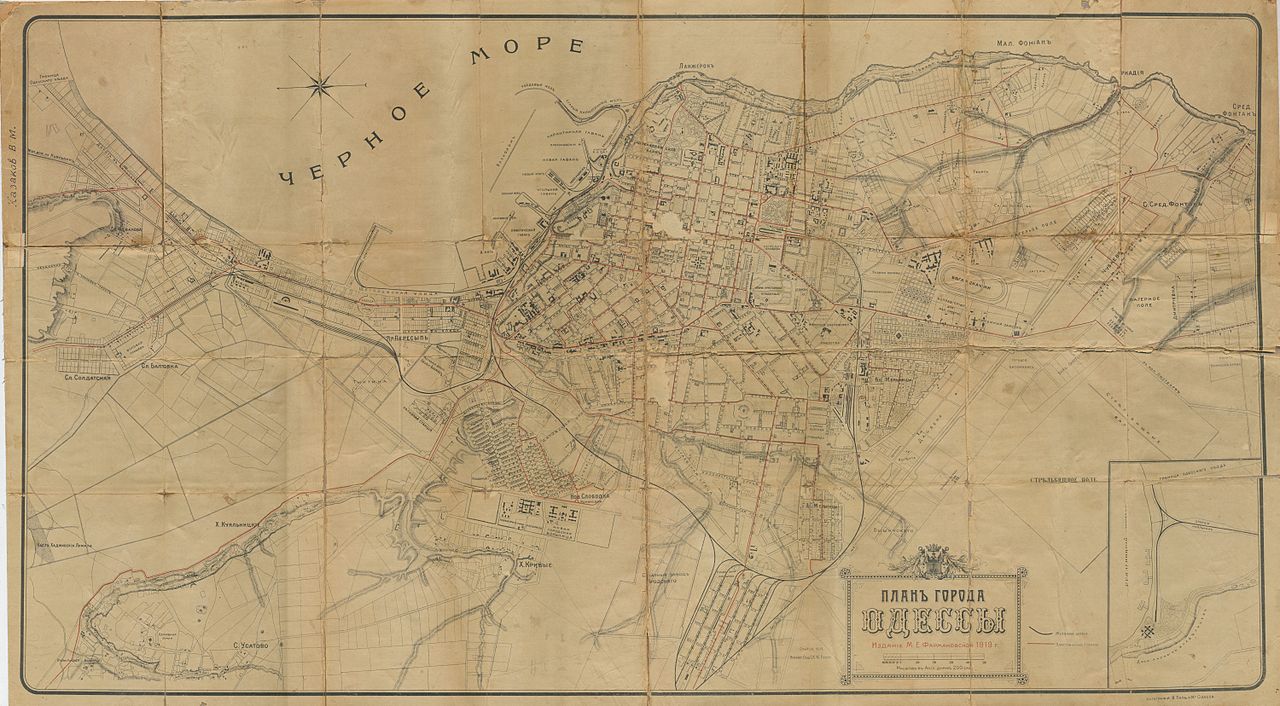
Русский: "Планъ города Одессы.
Изданie М. Е. Фармаковской 1919 г." В левом верхнем углу подпись владельца - "Казаков В. М.", - приобретшего его в 1949 году на Староконном рынке за 50 коп. Из-за ветхости в 70-е годы был подреставрирован и наклеен на переплётную ткань.English: Map of Odessa Français : Plan d'Odessa en 1919 : le nord est à gauche. |
|||||||||
| Date | ||||||||||
| Source |
Русский: Документ принадлежит потомкам Веселаго, Турбаевских и Казаковых. Отсканирован Алексеем Турбаевским (cheloVechek / talk) с оригинала из собственного архива.
English: The document is owned by the descendants of Veselago, Tourbaevsky & Kazakov. Scanned by Alexey Tourbaevsky (cheloVechek / talk) from original in own archive.
Français : La photo est détenue par les descendants de Veselago, Tourbaevsky & Kazakov. Numériser par Alexey Tourbaevsky (cheloVechek / talk) de l'original en propre archive. |
|||||||||
| Creator |
Русский: Не указывается English: Not credited |
|||||||||
| Geotemporal data | ||||||||||
| Date depicted | ||||||||||
| Map type | city_map | |||||||||
| Heading |
 |
|||||||||
| Bounding box |
|
|||||||||
| Georeferencing | ||||||||||
Licensing
I, the copyright holder of this work, hereby publish it under the following license:
This file is licensed under the Creative Commons Attribution-Share Alike 4.0 International license.
- You are free:
- to share – to copy, distribute and transmit the work
- to remix – to adapt the work
- Under the following conditions:
- attribution – You must give appropriate credit, provide a link to the license, and indicate if changes were made. You may do so in any reasonable manner, but not in any way that suggests the licensor endorses you or your use.
- share alike – If you remix, transform, or build upon the material, you must distribute your contributions under the same or compatible license as the original.
File history
Click on a date/time to view the file as it appeared at that time.
| Date/Time | Thumbnail | Dimensions | User | Comment | |
|---|---|---|---|---|---|
| current | 04:27, 5 August 2014 | | 12,000 × 6,621 (57.14 MB) | CheloVechek | Уменьшенный размер III |
| 11:37, 2 August 2014 |  | 21,952 × 12,112 (24.12 MB) | CheloVechek | Уменьшенный размер II | |
| 09:20, 2 August 2014 |  | 21,952 × 12,112 (43.12 MB) | CheloVechek | Уменьшенный размер | |
| 04:22, 2 August 2014 |  | 21,952 × 12,112 (56.99 MB) | CheloVechek | Повтор загрузки | |
| 00:25, 2 August 2014 |  | 21,952 × 12,112 (56.99 MB) | CheloVechek | User created page with UploadWizard |
File usage
The following pages on the English Wikipedia use this file (pages on other projects are not listed):
Global file usage
The following other wikis use this file:
- Usage on ba.wikipedia.org
- Usage on ceb.wikipedia.org
- Usage on fr.wikipedia.org
- Usage on ru.wikipedia.org
- Usage on uk.wikipedia.org
- Usage on www.wikidata.org