

Size of this preview: 660 × 600 pixels. Other resolutions: 264 × 240 pixels | 528 × 480 pixels | 846 × 768 pixels | 1,127 × 1,024 pixels | 1,932 × 1,755 pixels.
Original file (1,932 × 1,755 pixels, file size: 322 KB, MIME type: image/png)
| This is a file from the Wikimedia Commons. Information from its description page there is shown below. Commons is a freely licensed media file repository. You can help. |
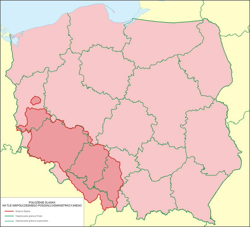
| Description | Położenie Śląska na tle współczesnego podziału administracyjnego |
| Date | |
| Source | własna praca na podstawie: Kazimierz Orzechowski, Historia Ustroju Śląska 1202-1740, Wrocław 2005 r., s. 147, ISBN 83-229-2654-5 |
| Author | Poznaniak |
| Permission (Reusing this file) |
I, the copyright holder of this work, hereby publish it under the following license: This file is licensed under the Creative Commons Attribution-Share Alike 3.0 Unported license.
|
Mapa nie odzwierciedla historycznej Dzielnicy Śląskiej Królestwa Polskeigo, pomijając ziemie śląskie, które pozostały w I Rzeczypospolitej, tj. Księstwo Oświęcimsko-Zatorskie i Księswto Żywieckie (późniejszy Powiat Śląski Królestwa Polskiego) oraz Księstwo Siewierskie.
File history
Click on a date/time to view the file as it appeared at that time.
| Date/Time | Thumbnail | Dimensions | User | Comment | |
|---|---|---|---|---|---|
| current | 11:29, 9 July 2023 | | 1,932 × 1,755 (322 KB) | Poznaniak | Reverted to version as of 11:03, 17 November 2019 (UTC) brak źródeł |
| 19:40, 28 May 2023 |  | 1,932 × 1,755 (359 KB) | Konrad Wiadomości Wąż | Dokładniejsze granice | |
| 11:03, 17 November 2019 |  | 1,932 × 1,755 (322 KB) | Poznaniak | Reverted to version as of 16:31, 31 December 2013 (UTC) | |
| 16:16, 8 November 2019 |  | 1,932 × 1,755 (306 KB) | Claude Zygiel | Differentiate Silesia '''in''' Poland and '''out''' of Poland today. | |
| 16:31, 31 December 2013 |  | 1,932 × 1,755 (322 KB) | Poznaniak | {{Information |Description=Położenie Śląska na tle współczesnego podziału administracyjnego |Source=własna praca na podstawie: Kazimierz Orzechowski, Historia Ustroju Śląska 1202-1740, Wrocław 2005 r., s. 147, ISBN 83-229-2654-5 |Date=31 gru... |
File usage
The following pages on the English Wikipedia use this file (pages on other projects are not listed):
Global file usage
The following other wikis use this file:
- Usage on ast.wikipedia.org
- Usage on bg.wikipedia.org
- Usage on cs.wikipedia.org
- Usage on dsb.wikipedia.org
- Usage on es.wikipedia.org
- Usage on fr.wikipedia.org
- Usage on gn.wikipedia.org
- Usage on he.wikipedia.org
- Usage on it.wikipedia.org
- Usage on it.wiktionary.org
- Usage on ja.wikipedia.org
- Usage on ko.wikipedia.org
- Usage on lv.wikipedia.org
- Usage on pl.wikipedia.org
- Usage on pl.wiktionary.org
- Usage on pt.wikipedia.org
- Usage on szl.wikipedia.org
- Usage on ta.wikipedia.org
- Usage on tr.wikipedia.org
- Usage on uk.wikipedia.org
- Usage on vi.wikipedia.org
- Usage on zh.wikipedia.org