
No higher resolution available.
'Resolution'_in_Belfast_-_geograph.org.uk_-_636807.jpg (640 × 460 pixels, file size: 56 KB, MIME type: image/jpeg)
| This is a file from the Wikimedia Commons. Information from its description page there is shown below. Commons is a freely licensed media file repository. You can help. |
Summary
| Description |
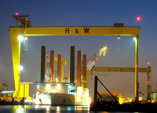
'Resolution' in Belfast. The highly unusual ship 'Resolution' in the building dock at Harland and Wolff in Belfast beneath the gantry cranes 'Samson' and 'Goliath' 599214
The ship is used in the construction of offshore windfarms and was in Belfast to collect turbine foundations that had been manufactured by Harland and Wolff for an offshore windfarm in the Solway Firth (see http://news.bbc.co.uk/1/hi/scotland/south_of_scotland/7151034.stm ). Its unusual shape comes from the six 130m legs which, once on site, jacks the vessel out of the water and provides a stable working platform to construct windfarms at sea. See http://www.ship-technology.com/projects/mayflower/ for some technical info on the Resolution. |
| Date | |
| Source | From geograph.org.uk |
| Author | Ross |
_-_geograph.org.uk_-_599214.jpg)
| Camera location | | View this and other nearby images on: OpenStreetMap |
|---|
_heading:202.00&language=en)
| Object location | | View this and other nearby images on: OpenStreetMap |
|---|
_heading:202.00&language=en)
Licensing

|
This image was taken from the Geograph project collection. See this photograph's page on the Geograph website for the photographer's contact details. The copyright on this image is owned by Ross and is licensed for reuse under the Creative Commons Attribution-ShareAlike 2.0 license.
|
This file is licensed under the Creative Commons Attribution-Share Alike 2.0 Generic license.
Attribution: Ross
- You are free:
- to share – to copy, distribute and transmit the work
- to remix – to adapt the work
- Under the following conditions:
- attribution – You must give appropriate credit, provide a link to the license, and indicate if changes were made. You may do so in any reasonable manner, but not in any way that suggests the licensor endorses you or your use.
- share alike – If you remix, transform, or build upon the material, you must distribute your contributions under the same or compatible license as the original.
File history
Click on a date/time to view the file as it appeared at that time.
| Date/Time | Thumbnail | Dimensions | User | Comment | |
|---|---|---|---|---|---|
| current | 08:27, 7 February 2011 | | 640 × 460 (56 KB) | GeographBot | == {{int:filedesc}} == {{Information |description={{en|1='Resolution' in Belfast The highly unusual ship 'Resolution' in the building dock at Harland and Wolff in Belfast beneath the gantry cranes 'Samson' and 'Goliath' 599214 The ship is used in the |
File usage
The following pages on the English Wikipedia use this file (pages on other projects are not listed):
Global file usage
The following other wikis use this file:
- Usage on es.wikipedia.org
- Usage on et.wikipedia.org
- Usage on nl.wikipedia.org
- Usage on pl.wikipedia.org
- Usage on sv.wikipedia.org
- Usage on zh.wikipedia.org