
| Far North Line | ||||||||||||||||||||||||||||||||||||||||||||||||||||||||||||||||||||||||||||||||||||||||||||||||||||||||||||||||||||||||||||||||||||||||||||||||||||||||||||||||||||||||||||||||||||||||||||||||||||||||||||||||||||||||||||||||||||||||||||||||||||||||||||||||||||||||||||||||||||||||||||||||||||||||||||||||||||||||||||||||||||||||||||||||||||||||||||||||||||||||||||||||||||||||||||||||||||||||||||||||||||||||||||||||||||||||
|---|---|---|---|---|---|---|---|---|---|---|---|---|---|---|---|---|---|---|---|---|---|---|---|---|---|---|---|---|---|---|---|---|---|---|---|---|---|---|---|---|---|---|---|---|---|---|---|---|---|---|---|---|---|---|---|---|---|---|---|---|---|---|---|---|---|---|---|---|---|---|---|---|---|---|---|---|---|---|---|---|---|---|---|---|---|---|---|---|---|---|---|---|---|---|---|---|---|---|---|---|---|---|---|---|---|---|---|---|---|---|---|---|---|---|---|---|---|---|---|---|---|---|---|---|---|---|---|---|---|---|---|---|---|---|---|---|---|---|---|---|---|---|---|---|---|---|---|---|---|---|---|---|---|---|---|---|---|---|---|---|---|---|---|---|---|---|---|---|---|---|---|---|---|---|---|---|---|---|---|---|---|---|---|---|---|---|---|---|---|---|---|---|---|---|---|---|---|---|---|---|---|---|---|---|---|---|---|---|---|---|---|---|---|---|---|---|---|---|---|---|---|---|---|---|---|---|---|---|---|---|---|---|---|---|---|---|---|---|---|---|---|---|---|---|---|---|---|---|---|---|---|---|---|---|---|---|---|---|---|---|---|---|---|---|---|---|---|---|---|---|---|---|---|---|---|---|---|---|---|---|---|---|---|---|---|---|---|---|---|---|---|---|---|---|---|---|---|---|---|---|---|---|---|---|---|---|---|---|---|---|---|---|---|---|---|---|---|---|---|---|---|---|---|---|---|---|---|---|---|---|---|---|---|---|---|---|---|---|---|---|---|---|---|---|---|---|---|---|---|---|---|---|---|---|---|---|---|---|---|---|---|---|---|---|---|---|---|---|---|---|---|---|---|---|---|---|---|---|---|---|---|---|---|---|---|---|---|---|---|---|---|---|---|---|---|---|---|---|---|---|---|---|---|---|---|---|---|---|---|---|---|---|---|---|---|---|---|---|---|---|---|---|---|---|
 | ||||||||||||||||||||||||||||||||||||||||||||||||||||||||||||||||||||||||||||||||||||||||||||||||||||||||||||||||||||||||||||||||||||||||||||||||||||||||||||||||||||||||||||||||||||||||||||||||||||||||||||||||||||||||||||||||||||||||||||||||||||||||||||||||||||||||||||||||||||||||||||||||||||||||||||||||||||||||||||||||||||||||||||||||||||||||||||||||||||||||||||||||||||||||||||||||||||||||||||||||||||||||||||||||||||||||
| Overview | ||||||||||||||||||||||||||||||||||||||||||||||||||||||||||||||||||||||||||||||||||||||||||||||||||||||||||||||||||||||||||||||||||||||||||||||||||||||||||||||||||||||||||||||||||||||||||||||||||||||||||||||||||||||||||||||||||||||||||||||||||||||||||||||||||||||||||||||||||||||||||||||||||||||||||||||||||||||||||||||||||||||||||||||||||||||||||||||||||||||||||||||||||||||||||||||||||||||||||||||||||||||||||||||||||||||||
| Status | Operational | |||||||||||||||||||||||||||||||||||||||||||||||||||||||||||||||||||||||||||||||||||||||||||||||||||||||||||||||||||||||||||||||||||||||||||||||||||||||||||||||||||||||||||||||||||||||||||||||||||||||||||||||||||||||||||||||||||||||||||||||||||||||||||||||||||||||||||||||||||||||||||||||||||||||||||||||||||||||||||||||||||||||||||||||||||||||||||||||||||||||||||||||||||||||||||||||||||||||||||||||||||||||||||||||||||||||
| Owner | Network Rail | |||||||||||||||||||||||||||||||||||||||||||||||||||||||||||||||||||||||||||||||||||||||||||||||||||||||||||||||||||||||||||||||||||||||||||||||||||||||||||||||||||||||||||||||||||||||||||||||||||||||||||||||||||||||||||||||||||||||||||||||||||||||||||||||||||||||||||||||||||||||||||||||||||||||||||||||||||||||||||||||||||||||||||||||||||||||||||||||||||||||||||||||||||||||||||||||||||||||||||||||||||||||||||||||||||||||
| Locale | Highland Scotland | |||||||||||||||||||||||||||||||||||||||||||||||||||||||||||||||||||||||||||||||||||||||||||||||||||||||||||||||||||||||||||||||||||||||||||||||||||||||||||||||||||||||||||||||||||||||||||||||||||||||||||||||||||||||||||||||||||||||||||||||||||||||||||||||||||||||||||||||||||||||||||||||||||||||||||||||||||||||||||||||||||||||||||||||||||||||||||||||||||||||||||||||||||||||||||||||||||||||||||||||||||||||||||||||||||||||
| Termini | ||||||||||||||||||||||||||||||||||||||||||||||||||||||||||||||||||||||||||||||||||||||||||||||||||||||||||||||||||||||||||||||||||||||||||||||||||||||||||||||||||||||||||||||||||||||||||||||||||||||||||||||||||||||||||||||||||||||||||||||||||||||||||||||||||||||||||||||||||||||||||||||||||||||||||||||||||||||||||||||||||||||||||||||||||||||||||||||||||||||||||||||||||||||||||||||||||||||||||||||||||||||||||||||||||||||||
| Stations | 26 | |||||||||||||||||||||||||||||||||||||||||||||||||||||||||||||||||||||||||||||||||||||||||||||||||||||||||||||||||||||||||||||||||||||||||||||||||||||||||||||||||||||||||||||||||||||||||||||||||||||||||||||||||||||||||||||||||||||||||||||||||||||||||||||||||||||||||||||||||||||||||||||||||||||||||||||||||||||||||||||||||||||||||||||||||||||||||||||||||||||||||||||||||||||||||||||||||||||||||||||||||||||||||||||||||||||||
| Service | ||||||||||||||||||||||||||||||||||||||||||||||||||||||||||||||||||||||||||||||||||||||||||||||||||||||||||||||||||||||||||||||||||||||||||||||||||||||||||||||||||||||||||||||||||||||||||||||||||||||||||||||||||||||||||||||||||||||||||||||||||||||||||||||||||||||||||||||||||||||||||||||||||||||||||||||||||||||||||||||||||||||||||||||||||||||||||||||||||||||||||||||||||||||||||||||||||||||||||||||||||||||||||||||||||||||||
| System | National Rail | |||||||||||||||||||||||||||||||||||||||||||||||||||||||||||||||||||||||||||||||||||||||||||||||||||||||||||||||||||||||||||||||||||||||||||||||||||||||||||||||||||||||||||||||||||||||||||||||||||||||||||||||||||||||||||||||||||||||||||||||||||||||||||||||||||||||||||||||||||||||||||||||||||||||||||||||||||||||||||||||||||||||||||||||||||||||||||||||||||||||||||||||||||||||||||||||||||||||||||||||||||||||||||||||||||||||
| Operator(s) | ScotRail | |||||||||||||||||||||||||||||||||||||||||||||||||||||||||||||||||||||||||||||||||||||||||||||||||||||||||||||||||||||||||||||||||||||||||||||||||||||||||||||||||||||||||||||||||||||||||||||||||||||||||||||||||||||||||||||||||||||||||||||||||||||||||||||||||||||||||||||||||||||||||||||||||||||||||||||||||||||||||||||||||||||||||||||||||||||||||||||||||||||||||||||||||||||||||||||||||||||||||||||||||||||||||||||||||||||||
| Rolling stock | Class 158 "Express Sprinter" | |||||||||||||||||||||||||||||||||||||||||||||||||||||||||||||||||||||||||||||||||||||||||||||||||||||||||||||||||||||||||||||||||||||||||||||||||||||||||||||||||||||||||||||||||||||||||||||||||||||||||||||||||||||||||||||||||||||||||||||||||||||||||||||||||||||||||||||||||||||||||||||||||||||||||||||||||||||||||||||||||||||||||||||||||||||||||||||||||||||||||||||||||||||||||||||||||||||||||||||||||||||||||||||||||||||||
| History | ||||||||||||||||||||||||||||||||||||||||||||||||||||||||||||||||||||||||||||||||||||||||||||||||||||||||||||||||||||||||||||||||||||||||||||||||||||||||||||||||||||||||||||||||||||||||||||||||||||||||||||||||||||||||||||||||||||||||||||||||||||||||||||||||||||||||||||||||||||||||||||||||||||||||||||||||||||||||||||||||||||||||||||||||||||||||||||||||||||||||||||||||||||||||||||||||||||||||||||||||||||||||||||||||||||||||
| Opened | 1862–1874 | |||||||||||||||||||||||||||||||||||||||||||||||||||||||||||||||||||||||||||||||||||||||||||||||||||||||||||||||||||||||||||||||||||||||||||||||||||||||||||||||||||||||||||||||||||||||||||||||||||||||||||||||||||||||||||||||||||||||||||||||||||||||||||||||||||||||||||||||||||||||||||||||||||||||||||||||||||||||||||||||||||||||||||||||||||||||||||||||||||||||||||||||||||||||||||||||||||||||||||||||||||||||||||||||||||||||
| Technical | ||||||||||||||||||||||||||||||||||||||||||||||||||||||||||||||||||||||||||||||||||||||||||||||||||||||||||||||||||||||||||||||||||||||||||||||||||||||||||||||||||||||||||||||||||||||||||||||||||||||||||||||||||||||||||||||||||||||||||||||||||||||||||||||||||||||||||||||||||||||||||||||||||||||||||||||||||||||||||||||||||||||||||||||||||||||||||||||||||||||||||||||||||||||||||||||||||||||||||||||||||||||||||||||||||||||||
| Line length | Inverness to Wick: 161 miles 33 chains (259.8 km) Georgemas Junction to Thurso: 6 miles 50 chains (10.7 km) Total: 168 miles 03 chains (270.4 km) | |||||||||||||||||||||||||||||||||||||||||||||||||||||||||||||||||||||||||||||||||||||||||||||||||||||||||||||||||||||||||||||||||||||||||||||||||||||||||||||||||||||||||||||||||||||||||||||||||||||||||||||||||||||||||||||||||||||||||||||||||||||||||||||||||||||||||||||||||||||||||||||||||||||||||||||||||||||||||||||||||||||||||||||||||||||||||||||||||||||||||||||||||||||||||||||||||||||||||||||||||||||||||||||||||||||||
| Number of tracks | Single-track with passing loops | |||||||||||||||||||||||||||||||||||||||||||||||||||||||||||||||||||||||||||||||||||||||||||||||||||||||||||||||||||||||||||||||||||||||||||||||||||||||||||||||||||||||||||||||||||||||||||||||||||||||||||||||||||||||||||||||||||||||||||||||||||||||||||||||||||||||||||||||||||||||||||||||||||||||||||||||||||||||||||||||||||||||||||||||||||||||||||||||||||||||||||||||||||||||||||||||||||||||||||||||||||||||||||||||||||||||
| Character | Rural | |||||||||||||||||||||||||||||||||||||||||||||||||||||||||||||||||||||||||||||||||||||||||||||||||||||||||||||||||||||||||||||||||||||||||||||||||||||||||||||||||||||||||||||||||||||||||||||||||||||||||||||||||||||||||||||||||||||||||||||||||||||||||||||||||||||||||||||||||||||||||||||||||||||||||||||||||||||||||||||||||||||||||||||||||||||||||||||||||||||||||||||||||||||||||||||||||||||||||||||||||||||||||||||||||||||||
| Track gauge | 4 ft 8+1⁄2 in (1,435 mm) standard gauge | |||||||||||||||||||||||||||||||||||||||||||||||||||||||||||||||||||||||||||||||||||||||||||||||||||||||||||||||||||||||||||||||||||||||||||||||||||||||||||||||||||||||||||||||||||||||||||||||||||||||||||||||||||||||||||||||||||||||||||||||||||||||||||||||||||||||||||||||||||||||||||||||||||||||||||||||||||||||||||||||||||||||||||||||||||||||||||||||||||||||||||||||||||||||||||||||||||||||||||||||||||||||||||||||||||||||
| Electrification | None | |||||||||||||||||||||||||||||||||||||||||||||||||||||||||||||||||||||||||||||||||||||||||||||||||||||||||||||||||||||||||||||||||||||||||||||||||||||||||||||||||||||||||||||||||||||||||||||||||||||||||||||||||||||||||||||||||||||||||||||||||||||||||||||||||||||||||||||||||||||||||||||||||||||||||||||||||||||||||||||||||||||||||||||||||||||||||||||||||||||||||||||||||||||||||||||||||||||||||||||||||||||||||||||||||||||||
| ||||||||||||||||||||||||||||||||||||||||||||||||||||||||||||||||||||||||||||||||||||||||||||||||||||||||||||||||||||||||||||||||||||||||||||||||||||||||||||||||||||||||||||||||||||||||||||||||||||||||||||||||||||||||||||||||||||||||||||||||||||||||||||||||||||||||||||||||||||||||||||||||||||||||||||||||||||||||||||||||||||||||||||||||||||||||||||||||||||||||||||||||||||||||||||||||||||||||||||||||||||||||||||||||||||||||
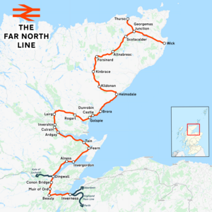
The Far North Line is a rural railway line entirely within the Highland area of Scotland, extending from Inverness to Thurso and Wick. As the name suggests, it is the northernmost railway in the United Kingdom. The line is entirely single-track, with only passing loops at some intermediate stations allowing trains to pass each other. In common with other railway lines in the Highlands and northern Lowlands, it is not electrified and all trains are diesel-powered.
YouTube Encyclopedic
-
1/1Views:34 371
-
The Far North Driver's eye view preview
Transcription
Route
The line links the city of Inverness, the largest city in the Scottish Highlands, with the towns of Wick and Thurso at the northeastern tip of Britain.
Like the A9 trunk road north of Inverness, the Far North Line broadly follows the east-facing coastline of the Moray Firth, with all three termini located on the coast. As such, the railway links many of the same places as the road.
Many more places were served by both the railway and the road before three new road bridges were built: across the Beauly Firth (between Inverness and the Black Isle), the Cromarty Firth and the Dornoch Firth. As a result, at some locations the railway is now a long way inland from the modern route of the A9.
The railway also loops a long way inland between Tain and Golspie, running via Lairg, which has never been on the A9; it was envisaged at the time of construction that this diversion would open the centre of Sutherland to trade. It also takes a large inland detour north of Helmsdale, running via the Flow Country, which the A9 also never passed through; this diversion was dictated by the unfavourable terrain of the Caithness coastline.
Inverness–Tain: through Ross-shire

The railway line begins at Inverness station,[A] where passenger connections are available for the Highland Main Line (to Perth, Glasgow, Edinburgh and London) and the Aberdeen–Inverness line (to Inverness Airport, Elgin and Aberdeen), as well as for bus services to destinations throughout the Scottish Highlands. While the A9 leaves Inverness by crossing the Beauly Firth on the Kessock Bridge, the Far North Line instead heads west and runs alongside the Firth.

The single track crosses both the River Ness and the Caledonian Canal before it leaves Inverness and parallels the A862 road[a] towards the village of Beauly. After 10 miles (16 km), the line crosses the River Beauly and then takes a sharp, almost 180° right turn (from a west-southwest heading to north-northeast); Beauly station[B] is located halfway along this curve. Closed in 1960, the station reopened in 2002[2] and its single operational platform has the distinction of being the shortest on the National Rail network, at just 15.06 metres (49 ft 5 in).[3]
The line then carries on north, crossing the historic county boundary from Inverness-shire into Ross and Cromarty just before reaching Muir of Ord station,[C] which has two platforms and is the site of the first passing loop on the line.[1] The line continues to parallel the A862 as it passes through Conon Bridge station,[D] which reopened in 2013 in a similar style to Beauly[4] and whose platform is just 2 centimetres (0.8 in) longer than that at Beauly. Shortly afterwards, the line crosses the River Conon and passes through the village of Maryburgh before reaching Dingwall station[E] – the busiest station on the line aside from Inverness, with just over 80 thousand passengers recorded in the 2019–20 financial year.[5]
At Dingwall Junction[F] just north of the station, the Kyle of Lochalsh line diverges to the west.[6] The Far North Line, meanwhile, rejoins the coast and continues northeast along the shoreline of the Cromarty Firth; the railway meets the A9 again shortly after, at the north end of the Cromarty Bridge.

The next station on the line is Alness,[G] which closed in 1960 but reopened 13 years later. After Alness the line turns gently eastwards to reach Invergordon station[H] before turning northeast again. The line continues in this direction for nearly 10 miles (16 km) without another station until Fearn.[I] Located approximately 1.2 miles (1.9 km) west of Hill of Fearn, the primary source of traffic at the station, it is also the nearest railway stop to the Seaboard Villages. The railway then takes a sharp turn to run northwest for approximately 3 miles (5 km) until it reaches Tain station[J] on the south side of the Dornoch Firth.
Tain–Helmsdale: Lairg loop and the Sutherland coast
A short distance west of Tain, the Far North Line and the A9 part ways again – while the road crosses the Dornoch Firth by means of a 900-metre (3,000 ft) bridge,[b] the railway line instead follows the coast of the Firth. In fact, the railway does not return to an open coastline for another 40 route miles (64 km) until Golspie, even though the distance between Tain and Golspie as the crow flies is only 11.1 miles (17.9 km). There have been many unsuccessful proposals to build a new, shorter railway line between the two villages via Dornoch,[c] which led to the existing route via Lairg being sometimes unofficially called the "Lairg loop".[7]
Soon after the A9 splits away, the line crosses the lieutenancy area boundary from Ross and Cromarty into Sutherland. The track follows the route of the A836 until the next station on the line, Ardgay,[K] at the end of the Dornoch Firth. The station is in the village of Ardgay and also serves the slightly larger village of Bonar Bridge on the opposite side of the Kyle of Sutherland.

From Ardgay, the line runs northwards alongside the Kyle, and after just over 3 miles (5 km) it reaches the first two request stops en route – Culrain[L] and Invershin,[M] which lie on either side of the Invershin Viaduct over the Kyle. At just 34 chains (680 m), the distance between these two stations is among the shortest in all of Britain.[8][d] There is no direct road connection between the two sides of the Kyle at this location, and a public footpath was only built alongside the viaduct in 2000; prior to this, the railway was the only way to travel between the two stations without taking a 7-mile-long (11 km) detour via Bonar Bridge. The Kyle once also marked the boundary between the historic counties of Ross and Cromarty and Sutherland; however, the modern boundary between the respective lieutenancy areas lies several miles to the south, putting both stations in modern-day Sutherland.

The track then continues northwards along the River Shin for another 5.5 miles (8.9 km) until it reaches Lairg station,[N] located about 1.6 miles (2.6 km) south of the village itself. This is the furthest point away from the coast on the Lairg loop; beyond the station the line curves sharply eastwards and heads back towards the Moray Firth along Strath Fleet, now paralleling the A839 road. The line then passes through another request stop, Rogart,[O] which actually lies in the small hamlet of Pittentrail and about 1.5 miles (2.4 km) south of Rogart itself; the station briefly closed in 1960, only to be reopened less than 9 months later. Immediately east of the station there is an open level crossing – one of only two on the line.[1] Four miles (6.4 km) after Rogart, the railway meets the A9 again, as it passes by Mound Alderwoods and Loch Fleet. This was once the site of The Mound station and a junction with the Dornoch Light Railway to Dornoch;[10] both the station and the branch closed in 1960.[11] The railway then turns northeast and returns to the coast at Golspie, with the station[P] located at the western end of the village.

Just east of Golspie, the line meets Dunrobin Castle station,[Q] which was built as a private, single-platform halt for the Duke of Sutherland to serve Dunrobin Castle a short distance south of the track.[12] The station closed in 1965 but reopened in 1985;[12] today, the station is a public request stop, although it is only open during the summer months (one of only two such stations on the National Rail network, alongside Falls of Cruachan elsewhere in Scotland),[13] corresponding to the castle's annual opening times.[14] The station is also notable for its lack of lighting; as such, no trains are scheduled to call at the platform before 9 am or after about 6 pm.[13]
The line continues along the coast for another 15 miles (24 km), occasionally coming just metres away from the shoreline, passing through Brora station[R] before reaching the village of Helmsdale, located at the mouth of the river of the same name. Helmsdale station[S] lies on the other side of the river from most of the village.
Helmsdale–Wick/Thurso: Strath of Kildonan and Caithness


Beyond Helmsdale, the railway is forced to divert away from the Moray Firth coast and from the A9 once again, avoiding the unfavourable terrain of the Ord of Caithness. Instead, the line takes a sharp turn northwest and heads inland towards the Flow Country – the largest expanse of blanket bog in Europe. This is by far the most remote section of the entire line: the majority of the intermediate stations along this stretch are request stops,[13] and each station only serves a handful of isolated houses.
Initially, the single track follows the course of the Strath of Kildonan together with the A897. Kildonan station,[T] one of the least-used stations on the line,[5] lies approximately halfway along the Strath; the second open level crossing on the line is just to the southeast of the station.[1] The far end of the Strath, close to the point where the A897 meets the B871 road, marks the location of Kinbrace station.[U]
Beyond Kinbrace, in stark contrast to the rest of the line (and most of the Scottish Highlands), the topography of the surrounding area becomes flat and low-lying, and will remain so until the railway's two northern termini. The line carries on northwards alongside the A897 for seven and a half more miles (12.1 km) until it reaches Forsinard station[V] which, despite its isolation, is not a request stop.[13] With two platforms, this station is the last place on the line where passenger trains running in opposite directions can pass each other.[1] The station serves the Forsinard Flows National Nature Reserve, among other nearby parts of the Flow Country; an RSPB visitor centre is adjacent to the station platforms. At Forsinard, the line crosses the A897, turns east-northeast, and does not meet another public road for over 17 miles (27 km). Soon, the line leaves the county of Sutherland and enters Caithness.
As the track passes through Caithness countryside, it eventually reaches Altnabreac station.[W] This single-platform halt is often listed as one of Britain's most geographically isolated railway stations, being about 11 miles (18 km) from the nearest village and 6.8 miles (11 km) from the nearest paved road.[8] There are, however, a handful of houses in the immediate vicinity of the station, accessed by a private dirt road, which is marked as a public cycle trail on Ordnance Survey maps.
The line then turns gently to the northeast, passing by several small lochs en route, before passing under the B870 road (the first public road close to the line since Forsinard). This is the site of Scotscalder station,[X] which is among the least-used stations on the line, typically averaging less than 1 passenger per day.[5] After another two and a half miles (4.0 km), the track passes south of Halkirk – the first unscattered village in over 44 route miles (71 km), although there is no longer a railway station serving it (the old station[Y] having closed in 1960 along with 19 others on the line). The line reaches its penultimate station, Georgemas Junction,[Z] at the point where the line crosses the A9 again. Adjoining the station on the south side is a freight terminal built in 2012 by Direct Rail Services; this was used by trains taking nuclear material from Dounreay to Sellafield.[15]


At Georgemas Junction, which is not a request stop, the lines to Thurso and Wick diverge; this is the northernmost railway junction in the United Kingdom.[1] The Wick-facing Thurso branch curves north immediately west of the station and runs alongside the River Thurso, paralleling the A9 until it reaches Thurso station[AA] – the northernmost railway station in Britain, by the northern coast of Scotland. Thurso is the nearest station to the ferry terminal at Scrabster, which has ferry services to and from the town of Stromness in the Orkney Islands. Meanwhile, the main line to Wick continues in an east-southeasterly direction, sandwiched between the A882 and B874 roads, and terminates at Wick station[AB] on the east coast. At 18 miles 35 chains (29.7 km), the distance between Georgemas Junction and Wick is the longest between any two adjacent stations on the line,[1] although three other stations existed along this stretch until 1960. Wick is the nearest station to Wick Airport as well as to the village of John o' Groats (approximately 17 miles (27 km) to the north) at the northeastern tip of mainland Britain, which is linked to the town by a bus service operated by Stagecoach Highlands.
Infrastructure
The full line between Inverness and Wick (excluding the Thurso branch) is 161 miles 33 chains (259.8 km) long; the Thurso branch has a length of 6 miles 50 chains (10.7 km).[1] The whole line is unelectrified.[1] Despite its considerable length and passing through the mostly mountainous Scottish Highlands, there are no tunnels on the line.[1]
The line is almost entirely single-track, but there are 10 double-track passing loops along the route, which allow trains to pass each other: these are at Muir of Ord, Dingwall, Invergordon, Tain, Ardgay, Lairg, Rogart, Brora, Helmsdale and Forsinard.[1] The loops at Rogart and Brora are not timetabled to be the passing place for any scheduled passenger services,[13] but they can be used as such during major disruption on the line.
The whole line north of the former Clunes station (about 7 miles (11 km) west of Inverness), together with the Kyle of Lochalsh line, are signalled using the Radio Electronic Token Block system, which is very cost-effective in both implementation and maintenance, but significantly limits the capacity of the lines.[16]
"Press & Ride" request stops
Between 2022 and 2023, the Far North Line became the first railway line in the United Kingdom to implement a new "Press & Ride" system for its request stops.[17]
Under the traditional system (still in use on the rest of the National Rail network), passengers wishing to board the train at a request stop had to flag the train by raising their arm; this meant that the driver needed to reduce the train's speed before a request stop (to look out for any potential passengers on the platform and be able to stop if necessary), even if the platform was empty. The new system, developed by Transport Scotland, envisaged the installation of an automatic kiosk (with a button for passengers to press) at each request stop. This alerts the driver about any waiting passengers in advance; if there is no requirement to stop, the train can maintain line speed through the station, thus improving reliability on the whole line.[18]
The first of these kiosks was installed at Scotscalder on 15 August 2022 on a trial basis.[19][17] Following the successful trial, the system was expanded on 20 December 2022 to cover five more request stops on the line, namely Culrain, Invershin, Rogart, Kildonan and Kinbrace.[20] A further kiosk was added at Dunrobin Castle in May 2023.[21] The last kiosk, at Altnabreac, was also expected to be in operation from spring 2023;[20] however, this has been delayed indefinitely, reportedly due to local homeowners blocking access to the station,[22] and as of December 2023[update] the kiosk is yet to be installed.
History

Pre-Nationalisation
The line was built in several stages:
- Inverness and Ross-shire Railway - Opened 11 June 1862 between Inverness and Ardgay
- Sutherland Railway - Opened 13 April 1868 between Ardgay and Golspie
- Duke of Sutherland's Railway - Opened 1 November 1870 between Golspie and Helmsdale
- Sutherland and Caithness Railway - Opened 28 July 1874 between Helmsdale and Wick / Thurso
Much of the work was done by the Inverness-based Highland Railway company or, when completed, taken over by that company. In 1923 the Highland Railway was grouped into the London, Midland and Scottish Railway, under the Railways Act 1921.
Like railway lines generally in Britain, the line was not a product of any strategic plan, but was an ad hoc development, facilitated by Private Acts of Parliament (which were themselves a significant expense for developers) and dependent on cooperation between companies and individuals, each with their own private vested interests. The line became strategically important during World War I and World War II as part of a supply route for Scapa Flow, Orkney.
That the line extends beyond Ardgay in the county of Ross and Cromarty is due, to a large extent, to the railway enthusiasm (some might say madness) of the 3rd Duke of Sutherland. The duke realised his dream of running his own private train to and from his own station at Dunrobin Castle.
The duke's enthusiasm took the line as far as Gartymore, a little south of Helmsdale, in the county of Sutherland, but this development was more of a financial liability than an asset: the long-term viability of the line then depended on a Caithness willingness, not least from the 17th Earl of Caithness, to link the line to the population centres of Wick and Thurso.
North of Helmsdale the line was built by the Sutherland and Caithness Railway. Turning inland, it reaches Forsinard in the Flow Country. The building of the line through the Flow Country – one of the most scarcely populated parts of Scotland – was to avoid the Berriedale Braes. North of Helmsdale as far as Lybster, it would have been impractical to build a railway without massive civil engineering projects. Thus coastal villages such as Latheron and Lybster are not served by the line.
In 1902, under the provisions of the Light Railways Act 1896, the standard gauge Wick and Lybster Railway was built along the east coast of Caithness, running south from Wick to Lybster.[e] This line was never profitable, and it closed in 1944.
Historic branch lines also served Dornoch and the Black Isle.
1989–90 flooding
On 7 February 1989, Ness Viaduct, just west of Inverness station, collapsed in unprecedented flooding. The remaining 270 miles (430 km) of network to Kyle of Lochalsh and The Far North line had to be operated from a temporary maintenance site at Muir of Ord. A new viaduct was opened in time for the 1990 summer season on 14 May 1990.[23]
Services
Current passenger services


All passenger trains are operated by ScotRail using Class 158 "Express Sprinter" diesel multiple units. The exact stopping pattern varies between each station, as not all trains run the full length of the Far North Line. All passenger services on the line start or terminate at Inverness.[13]
The service pattern is infrequent and very irregular, with intervals between consecutive trains at Inverness varying from just 15 minutes to as long as two-and-a-half hours.[13] As of 2022, on weekdays (including Saturdays), there are 14 trains per day (tpd) arriving at Inverness from the north, and 12 northbound departures:[13]
- 1 tpd each way shuttling to and from Dingwall only;
- 4 tpd to and from Kyle of Lochalsh (branching off the Far North Line at Dingwall);
- 1 tpd to and from Invergordon;
- 1 tpd to and from Tain;
- 2 tpd arriving from Ardgay with 1 tpd in the opposite direction;
- 1 tpd arriving from Lairg with no corresponding return service;
- 4 tpd running the full length to and from Wick via Thurso.
On Sundays the services are even less frequent, with just 1 tpd (2 in the summer) to/from Kyle of Lochalsh, 1 tpd to/from Invergordon, 3 tpd to/from Tain, and just a single train each way running all the way to/from Wick.
With the exception of some Wick services,[f] all trains are timetabled to stop at every intermediate station.[13] Dunrobin Castle station is only open during the summer months; no services call there in the winter.
The stations at Culrain, Invershin, Rogart, Dunrobin Castle, Kildonan, Kinbrace, Altnabreac and Scotscalder are designated as request stops: passengers wishing to board the train at these stations must press a button at a designated kiosk on the platform (except at Altnabreac, where passengers need to flag the train by raising their arm – see above), while those wishing to alight must inform the on-board guard to arrange for the train to stop. If there are no passengers wishing to get on or off the train, it will pass through without stopping.[13]
Since 2000, trains to and from Wick have run via Thurso. On arrival at Georgemas Junction from Inverness, trains reverse to serve Thurso, then reverse again from Thurso to run back to Georgemas Junction (stopping there for a second time) and continue on to Wick. This procedure is mirrored for Inverness-bound services.[13]
Services between Inverness and Wick typically have a journey time of about 4 hours 20 minutes end-to-end.[13]
Freight
Georgemas Junction has been used for freight handling and had a new railhead opened in 2012 for the transportation of nuclear flasks, but the terminal has not attracted any commercial operators since.[24] In 2020, a trial project funded by a £195,000 grant from the Scottish Government saw timber transported from Georgemas Junction to a processing facility near Inverness by Victa Railfreight.[25][26]
Previous services
1923–1948 (London Midland and Scottish Railway)
The London, Midland and Scottish Railway introduced two titled trains in 1936, the Orcadian and John O'Groat.[27]
1948–1997 (British Rail Scottish Region)

In 1963, the line was listed for closure on the Beeching Report; however, the Far North Line remained open due to pressure from protesters.[28]
Following the elimination of steam traction by the early 1960s, trains on the line were normally hauled by Inverness allocated Class 24 diesel locomotives (D5114-32), then subsequently by Class 26 diesel locomotives. In the 1980s these were replaced by more powerful Class 37 locomotives, still with Mark 1 rolling stock. These were replaced by Class 156s in the 1990s by British Rail. Three trains each way per day (Mon-Sat) was the standard service pattern at this time.
1997–2004 (ScotRail)

The service provided by ScotRail replicated that provided in the latter years of BR Scottish Region. ScotRail was owned by ScotRail (National Express) until 17 October 2004 when First ScotRail took over the franchise.
Until 2000, when the line was served by Class 156s, trains to Caithness were split at Georgemas Junction – one half of the train would continue to Thurso and the other to Wick. This practice ended when Class 158s were introduced on the line, adopting the current calling pattern.
2005–2015 (First ScotRail)
Along the full length of the line there were four services each way Monday to Saturday, including a service allowing a connection from the Orkney ferry, and one service each way on Sundays. In the Winter 2008/9 timetable the number of trains to and from Wick was increased to four each way on Mondays to Saturdays.
First ScotRail also operated a number of shorter distance services on the line from Inverness terminating at Dingwall and Ardgay, as an alternative commuter route to Inverness in addition to the A9 road.
Passenger volumes
| Entries and exits | 2002-03 | 2004-05 | 2005-06 | 2006-07 | 2007-08 | 2008-09 | 2009-10 | 2010-11 | 2011-12 | 2012-13 | 2013-14 | 2014-15 | 2015-16 | 2016-17 | 2017-18 | 2018-19 | 2019-20 | 2020-21 | 2021-22 | 2022-23 |
|---|---|---|---|---|---|---|---|---|---|---|---|---|---|---|---|---|---|---|---|---|
| Inverness | 721,358 | 822,928 | 873,011 | 915,840 | 975,570 | 1,043,712 | 1,070,924 | 1,127,718 | 1,180,160 | 1,213,382 | 1,282,445 | 1,303,662 | 1,306,556 | 1,259,496 | 1,238,770 | 1,243,338 | 1,214,648 | 231,894 | 753,228 | 974,808 |
| Beauly | 21,337 | 26,616 | 28,384 | 35,860 | 41,878 | 52,422 | 51,094 | 49,858 | 54,536 | 55,236 | 57,946 | 57,446 | 59,406 | 52,870 | 51,522 | 48,270 | 46,510 | 14,918 | 30,178 | 36,588 |
| Muir of Ord | 22,055 | 24,365 | 24,783 | 32,573 | 39,200 | 51,104 | 57,396 | 62,428 | 74,462 | 74,064 | 72,832 | 66,576 | 66,480 | 64,480 | 64,820 | 67,554 | 70,850 | 13,556 | 41,230 | 47,688 |
| Conon Bridge[g] | 0 | 0 | 0 | 0 | 0 | 0 | 0 | 0 | 0 | 3,788 | 18,114 | 15,510 | 15,276 | 15,494 | 15,100 | 17,530 | 18,022 | 2,598 | 9,212 | 10,898 |
| Dingwall | 31,849 | 34,898 | 43,508 | 55,034 | 64,404 | 72,086 | 80,324 | 84,920 | 101,730 | 104,746 | 101,996 | 87,782 | 82,508 | 80,900 | 86,276 | 81,408 | 80,154 | 9,864 | 46,524 | 55,536 |
| Alness | 3,717 | 6,950 | 7,633 | 9,822 | 11,550 | 13,722 | 14,306 | 17,782 | 25,498 | 28,384 | 27,796 | 25,934 | 23,614 | 26,376 | 29,272 | 30,426 | 27,050 | 3,220 | 15,810 | 16,804 |
| Invergordon | 7,069 | 8,109 | 9,195 | 12,949 | 15,853 | 19,974 | 20,648 | 23,444 | 34,564 | 34,974 | 36,355 | 31,962 | 29,054 | 27,886 | 28,958 | 28,806 | 27,826 | 3,134 | 13,308 | 18,758 |
| Fearn | 1,909 | 5,157 | 5,143 | 6,069 | 5,581 | 7,724 | 6,790 | 6,720 | 7,818 | 7,226 | 6,606 | 6,130 | 5,396 | 5,262 | 5,256 | 4,304 | 4,182 | 850 | 2,980 | 3,754 |
| Tain | 10,883 | 11,174 | 13,837 | 18,521 | 20,847 | 23,922 | 24,340 | 26,944 | 33,638 | 34,016 | 34,578 | 30,004 | 27,896 | 28,622 | 29,774 | 29,384 | 28,036 | 3,522 | 19,664 | 19,606 |
| Ardgay | 2,503 | 2,297 | 3,067 | 3,964 | 5,851 | 6,516 | 7,388 | 7,404 | 8,890 | 8,108 | 8,806 | 8,416 | 6,732 | 7,144 | 7,140 | 6,998 | 6,408 | 624 | 3,968 | 4,412 |
| Culrain | 1,756 | 2,016 | 1,707 | 1,771 | 1,785 | 1,886 | 1,722 | 1,708 | 526 | 474 | 628 | 530 | 432 | 372 | 300 | 280 | 312 | 42 | 164 | 304 |
| Invershin | 287 | 229 | 408 | 199 | 310 | 220 | 282 | 512 | 386 | 690 | 790 | 486 | 706 | 826 | 438 | 284 | 216 | 50 | 210 | 232 |
| Lairg | 4,326 | 4,096 | 4,126 | 3,724 | 4,790 | 5,280 | 5,542 | 6,098 | 6,330 | 6,176 | 7,440 | 7,514 | 6,592 | 5,576 | 5,426 | 6,016 | 6,264 | 742 | 2,960 | 3,348 |
| Rogart | 1,503 | 1,633 | 1,645 | 1,356 | 1,472 | 1,538 | 1,844 | 1,456 | 1,736 | 1,662 | 1,662 | 1,522 | 1,710 | 1,948 | 1,630 | 1,574 | 1,656 | 150 | 992 | 884 |
| Golspie | 7,032 | 7,530 | 7,429 | 6,956 | 7,587 | 9,154 | 8,486 | 8,092 | 6,852 | 7,550 | 7,788 | 6,770 | 5,192 | 5,718 | 5,786 | 6,150 | 5,586 | 576 | 4,536 | 4,056 |
| Dunrobin Castle | 191 | 299 | 357 | 357 | 423 | 572 | 488 | 594 | 628 | 628 | 916 | 822 | 782 | 882 | 1,030 | 1,224 | 1,240 | 114 | 770 | 1,428 |
| Brora | 4,024 | 3,462 | 3,483 | 3,277 | 3,723 | 4,660 | 5,614 | 5,780 | 5,164 | 5,556 | 6,380 | 5,616 | 5,524 | 5,616 | 5,994 | 6,992 | 6,354 | 648 | 4,722 | 4,594 |
| Helmsdale | 3,972 | 3,513 | 3,514 | 4,456 | 5,348 | 5,646 | 5,680 | 5,656 | 6,086 | 5,828 | 5,778 | 5,096 | 6,204 | 5,768 | 4,636 | 5,044 | 5,086 | 564 | 3,168 | 3,484 |
| Kildonan | 89 | 145 | 165 | 231 | 244 | 174 | 204 | 142 | 240 | 62 | 144 | 96 | 170 | 76 | 206 | 168 | 214 | 16 | 140 | 148 |
| Kinbrace | 754 | 518 | 562 | 537 | 737 | 792 | 410 | 448 | 778 | 1,090 | 1,092 | 528 | 456 | 464 | 376 | 510 | 456 | 44 | 370 | 436 |
| Forsinard | 1,432 | 1,674 | 1,497 | 1,098 | 1,256 | 1,836 | 1,496 | 1,770 | 1,970 | 2,088 | 1,718 | 1,456 | 1,516 | 2,124 | 2,210 | 2,530 | 2,866 | 160 | 660 | 936 |
| Altnabreac | 93 | 164 | 171 | 222 | 177 | 212 | 156 | 172 | 238 | 296 | 138 | 240 | 312 | 356 | 658 | 408 | 232 | 46 | 230 | 280 |
| Scotscalder | 208 | 187 | 212 | 142 | 212 | 256 | 184 | 246 | 214 | 460 | 376 | 388 | 294 | 200 | 182 | 238 | 232 | 18 | 116 | 124 |
| Georgemas Junction | 1,129 | 1,108 | 1,018 | 989 | 893 | 1,500 | 1,482 | 1,630 | 1,682 | 1,906 | 1,652 | 1,696 | 1,572 | 1,502 | 1,320 | 1,576 | 1,570 | 234 | 1,032 | 1,318 |
| Thurso | 38,112 | 37,338 | 35,083 | 32,906 | 37,064 | 43,450 | 47,792 | 48,172 | 48,090 | 46,024 | 43,802 | 42,082 | 38,426 | 37,322 | 39,174 | 39,974 | 39,702 | 6,474 | 25,200 | 31,446 |
| Wick | 19,566 | 19,582 | 19,079 | 17,321 | 20,202 | 21,708 | 24,454 | 25,666 | 24,838 | 22,788 | 21,884 | 21,442 | 19,766 | 18,438 | 17,546 | 17,890 | 16,664 | 3,442 | 12,980 | 14,924 |
The statistics cover twelve-month periods that start in April.
Future
Electrification
In the Scottish Government's National Transport Strategy, published in February 2020, it was stated that the section between Inverness and Tain would be electrified with overhead lines by 2035; an alternative to diesel traction - ostensibly hydrogen - would be used for the remainder of the route.[29]
Delmore Loop
There are plans to construct a new passing loop between Inverness and Beauly.[30]
Proposals
Lairg loop bypass
For many years there have been proposals to bypass the Lairg loop with a line across the Dornoch Firth, linking Tain more directly with Golspie via Dornoch.[31][c] British Rail attempted to get funding for this when the road bridge was built, but the government declined.[32] On 6 March 1987 the government confirmed that it would not fund the project.[33]
This project would involve building a new bridge over the Dornoch Firth, or making the existing A9 road bridge[b] dual-purpose. Discussions have been held concerning the shortening of the Far North Line involving a bridge over the Firth and the possible use of the trackbed of the former light railway;[7][34] however, there have been no confirmed plans for such a shortcut to date.
New stations
Following the successful campaigns to reopen the previously closed stations at Beauly in 2002[2] and at Conon Bridge in 2013,[4] there have been several proposals to reopen more stations on the line. One campaign, supported by the Highland Council and HITRANS, seeks to build a new station at Evanton (between Dingwall and Alness), which was closed in 1960.[35] The Friends of the Far North Line campaign group, meanwhile, proposes the reopening of Halkirk station near Georgemas Junction; it also looks into the possibility of constructing a new curve of track at Georgemas so that trains could serve the Thurso branch directly, without having to reverse at Georgemas Junction station.[36]
Notes
- ^ Ordnance Survey grid reference: NH667454;
Mileage from Inverness: 0 mi 2 ch (0.04 km)[1] - ^ Ordnance Survey grid reference: NH520457;
Mileage from Inverness: 10 mi 12 ch (16.3 km)[1] - ^ Ordnance Survey grid reference: NH528501;
Mileage from Inverness: 13 mi 04 ch (21.0 km)[1] - ^ Ordnance Survey grid reference: NH540550;
Mileage from Inverness: 16 mi 21 ch (26.2 km)[1] - ^ Ordnance Survey grid reference: NH553586;
Mileage from Inverness: 18 mi 58 ch (30.1 km)[1] - ^ Ordnance Survey grid reference: NH554590;
Mileage from Inverness: 18 mi 76 ch (30.5 km)[1] - ^ Ordnance Survey grid reference: NH659694;
Mileage from Inverness: 28 mi 70 ch (46.5 km)[1] - ^ Ordnance Survey grid reference: NH704686;
Mileage from Inverness: 31 mi 37 ch (50.6 km)[1] - ^ Ordnance Survey grid reference: NH815782;
Mileage from Inverness: 40 mi 60 ch (65.6 km)[1] - ^ Ordnance Survey grid reference: NH781823;
Mileage from Inverness: 44 mi 23 ch (71.3 km)[1] - ^ Ordnance Survey grid reference: NH600904;
Mileage from Inverness: 57 mi 70 ch (93.1 km)[1] - ^ Ordnance Survey grid reference: NH577947;
Mileage from Inverness: 61 mi 0 ch (98.2 km)[1] - ^ Ordnance Survey grid reference: NH579953;
Mileage from Inverness: 61 mi 34 ch (98.9 km)[1] - ^ Ordnance Survey grid reference: NC582064;
Mileage from Inverness: 66 mi 78 ch (107.8 km)[1] - ^ Ordnance Survey grid reference: NC725019;
Mileage from Inverness: 77 mi 01 ch (123.9 km)[1] - ^ Ordnance Survey grid reference: NH825997;
Mileage from Inverness: 84 mi 30 ch (135.8 km)[1] - ^ Ordnance Survey grid reference: NC849013;
Mileage from Inverness: 86 mi 22 ch (138.8 km)[1] - ^ Ordnance Survey grid reference: NC906041;
Mileage from Inverness: 90 mi 48 ch (145.8 km)[1] - ^ Ordnance Survey grid reference: ND023155;
Mileage from Inverness: 101 mi 40 ch (163.3 km)[1] - ^ Ordnance Survey grid reference: NC901217;
Mileage from Inverness: 111 mi 05 ch (178.7 km)[1] - ^ Ordnance Survey grid reference: NC862316;
Mileage from Inverness: 118 mi 20 ch (190.3 km)[1] - ^ Ordnance Survey grid reference: NC891425;
Mileage from Inverness: 125 mi 69 ch (202.6 km)[1] - ^ Ordnance Survey grid reference: ND003457;
Mileage from Inverness: 133 mi 76 ch (215.6 km)[1] - ^ Ordnance Survey grid reference: ND096560;
Mileage from Inverness: 143 mi 02 ch (230.2 km)[1] - ^ Ordnance Survey grid reference: ND133584;
Mileage from Inverness: 145 mi 61 ch (234.6 km)[1] - ^ Ordnance Survey grid reference: ND155593;
Mileage from Inverness: 147 mi 20 ch (237.0 km); mileage from Georgemas Junction: 0 mi 0 ch (0 km)[1] - ^ Ordnance Survey grid reference: ND113679;
Mileage from Georgemas Junction: 6 mi 50 ch (10.7 km)[1] - ^ Ordnance Survey grid reference: ND360509;
Mileage from Inverness: 161 mi 35 ch (259.8 km)[1]
- ^ This road was part of the A9 until the construction of the Kessock Bridge in 1982.
- ^ a b Ordnance Survey grid reference for Dornoch Firth Bridge: NH748858
- ^ a b Ordnance Survey grid reference for Dornoch: NH798895
- ^ Some sources state that this is in fact the closest pair of stations on the network, although stations such as Newhaven Town and Newhaven Harbour, which are only 26 chains (520 m) apart,[9] disprove this claim.
- ^ Ordnance Survey grid reference for Lybster: ND248363
- ^ * One weekday southbound train from Wick runs non-stop through every request stop on the line except Kildonan and Rogart;
* One weekday southbound service from Wick does not stop at Fearn, Alness, Conon Bridge or Beauly;
* One weekday Wick-bound service does not call at Beauly or Conon Bridge;
* In the summer, the last Wick-bound train of the day (including on Sundays) does not stop at Dunrobin Castle. - ^ Did not open until February 2013.
References
- ^ a b c d e f g h i j k l m n o p q r s t u v w x y z aa ab ac ad ae af ag ah ai aj ak al TRACKatlas of Mainland Britain (3rd ed.). Platform 5. 2017. pp. 99, 102–104. ISBN 978-1909431-26-3.
- ^ a b "Full steam ahead for Beauly Station". Highland Council. 15 April 2002. Archived from the original on 26 June 2002. Retrieved 23 September 2012.
- ^ Milner, Chris (August 2013). "Size matters: Beauly has the shortest platform". The Railway Magazine. 159 (1, 348): 88.
- ^ a b "Conon Bridge station open after 50 years". Rail Technology Magazine. Cognitive Publishing Ltd. 12 February 2013. Archived from the original on 1 December 2017. Retrieved 15 February 2013.
- ^ a b c d "Estimates of station usage | ORR Data Portal". dataportal.orr.gov.uk. Retrieved 9 April 2022.
- ^ TRACKatlas of Mainland Britain (3rd ed.). Platform 5. 2017. pp. 97–99. ISBN 978-1909431-26-3.
- ^ a b "A Better Railway for the North". Caithness.org.
- ^ a b Caton, Peter (28 August 2018). Remote Stations. Troubador. p. 258, 268. ISBN 978-1-78901-408-2.
- ^ TRACKatlas of Mainland Britain (3rd ed.). Platform 5. 2017. p. 12. ISBN 978-1909431-26-3.
- ^ "Opening of the Dornoch Light Railway". John o’Groat Journal. Scotland. 30 May 1902. Retrieved 30 August 2017 – via British Newspaper Archive.
- ^ Butt, R.V.J., (1995) The Directory of Railway Stations, Yeovil: Patrick Stephens
- ^ a b Butt 1995, p. 86.
- ^ a b c d e f g h i j k l ScotRail Train Times – ScotRail
- ^ FAQs – Dunrobin Castle
- ^ "Rail terminal is a major boost". John O'Groat Journal. 27 June 2012. Archived from the original on 4 July 2012. Retrieved 26 February 2013.
- ^ The Register of Scottish Signal Boxes, F Alexander & E S Nicoll (1990).
- ^ a b "First of Scotland's request-stop kiosks goes live". The Railway Magazine. Mortons of Horncastle. September 2022. p. 8. ISBN 9770033892354.
{{cite news}}: CS1 maint: ignored ISBN errors (link) - ^ Far North Line Review Group – Transport Scotland
- ^ "Far North request-stop kiosk on trial". Today's Railways UK. No. 248. Platform 5. October 2022. p. 16. ISBN 9771475971140.
{{cite news}}: CS1 maint: ignored ISBN errors (link) - ^ a b "More request stop kiosks on Far North Line". Today's Railways UK. No. 252. Platform 5. February 2023. p. 14. ISBN 9771475971140.
{{cite news}}: CS1 maint: ignored ISBN errors (link) - ^ Network Rail Scotland [@NetworkRailSCOT] (17 May 2023). "The latest Far North Line request-stop kiosk is now live at Dunrobin Castle station" (Tweet) – via Twitter.
- ^ John Davidson (22 March 2023). "Stand-off at Altnabreac as Network Rail staff blocked from accessing railway". John O'Groat Journal.
- ^ "The Friends of the Far North Line - Newsletter - January 2015". www.fofnl.org.uk. Retrieved 25 October 2015.
- ^ Grant, Iain (16 June 2021). "Campaigners lose hope over freight trains plan for Far North line". Press and Journal. Retrieved 8 October 2021.
- ^ Walton, Simon (2 July 2021). "Freight traffic may return in Scotland's far north". RailFreight.com. Retrieved 8 October 2021.
- ^ Walton, Simon (7 August 2020). "Timber triumphantly returns to Scottish railways after eleven-year break". RailFreight.com. Retrieved 8 October 2021.
- ^ "Trains With Names". The Scotsman. Scotland. 4 April 1936. Retrieved 22 November 2017 – via British Newspaper Archive.
- ^ "Rail Cuts Reprieve". Aberdeen Press and Journal. Scotland. 18 December 1963. Retrieved 22 November 2017 – via British Newspaper Archive.
- ^ Shirres, David. "Decarbonising Scotland's Railway". Rail Engineer. No. 190. pp. 46–53. Retrieved 3 July 2021.
- ^ Stefani, Federica (26 June 2022). "Railway campaign group gets back on track in Dingwall". RossShire Journal. Retrieved 15 July 2022.
- ^ "Rail bridge lobby planned". The Press and Journal. 13 September 1993. p. 23.
- ^ Haywood, Russell (2016). Railways, Urban Development and Town Planning in Britain: 1948-2008. Routledge. ISBN 978-1317071648.
- ^ "Final 'no' to Dornoch rail bridge crossing". The Press and Journal. 7 March 1987. p. 24.
- ^ "Dornoch rail group quiz on Far North Line train usage". BBC News. 15 September 2011. Retrieved 13 November 2020.
- ^ "Evanton railway station re-opening potential signalled ahead of massive Longman roundabout revamp project". Ross-shire Journal. 31 August 2019. Retrieved 13 April 2022.
- ^ Aims & Actions – The Friends of the Far North Line
External links
- Friends of the Far North Line
- Butt, R. V. J. (October 1995). The Directory of Railway Stations: details every public and private passenger station, halt, platform and stopping place, past and present (1st ed.). Sparkford: Patrick Stephens Ltd. ISBN 978-1-85260-508-7. OCLC 60251199. OL 11956311M.
- Jowett, Alan (March 1989). Jowett's Railway Atlas of Great Britain and Ireland: From Pre-Grouping to the Present Day (1st ed.). Sparkford: Patrick Stephens Ltd. ISBN 978-1-85260-086-0. OCLC 22311137.