
Falam Township
ဖလမ်းမြို့နယ် | |
|---|---|
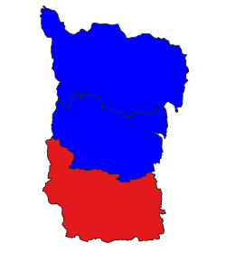 location in Falam district | |
 Falam Township Location in Burma | |
| Coordinates: 22°59′N 93°42′E / 22.983°N 93.700°E | |
| Country | |
| State | Chin State |
| District | Falam District |
| Capital | Falam |
| Population (2008)[1] | 46,883 |
| Time zone | UTC+6:30 (MST) |
Falam Township (Burmese: ဖလမ်းမြို့နယ်) is a township of Falam District in the Chin State of Burma (Myanmar). Its administrative seat is the town of Falam. The population, as of 2014, is 41,457 (male:20,350; female: 21,107). Out of this population, 9,092 live in Falam town (urban population) and 32,365 live in rural areas.[2]
Falam Township is mountainous, running east–west from the foothills above the Neyinzaya and Myittha rivers to the high peaks of the Chin Hills in the Arakan Mountain Range and down to the border with Mizoram State, India.[3] The highest peak in the township, Mount Zinghmuh[4] is also the second highest mountain peak in Chin State. The Manipur (Manipuya) River runs south through the center of the township. People who travel to the city take the Kalay-Falam-Hakha Road. The township is famous for its heart-shaped lake called Hri (Rih or Yi).[5] The township is also the location of Laiva Dam, the largest dam in Chin State. The dam produces hydroelectric power for Falam and neighboring cities such as Hakha and Thantlang (Thlangtlang).
Bridges include the Manipura river-crossing suspension bridge, 320 feet long by 5 feet wide, linking Bazan Village and Kawdah Village, and the Lonnlwe creek-crossing suspension bridge, 130 feet long by four feet wide, linking Kawdah Village and Kwabwe Village in the township.[6]
YouTube Encyclopedic
-
1/3Views:1 06235 4626 828
-
Falam Town Centre, Chin State, Myanmar
-
Ka zinna ram - Myanmar Tour (3) Chin Hills 1 @Tahan, Tedim, Falam, Hakha
-
Falam Town, Chin State
Transcription
History
In the reorganization of Chin State townships in 2008, Falam Township lost its northernmost village tracts in the east to Tiddim Township, and a few of its recently gained southwesternmost village tracts were returned to Thantlang Township, but it gained a much longer border with India by the transfer of Tiddim Township's southwestern village tracts to Fallam Township.[7]
Communities
The town of Rihkhawdar (Reehkawdar) is the northernmost town in the township.[7] The township has 87 village tracts and 178 villages.[1]
Notes
- ^ a b "Falam_Township_Profile"[permanent dead link] Myanmar Information Management Unit (MIMU), September 2009, population figures State General Administration Department, October 2008
- ^ "The 2014 Myanmar Population and Housing Census: Chin State Report" (PDF). ReliefWeb. Department of Population, Ministry of Immigration and Population. Retrieved 17 January 2022.
- ^ "1:250,000 topographic map, Series U542, Mawlaik, Burma; India, NF 46-3" U.S. Army Map Service, March 1960; and "1:250,000 topographic map, Series U542, Gangaw, Burma, NF 46-7" U.S. Army Map Service, April 1958
- ^ also known as Zing Hmuh Tlang, "Zinghmu Klang (Approved)" Falam Township at GEOnet Names Server, United States National Geospatial-Intelligence Agency
- ^ "Hri Lake (Approved)" Falam Township at GEOnet Names Server, United States National Geospatial-Intelligence Agency
- ^ http://www.mrtv3.net.mm/newpaper/2110newsn.pdf[permanent dead link] Page 10 Col 2
- ^ a b New borders and village tracts are displayed on the "Falam Township, Chin State"[permanent dead link] map, Myanmar Information Management Unit (MIMU), 6 August 2009, last accessed 28 November 2010
External links
- "Falam Township, Chin State"[permanent dead link] map, Myanmar Information Management Unit
- "Falam Google Satellite" Maplandia World Gazetteer
Capital: Hakha | ||
| Falam District | 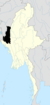 | |
| Hakha District | ||
| Matupi District | ||
| Mindat District | ||
| Cities and towns | ||