
| St Lawrence Estuary Estuaire du Saint-Laurent (in French) | |
|---|---|
 Maritime section at Port-au-Saumon | |
  | |
| Etymology | Saint Lawrence of Rome |
| Location | |
| Country | Canada |
| Province | Quebec |
| Physical characteristics | |
| Source | Saint Lawrence River |
| • location | Lake Saint-Pierre, Trois-Rivières, Quebec, Canada |
| • coordinates | 46°16′17″N 72°38′5″W / 46.27139°N 72.63472°W |
| Mouth | Gulf of St. Lawrence / Atlantic Ocean |
• location | Pointe-des-Monts, Quebec, Canada |
• coordinates | 49°08′N 67°14′W / 49.133°N 67.233°W |
• elevation | 0 m (0 ft) |
| Discharge | |
| • location | below the Saint Lawrence River |
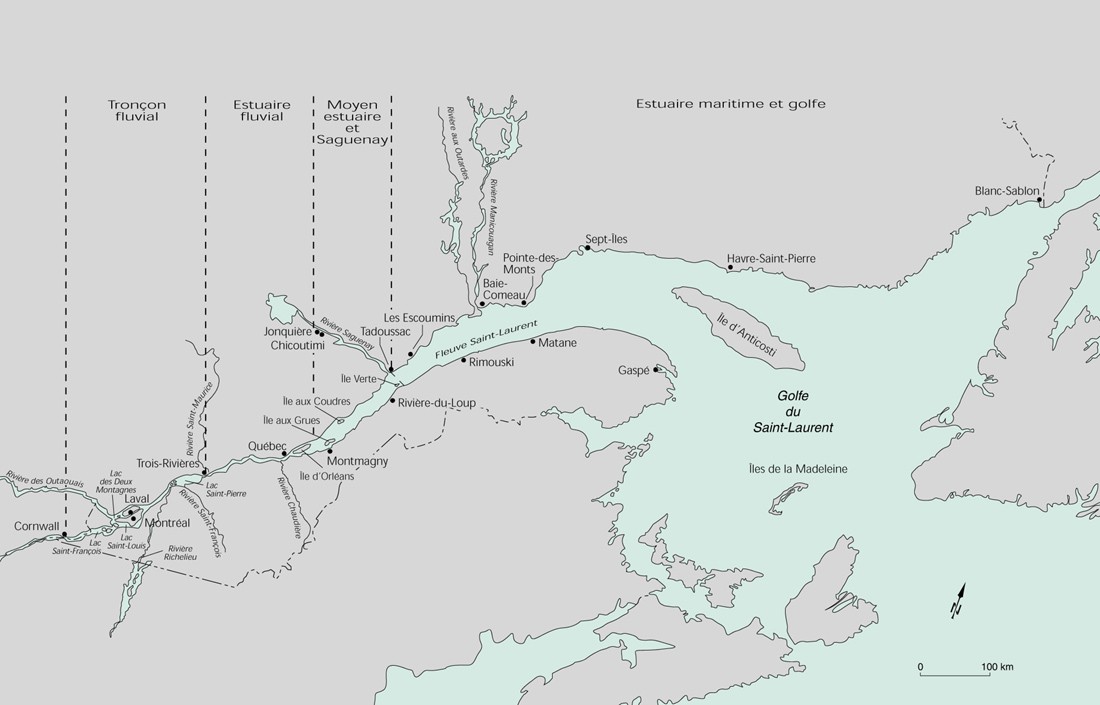
St. Lawrence Estuary stretches from west to east for 655 km, from the outlet of lake Saint-Pierre to pointe des Monts,[1] where it becomes the Gulf of St. Lawrence, in Quebec, Canada.
The estuary is divided into 3 parts, the fluvial estuary, the middle estuary and the maritime estuary.[1] [2]
YouTube Encyclopedic
-
1/3Views:589 0345 4385 601
-
A Narwhal in the St. Lawrence River
-
Battle of the St. Lawrence | Narrated by Peter Mansbridge
-
June 9, 1534: Jacques Cartier Discovers the St. Lawrence River
Transcription
Fluvial estuary

Running for about 160 km, the fluvial estuary or estuarine section of the river extends from the outlet of lake Saint-Pierre[3] to the RCM L'Islet; the portion of the river under the power of freshwater tides.
The average depth of the main channel varies from 13 to 40 m, with pools of 21 m in Trois-Rivières-Ouest and 60 m in Quebec City.[2]
Starting with lake Saint-Pierre, the ecological conditions of the St. Lawrence underwent a radical change. The slow and continuous advance of the great mass of fresh water gradually gives way to the regime of the upflow tide, where twice every twenty-four hours the shores undergo a short alternation of emersion and immersion.[4]
Flora
Between Saint-Augustin-de-Desmaures and Île aux Grues, from 2008 to 2012, three plants characteristic of the St. Lawrence freshwater estuary and in a precarious situation were monitored annually: Victorin's gentian (Gentianopsis virgata ssp. victorinii), Victorin's water-hemlock (Cicuta maculata var. victorinii) and Parker's Buckwheat (Eriocaulon parkeri).[5]
Middle estuary

Running for about 195 km, the middle estuary of the St Lawrence extends, according to the authors, from the eastern tip of Île d'Orléans or Saint-Jean-Port-Joli, to the mouth of the Saguenay River.[2]
Maritime estuary
Running for about 300 km, the maritime Estuary of the St Lawrence extend, from the mouth of Saguenay River at Tadoussac to Pointe-des-Monts were begin the Gulf.
Situation
The estuary of the St. Lawrence River is located downstream of the St. Lawrence River and upstream of the Gulf of St. Lawrence. It refers to the place where the fresh and salt waters mix between the river and the gulf. The St. Lawrence Estuary begins at Lake Saint-Pierre[6] and ends at the widening of the shores at the Pointe des Monts on the Côte-Nord to the city of Matane, opposite, in the Gaspé Peninsula, the distance is only 52 km. These points serve as a boundary between the estuary of the river upstream and the much wider Gulf of St. Lawrence downstream.[7]
The estuary is divided into sections: the St. Lawrence River estuary at Île d'Orléans (Orleans Island), the middle estuary to the Saguenay River. At this point, the St. Lawrence is characterized by a saline front at the eastern tip of Île d'Orléans.
The zone of contact between fresh and salt water corresponds to a region of high concentrations of suspended matter causing a zone of maximum turbidity (MTZ) of a length that can vary from 70 to 120 kilometres (43 to 75 mi), depending on the flow of the river.[8] This zone of maximum turbidity is located between Île d'Orléans (salinity greater than 0 PSU) and Île aux Coudres (salinity below 10 PSU). The mechanisms of estuarine circulation associated with this environment make it a privileged site of primary and secondary production which shelters many fish nurseries. High environmental turbidity provides shelter against predators while larvae are maintained under optimum temperature and salinity conditions.[9][10][11] Large variations in salinity and turbidity result in a wide variety of physicochemical conditions and planktonic communities on the river.
Fauna and flora
An emblematic species is the beluga (beluga whale), but many other species are present. An identification guide for marine fishes of the estuary and northern Gulf of St. Lawrence was completed in 2008.[12]
See also
References
- ^ a b "Pointe des Monts". Toponymy Quebec Commission (in French). Government of Quebec. 1968-12-05. Retrieved 20 February 2024.
The coastline of Pointe des Monts on the North Shore and the city of Matane, opposite, in the Gaspé Peninsula, are the points that serve as the boundary between the estuary of the St. Lawrence River upstream, and the much wider Gulf of St. Lawrence, downstream.
- ^ a b c "A river, estuaries, a gulf, the great hydrographic divisions" (PDF). Atlas of the St. Lawrence (in French). Atlas environnemental du Saint-Laurent. 1991. Retrieved 11 April 2024.
The width of the Lower Estuary varies from 24 km to Tadoussac 50 km to Pointe-des-Monts
- ^ Manon Couture (21 October 2010). "Portrait and diagnosis of the Orphan Basin Zone of southern Lake Saint-Pierre" (PDF) (in French). Organisme de concertation pour l’eau des bassins versants de la rivière Nicolet (Copernic). pp. 14 of 75.
The effect of the tides is faintly perceptible in Lake Saint-Pierre, the last freshwater basin before the estuary
- ^ Frère Marie-Victorin (1935). "St. Lawrence Estuarine Section". florelaurentienne.com (in French). pp. 53, 54. Retrieved 12 April 2024.
The estuarine section is the portion of the river under the power of freshwater tides
- ^ Hélène Gilbert (2013). "Monitoring of 3 rare plants from the St. Lawrence freshwater estuary" (PDF). Le Naturaliste canadien (in French). La Société Provancher d'histoire naturelle du Canada. p. 10. Retrieved 14 April 2024.
Monitoring was carried out between Saint-Augustin-de-Desmaures and Île aux Grues, at 10 sites where at least one of these taxa was present.
- ^ "0303-carte.jpg". Sustainable development, Environment and Park. Retrieved 27 November 2008.
- ^ "Pointe des Monts". Commission de toponymie Quebec. Gouvernement of Quebec. 1968-12-05. Retrieved 8 April 2024.
The Pointe des Monts on the North Shore, at the city of Matane, opposite, in the Gaspé Peninsula, are the points that serve as the boundary between the estuary of the river and the Gulf of St. Lawrence
- ^ Silverberg, Norman; Sundby, Bjørn (1979-04-01). "Observations in the turbidity maximum of the St. Lawrence Estuary". Canadian Journal of Earth Sciences. 16 (4): 939–950. doi:10.1139/e79-080. ISSN 0008-4077.
- ^ Sirois, P; Dodson, Jj (2000). "Critical periods and growth-dependent survival of larvae of an estuarine fish, the rainbow smelt Osmerus mordax". Marine Ecology Progress Series. 203: 233–245. doi:10.3354/meps203233. ISSN 0171-8630.
- ^ North, E. W.; Houde, E. D. (October 2001). "Retention of White Perch and Striped Bass Larvae: Biological-Physical Interactions in Chesapeake Bay Estuarine Turbidity Maximum". Estuaries. 24 (5): 756. doi:10.2307/1352883. JSTOR 1352883. S2CID 32886478.
- ^ Winkler, G; Dodson, Jj; Bertrand, N; Thivierge, D; Vincent, Wf (2003). "Trophic coupling across the St. Lawrence River estuarine transition zone". Marine Ecology Progress Series. 251: 59–73. doi:10.3354/meps251059. ISSN 0171-8630.
- ^ C. Nozères; D. Archambault; P.-M. Chouinard; J. Gauthier; R. Miller; E. Parent; P. Schwab; L. Savard; J.-D. Dutil (2010). "Identification guide for marine fishes of the estuary and northern Gulf of St. Lawrence and sampling protocols used during trawl surveys between 2004 and 2008" (PDF) (in English and French). Regional Science Branch Fisheries and Oceans Canada, Maurice Lamontagne Institute. Retrieved 8 April 2024.
Important source of information on the status of marine resources harvested in the estuary and northern Gulf of St. Lawrence.
External links
- 1998 -Année internationale des océans, Nouvelles des sciences, Institut Maurice Lamontagne, Centre de recherche en science de la mer, 10 pages (Fr)
- David Anderson, Minister of Fisheries and Oceans, at the meeting with the Quebec fishing industry in Montreal, Speech September 10, 1998. Info Oceans, 4 pages (Fr)