
 Zed Islands from Miziya Peak; Esperanto Island is the leftmost one in the background | |
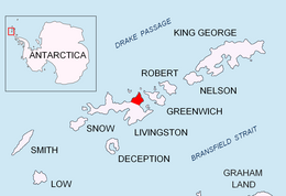 Location of Esperanto Island | |
 Esperanto Island | |
| Geography | |
|---|---|
| Location | Antarctica |
| Coordinates | 62°25′43″S 60°10′23″W / 62.42861°S 60.17306°W |
| Archipelago | South Shetland Islands |
| Area | 56 ha (140 acres) |
| Length | 0.95 km (0.59 mi) |
| Width | 0.9 km (0.56 mi) |
| Highest elevation | 290 m (950 ft) |
| Administration | |
| Administered under the Antarctic Treaty System | |
| Demographics | |
| Population | Uninhabited |
Esperanto Island is the largest and northwesternmost island in the Zed group off the north coast of Varna Peninsula on Livingston Island in the South Shetland Islands, Antarctica. The island is ice-free, rocky, rising to 290 m (951 ft) and extending 950 by 900 m (1,040 by 980 yd), with surface area 56 hectares (140 acres).[1] It is situated 70 m (77 yd) to the northwest of the neighbouring Phanagoria Island, and 2.7 km (1.7 mi) northwest of Williams Point on Livingston Island. The area was visited by early 19th-century sealers.
The island is named after the constructed international language Esperanto.
YouTube Encyclopedic
-
1/5Views:4194381 0962 696877
-
Retseminario: Esperanto in the USA
-
To the Beautiful Blue Danube
-
Menada Esperanto Apartments - Sunny Beach, Bulgaria - Review HD
-
Cigov chark - The Island, Bulgaria
-
Остров през пролетта.
Transcription
Location
Esperanto Island is located at 62°25′43″S 60°10′23″W / 62.42861°S 60.17306°W. British mapping in 1968, Chilean in 1971, Argentine in 1980, Bulgarian in 2005 and 2009.

See also
- Composite Antarctic Gazetteer
- List of Antarctic islands south of 60° S
- SCAR
- Territorial claims in Antarctica
References
- ^ L.L. Ivanov. Antarctica: Livingston Island and Greenwich, Robert, Snow and Smith Islands. Scale 1:120000 topographic map. Troyan: Manfred Wörner Foundation, 2009. ISBN 978-954-92032-6-4
- Bulgarian Antarctic Gazetteer. Antarctic Place-names Commission. (details in Bulgarian, basic data in English)
External links
- Esperanto Island. SCAR Composite Antarctic Gazetteer.
- Bulgarian Antarctic Gazetteer. Antarctic Place-names Commission. (details in Bulgarian, basic data in English)
External links
- Esperanto Island. Copernix satellite image
This article includes information from the Antarctic Place-names Commission of Bulgaria which is used with permission.

This Livingston Island location article is a stub. You can help Wikipedia by expanding it. |