


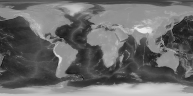
The equirectangular projection (also called the equidistant cylindrical projection or la carte parallélogrammatique projection), and which includes the special case of the plate carrée projection (also called the geographic projection, lat/lon projection, or plane chart), is a simple map projection attributed to Marinus of Tyre, who Ptolemy claims invented the projection about AD 100.[1]
The projection maps meridians to vertical straight lines of constant spacing (for meridional intervals of constant spacing), and circles of latitude to horizontal straight lines of constant spacing (for constant intervals of parallels). The projection is neither equal area nor conformal. Because of the distortions introduced by this projection, it has little use in navigation or cadastral mapping and finds its main use in thematic mapping. In particular, the plate carrée has become a standard for global raster datasets, such as Celestia, NASA World Wind, the USGS Astrogeology Research Program, and Natural Earth, because of the particularly simple relationship between the position of an image pixel on the map and its corresponding geographic location on Earth or other spherical solar system bodies. In addition it is frequently used in panoramic photography to represent a spherical panoramic image.[2]
YouTube Encyclopedic
-
1/5Views:3 572378 6421 49910 657318
-
map projections spherical to rectangular coordinates
-
Can You Make an Accurate Map?
-
Affinity Photo iPad — EQUIRECTANGULAR Projection
-
Equirectangular Projection for Sphere - UV Squares - Tutorial
-
How to Download Equirectangular Images
Transcription
Definition
The forward projection transforms spherical coordinates into planar coordinates. The reverse projection transforms from the plane back onto the sphere. The formulae presume a spherical model and use these definitions:
- is the longitude of the location to project;
- is the latitude of the location to project;
- are the standard parallels (north and south of the equator) where the scale of the projection is true;
- is the central parallel of the map;
- is the central meridian of the map;
- is the horizontal coordinate of the projected location on the map;
- is the vertical coordinate of the projected location on the map;
- is the radius of the globe.


Longitude and latitude variables are defined here in terms of radians.
Forward

The plate carrée (French, for flat square),[3] is the special case where is zero. This projection maps x to be the value of the longitude and y to be the value of the latitude,[4] and therefore is sometimes called the latitude/longitude or lat/lon(g) projection. Despite sometimes being called "unprojected",[by whom?] it is actually projected.[citation needed]
When the is not zero, such as Marinus's ,[5] or Ronald Miller's ,[6] the projection can portray particular latitudes of interest at true scale.


While a projection with equally spaced parallels is possible for an ellipsoidal model, it would no longer be equidistant because the distance between parallels on an ellipsoid is not constant. More complex formulae can be used to create an equidistant map whose parallels reflect the true spacing.
Reverse

Alternative names
In spherical panorama viewers, usually:
where both are defined in degrees.
See also
- Cartography
- Cassini projection
- Gall–Peters projection (mentions a resolution rejecting the use of all rectangular world maps)
- List of map projections
- Mercator projection
- 360 video projection
- Wikimedia Gallery of Equirectangular World Maps
References
- ^ Flattening the Earth: Two Thousand Years of Map Projections, John P. Snyder, 1993, pp. 5–8, ISBN 0-226-76747-7.
- ^ "Equirectangular Projection - PanoTools.org Wiki". wiki.panotools.org. Retrieved 2021-05-04.
- ^ Farkas, Gábor. "Plate Carrée - a simple example". O’Reilly Online Learning. Retrieved 31 December 2022.
- ^ Paul A. Longley; Michael F. Goodchild; David J. Maguire; David W. Rhind (2005). Geographic Information Systems and Science. John Wiley & Sons. p. 119. ISBN 9780470870013.
- ^ Flattening the Earth: Two Thousand Years of Map Projections, John P. Snyder, 1993, pp. 7, ISBN 0-226-76747-7.
- ^ "Equidistant Cylindrical (Plate Carrée)". PROJ coordinate transformation software library. Retrieved 25 August 2020.
- ^ "Yaw - PanoTools.org Wiki". wiki.panotools.org. Retrieved 2021-05-04.
- ^ "Pitch - PanoTools.org Wiki". wiki.panotools.org. Retrieved 2021-05-04.
External links
- Global MODIS based satellite map The blue marble: land surface, ocean color, and sea ice.
- Table of examples and properties of all common projections, from radicalcartography.net.
- Panoramic Equirectangular Projection, PanoTools wiki.
- Equidistant Cylindrical (Plate Carrée) in proj4