
El Verger | |
|---|---|
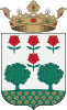 Coat of arms | |
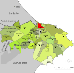 | |
 El Verger Location in Spain | |
| Coordinates: 38°50′34″N 0°0′34″E / 38.84278°N 0.00944°E | |
| Country | |
| Autonomous community | |
| Province | Alicante |
| Comarca | Marina Alta |
| Judicial district | Dénia |
| Government | |
| • Alcalde | Ximo Coll (PSOE) |
| Area | |
| • Total | 8.16 km2 (3.15 sq mi) |
| Elevation | 25 m (82 ft) |
| Population (2018)[1] | |
| • Total | 4,520 |
| • Density | 550/km2 (1,400/sq mi) |
| Demonym(s) | Vergerí, vergerina Vergerer, vergerera |
| Time zone | UTC+1 (CET) |
| • Summer (DST) | UTC+2 (CEST) |
| Postal code | 03770 |
| Official language(s) | Valencian |
| Website | Official website |
El Verger (Valencian pronunciation: [el veɾˈdʒeɾ]; Spanish: Vergel [beɾˈxel]) is a town of 4,992 inhabitants situated 3 kilometres from the Mediterranean Sea and 8 kilometres from Dénia, in the Comarca of Marina Alta, Valencian Community, Spain. The main attractions are the Main Street, two medieval towers and a neoclassical church. The town's crest, recently resuscitated, pays homage to its name: it displays two trees and four flowers.
The Prime Meridian crosses El Verger.
YouTube Encyclopedic
-
1/4Views:10 2126 773572582
-
EL VERGER. Alicante pueblo a pueblo
-
El Verger (Dénia)
-
EL VERGER 2012 - Moros i Cristians
-
Festers El Verger 2009
Transcription
Geography

The municipal boundaries confront those of Beniarbeig, Benimeli, Murla, Dénia, Ondara and Els Poblets. The town is 91 km from both Alicante and Valencia, and constitutes part of the frontier between the Province of Alicante and that of Valencia. The Mediterranean is 3 kilometres to the northeast. The town is split in two by the river Girona, which flooded catastrophically in 2007, destroying many houses and taking a life. The largest part of El Verger is to be found on the western side of the river, and three bridges provide access to the other side and to the sea beyond. Behind El Verger lies the Segària mountain range, a place popular for hiking and which gives the local school its name. A large part of the surrounding lands is dedicated to agriculture, specifically vegetables and citrus fruits.
References
- ^ Municipal Register of Spain 2018. National Statistics Institute.
External links
- El Verger townhall (in Catalan)
- Municipal band website (in Catalan)
- El Verger's Moors and Christians website (in Catalan)
- Photos of the 2007 flood in El Verger
Gallery
-

Segària, El Verger's mountain.
-

The river Girona at the height of El Verger.
-

Orange groves in El Verger.
-

Photo of the damage done by the flood of October 2007, El Verger
-

La Fàbrica de Sabó (The Soap Factory), El Verger's cultural centre
| International | |
|---|---|
| Geographic | |