
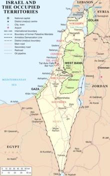
The modern borders of Israel exist as the result both of past wars and of diplomatic agreements between the State of Israel and its neighbours, as well as an effect of the agreements among colonial powers ruling in the region before Israel's creation. Only two of Israel's five total potential land borders are internationally recognized and uncontested, while the other three remain disputed; the majority of its border disputes are rooted in territorial changes that came about as a result of the 1967 Arab–Israeli War, which saw Israel occupy large swathes of territory from its rivals.[1] Israel's two formally recognized and confirmed borders exist with Egypt and Jordan since the 1979 Egypt–Israel peace treaty and the 1994 Israel–Jordan peace treaty, while its borders with Syria (via the Israeli-occupied Golan Heights), Lebanon (via the Blue Line; see Shebaa Farms dispute) and the Palestinian territories (Israeli-occupied land largely recognized as part of the de jure State of Palestine) remain internationally defined as contested.[2]
According to the Green Line agreed upon in the 1949 Armistice Agreements, Israel is demarcated by Lebanon to the north, the Golan Heights under Syrian sovereignty as well as the rest of Syria to the northeast, the Palestinian West Bank and Jordan to the east, and by the Palestinian Gaza Strip and Egypt to the southwest. The Israeli border with Egypt is the international border demarcated in 1906 between the United Kingdom and the Ottoman Empire, and confirmed in the 1979 Egypt–Israel peace treaty; the Israeli border with Jordan is based on the border defined in the 1922 Trans-Jordan memorandum, and confirmed in the 1994 Israel–Jordan peace treaty.
YouTube Encyclopedic
-
1/4Views:11 6666144 60254 404
-
The Borders of Israel (Essential Lectures in Jewish History) Dr. Henry Abramson
-
JCPA - Defensible Borders
-
Biblical Israel's Georgraphical Borders in AFRICA
-
The Middle Eastern Country That Has No Borders
Transcription
Hello. Today we're going to speak about a very complex and controversial topic the borders of Israel this is something that a lot of people have a lot of hard feelings over obviously is one of the major geopolitical conflicts of the 20th and century in going into the 21st century and so I'm gonna try very hard just to walk you through the border changes which obviously depend heavily on war and peace but I'll try to avoid the kind language that exacerbates tensions you may find that depending on where you wander around the web to find people using very different terminology I'm gonna try just keep the neutral terminology for now perhaps I'll point out some those flash points as we go along but an eerie let's get straight into really borders the state Israel in the 20th century alright so it's important to understand that there's a difference between the State of Israel and the land of Israel the land of Israel or huber et cetera et al is a very old concept that goes all the way back obviously to the Bible the Jews have historically regarded the line Israel as their homeland and even after an exile 6 entry before the Common Era and then again the for centuries a common error they've always had central to their vision up the history the world there ultimate return to Israel under a masai and this is something that was shared by much a Western culture in fact if you look at this really interesting map you see that jerusalem is portrayed as the center are the known world with Europa Asia and Africa all converging on Jerusalem the holy city with america way of in the side so this is something that was central to really jewish Christian and Islamic history for most up the known history the world in the late nineteenth century and certainly in the early 20th century there was a strong movement jus to resettle and as you see it with these come sought or a female pioneers were going back to Israel to reclaim the land or choose to engage in farming and things like that up until the late 19th century there were always small settlements jus particularly in places like jerusalem words spot stop it but that there was no wide-scale organized movement to choose to settle and until this time late 19th century obviously the land was not completely follow there were non-jews were living in the land of Israel and that meant when the political aspirations I love the immigrant Jews clashed with the aspirations of both the indigenous non-jewish populations and those non-jews Arabs who moved into the region as a result of the increasing economic I'll opportunities afforded by this immigration these would come to tremendous conflict over 20 century that's really the beginnings up the modern history conflict between arabs and Jews so if we look at the political map or all we're trying to do today is just look at the shape up the borders Israel from the its beginnings in the twentieth century to the beginning of the 21st century up Israel starts out at the beginning centuries part up the Ottoman Empire as you can see this large swap territory because all across North Africa right through the middle east up into Turkey and into parts of Europe jerusalem is I really significant point in the the map because of course it is a a crossroads between the various sections up the Ottoman Empire but the Ottoman Empire was not asked the sick man of Europe by the end of the 19th century was clear that this was a holdover medieval times and would not survive any large conflagration which would come to pass in world war 1 at this time coming up to a month he died before the work breakout however there was a tremendous efforts are Theodor Herzl shown here who was an Austrian Jew who believes very strongly in the political mobilization jus to resettle and it is wrong create homeland for the Jews there primarily as a refuge for anti-semitism and as a kind of normalization I love their status because up until this point they were you know all over Europe and I were a minority a where so they're doing hands-on never got to see his vision put in place in land Israel but after world war 1 with the collapse under the Ottoman Empire the British took over the region Israel and as we should be trained Jordan and after handing it over to the united nations or known as the League of Nations at that time excuse me they divided up the territory as follows: here's a really important map CC the sorter bluish grayish area on the left that is the British Mandate section that was handed over to and bench will possible area for jewish settlement this is in keeping with the British promise in 1917 in the Balfour Declaration to guarantee a homeland for the Jews in region without prejudice to the indigenous population trying to really do both things at once on the one hand a home after the jews and at the same time not prejudicing the civil and religious rights up the indigenous populations largely an impossible thing to achieve on the right you see trends Jordan which was ultimately handed over to the the Kings have Jordan and became a separate country and at the top you see a little red area which is the Golan Heights a mountainous region handed over to Syria you can also notice you look carefully this map that a lot of these lines are strangely straight as if they're drawn with rulers and in fact that is what they did when the great powers got together to divide up the middle east the basically made political calculations and divided them up according to their home political agenda but any rate this is the first map that we're doing with cuz we see we have on the left here the region that was reserved for some area are jewish settlement and eventual homeland as 19 20 to moving on we're here I'm what ends up happening is a lot of conflict between the jus and arabs and the British occupying authorities this accelerates throughout the 1920s and 1930s and after the holocaust after world war two the pressures are just phenomenal there's a lot are demands for jewish immigration into the region I the our population has also increased significantly this point and their requests for break put on that immigration and ultimately the British decide to hand it over to the United Nations much like they had over the question what to do with India the United Nations in 1947 they come with this rather disastrous partition plan you see here on the left United Nations resolution one 81 and that basically divides up what is contemporary Israel into 7 distinct regions three regions shown here in a kinda bluish gray which were to be for the proposed Jewish state for Israel three regions which are for a proposed Arab state see those are the kinda no while wanted the pics change colors have a brownish color and then right in the centre you have jerusalem which was simply too hot to handle no one could agree as to what to do with it so therefore the set it aside as a kind international zone a corpus so far autumn or a separate body should be handled somewhat differently the bottom line with this map the 1947 map is that the jus accepted this partition plan the Arab countries surrounding the region that is Egypt Jordan Lebanon and Syria did not accept it and they invaded israel and there was a huge war now again I'm not gonna go into the specifics of the war i won the most significant out aspects of it was there was military change that drove populations out in the region particularly Arabs were driven out and they're also you know political boundary changes which is what we're going to focus on here again larger ramifications are these changes are significant and still par the conflict but just looking at the boundaries you see that the I the the israelis now because we're talking about the state of israel as a 1948 when the war broke out the State of Israel actually expansive its borders not only did they successfully defend their territory the actually expanded into the areas shown here in purple so they're able to consolidate the northern region at the galileo and they were able to expand the Negev region but they were not able when it very significantly they were able to push right the boundaries our jerusalem but jerusalem remained a divided city with the eastern half East Jerusalem har Jordan and heavily populated by arabs the western half occupied now by Israel and down heavily-populated obviously by jews they're kinda sermon apartheid movement as population shifted across that border I'll the did not conquer what was called the West Bank so called because is on the west bank up the Jordan River also known as Yehuda and Shomron and then they did not conquer the Gaza Strip down in the lower left corner up the boundary so that's basically what Israel look like from 1949 until the next major conflict which was nineteen sixty-seven there were minor conflicts or or significant but not boundary changes conflicts between then but the 1967 Six Day War is really crucial basically what happened 67 is that each chipped in particular along with syria as well and the other Arab countries around it planned in massive invasion Israel in June 1967 it was very clear that innovation was about to happen the UN was powerless or perhaps even willing to invest energy in stopping this conflagration and what Israel did in a very controversial move but ultimately very successful for the fledgling Jewish state they launched a preemptive strike and gates their Arab enemies and this was an extremely successful war for Israel hence it's called the six-day war and not only did Israel contain its own territory as in 1949 actually expanded tremendously it was really an amazing victory for the israelis I'm now looking at this map here you see that they did two different things with the territory's that the Concord the territories on the there a label on left were occupied the those are the huge Sinai Peninsula which borders on Egypt largely a desert but nevertheless is is very important buffer region for military attacks the Gaza Strip which is I like the Sinai Peninsula highly populated and finally the region we know is the West Bank was occupied and the thank you wise occupied for now until we figure out what to do with it a lot israelis believe that a phone call would calm almost immediately from the defeated Arab states saying fine let's make peace let's go beyond what was million armistice and that is a cease-fire in 1949 and lettuce actually solidify our relationship and you will have the right to exist and we will have secure borders that phone call did not com but those regions were site kindly waiting to be dealt with in the case in the Sinai Peninsula as we shall see it was ultimately given to Egypt in exchange for a peace treaty but no such arrangement was made ultimately for the West Bank and the Gaza Strip now those are areas which are occupied Sinai Peninsula Gaza Strip and the West Bank two regions were annexed in this is quite distinct from occupied annexed means that these regions were formally incorporated permanently into the territories Israel and those two regions are East jerusalem which has a incredible spiritual political and emotional significance for jews as well as for the arabs living this region work now using the term palestinian specifically defined the indigenous populations on and also the golan heights which has military significance because it's a mountainous region that overlooks the lowlands in Syria to the North East and overlooks the lowlands and Israel to the Southwest so whoever controls the golan heights as a lease with conventional weapons a huge military manage so those regions were permanently at next to state Israel up but the occupied territories were still waiting for a some kinda final resolution on much of that resolution occurred in 1978 when anwar sadat shown here famous photograph shaking hands with his is interlocutor menachem Bay in the Prime Minister Israel with the American President Jimmy Carter in the center I'll called up each other and they ultimately made a peace treaty that peace treaty and was between Egypt and Israel obviously and the main territorial concession on israel's par wise to give up the Sinai Peninsula as you can see in this map I it was ceded to Egypt its the reeks stages zone a be and see was not an extremely difficult thing for israel to do because was largely unpopulated although there were some extremely emotional moments for israelis who fell that the gaza territory should be retained and had begun settling their the Gaza Strip however was not something that Egypt wanted to reklame and so it remained under israeli occupation I very difficult stand status for it to occupy both for the Gaza and Palestinians and also ultimately for the israeli occupiers up that territory another change happens in 1993 when after the fall of the Soviet Union changes a lot of the geopolitical dynamic up the region are gets cock Robin shown here the Prime Minister Israel on the left reaches out to his counterpart yasser arafat had up the Palestine Liberation Organization and with the sponsorship are American President Jimmy Carter center they also have another classic photoshoot shaking hands and that result in a peace treaty that's not nearly as successful as the one that Israel as with Egypt basically this creates a palestinian autonomy or Houston authority and the thinking wise that this would be a roadmap this is a term that many the Western powers use erode map to an eventual two-state solution I Israel and Palestine living side by side with secure borders and they looked at the map with Israel and specifically look that demographic density up the West Bank and the Gaza Strip in particular and the thinking was that are as are so certain about territory will be given over to palestinian control and with trust-building measures on both sides ultimately that authority will expand an expanded till ultimately there was a Palestinian state those trust-building measures did not work there was a a lot of internal fighting among the palestinians in both gaza and the West Bank and with both regions there was a lot of hard feelings for the israelis particularly when the construction of a huge wall began to separate israel proper from be West Bank which was felt by many palestinians to be and unfair irrigation territories Israel and ultimately the palestinian authority has not succeeded in now overcoming the objections to its existence and ultimately Israel on and the Palestinians have yet to formalized anything year a two-state solution and this is before we even talk about jerusalem which is hotly contested as the capital %uh both the State of Israel and the potential state of Palestine on nor does it address the issue up the return up the refugees from the 1948 1949 war and their descendants many of whom are still living in refugee camps in Arab states surrounding land of Israel so its has not been a success like the original egypt has been success the last major political change up until the point when I'm recording this video is the controversial disengagement from Gaza that was affected in 2005 under Prime Minister Aria sure on the Gaza Strip as I've been to made it over this lecture is always been a very problematic territory for Israel Jews are highly outnumbered in this densely-populated and and very close quarters urban region now there were several successful economic ventures run by israeli in the Gaza Strip but the cost of me in those settlements and the both in terms of materiel financial resources and also to a certain degree the political will are most israelis who viewed many of the settlers up gaza the Jews with settled in gaza to be ideologically very radical and not representing the best interests of Israel when it comes to an eventual peace treaty with the palestinians are also ron looked also at the demographic factors that the Palestinians were be producing at a much higher rate higher birthrate that israelis and ultimately the problem other demographic imbalance between jews and Palestinians in Gaza was only going to get worse that also is combined with the fact that Gaza has a much more radical political climate the West Bank and in fact Gaza and went the West Bank I are still at war with each other as a record this video and so ultimately our restaurant made the controversial decision to simply remove all troops from Gaza and Israel still controls its borders which is found to be very difficult for the Gazans living there their blockades for example love various ships don't wanna bring aid to Gaza Israel contends that they're bringing military aid as well as humanitarian aid so gazans is in a very dire situation with no clear outlet at as a time recordings soap we look at the map in israel kinda summary here you see basically what happened is on the left this is sorta what it look like before israel was the state has called this map palestine trans Jordan because this region was given to the British by the League of Nations to determine how to sort out the claims up the jus and the Arabs who wanted this territory that in the center map you have I the 1947 plan which is kinda the yellow and then after the war of 1948 49 the orange territories are eyes given to you Israel or the orange territories are are taken over by Israel and then in 1967 which is not shown here the out west bank the Gaza Strip which is not labeled and the Sinai Peninsula as well as the golan heights up toward Syria is conquered by Israel and down then on the map on the right you see what it looks like basically just before 2005 I'll Egypt gets the Sinai peninsula back as a result of their 1978 peace treaty the golan heights is taken over by Israel and annexed along with East Jerusalem is happening 1967 also shown here once we look at the top of the map lebanon is a very destabilizing country in the region and the israelis I did find a couple of workers with lebanon and so the established a security zone there which is not consider part israel proper by anyone although it definitely is controlled by Israel so the West Bank still remains under israeli-controlled with some regions that have some light on me under the palestinian authority the Gaza Strip shown here is simply abandoned by Israel 2005 always still control the borders and that's basically what Israel looks like today okay very complicated topic I am very he did kinda topic but I hope that just looking at the map so give us some sense are how the political contours of the conflict involved over the 20th century and let's hope for peace in the Middle East okay I hope you found that information useful and or speak with you
Early background
The Sykes–Picot Agreement of 1916 secretly divided the Ottoman Empire lands of Middle East between British and French spheres of influence. They agreed that "Palestine" was to be designated as an "international enclave".[3] This agreement was revised by Britain and France in December 1918; it was agreed that Palestine and the Vilayet of Mosul in modern-day Iraq would be part of the British sphere in exchange for British support of French influence in Syria and Lebanon.[4] At the San Remo Conference (April 19–26, 1920) the Allied Supreme Council determined that mandates for Palestine and Mesopotamia would be allocated to Britain without precisely defining the boundaries of the mandated territories.[5][6]
Border with Jordan
British Mandate
![March 12, 1921 British memorandum explaining the situation of Transjordan: "His Majesty's Government have been entrusted with the Mandate for "Palestine." If they wish to assert their claim to Trans-Jordan and to avoid raising with other Powers the legal status of that area, they can only do so by proceeding upon the assumption that Trans-Jordan forms part of the area covered by the Palestine Mandate. In default of this assumption Trans-Jordan would be left, under article 132 of the Treaty of Sèvres, to the disposal of the principal Allied Powers."[9]](/wikipedia/commons/thumb/2/23/Cair_Conference_12_March_memo_regarding_Transjordan.jpg/217px-Cair_Conference_12_March_memo_regarding_Transjordan.jpg)
![March 12, 1921 British memorandum explaining the situation of Transjordan: "His Majesty's Government have been entrusted with the Mandate for "Palestine." If they wish to assert their claim to Trans-Jordan and to avoid raising with other Powers the legal status of that area, they can only do so by proceeding upon the assumption that Trans-Jordan forms part of the area covered by the Palestine Mandate. In default of this assumption Trans-Jordan would be left, under article 132 of the Treaty of Sèvres, to the disposal of the principal Allied Powers."[9]](/wikipedia/commons/thumb/9/90/British_Government_memorandum_regarding_Article_25_of_the_Palestine_Mandate_with_respect_to_Transjordan%2C_25_March_1921.jpg/217px-British_Government_memorandum_regarding_Article_25_of_the_Palestine_Mandate_with_respect_to_Transjordan%2C_25_March_1921.jpg)
In March 1921, the Colonial Secretary Winston Churchill visited Jerusalem and following a discussion with Emir Abdullah, it was agreed that Transjordan was to be added to the proposed Palestine Mandate, but that the Jewish National Home objective for the proposed Palestine Mandate would not apply to the territory.
In July 1922, the League of Nations approved the Palestine Mandate, which came into effect in 1923 after a dispute between France and Italy over the Syria Mandate was settled. The Mandate stated that Britain could 'postpone or withhold' application of the provisions dealing with the 'Jewish National Home' in the territory east of the Jordan River, then called Transjordan. In September 1922, following Abdullah's probation period,[10] the British government presented a memorandum to the League of Nations defining the border of Transjordan and confirming its exclusion from all the provisions dealing with Jewish settlement.
Historian and political scientist Adam Garfinkle writes that the public clarification and implementation of Article 25, more than a year after its addition to the Mandate, misled some "into imagining that Transjordanian territory was covered by the conditions of the Mandate as to the Jewish National Home before August 1921".[b] This would, according to professor of modern Jewish history Bernard Wasserstein, result in "the myth of Palestine's 'first partition' [which became] part of the concept of 'Greater Israel' and of the ideology of Jabotinsky's Revisionist movement".[c][d] Palestinian-American academic Ibrahim Abu-Lughod, then chair of the Northwestern University political science department, suggested that the "Jordan as a Palestinian State" references made by Israeli spokespeople may reflect "the same [mis]understanding".[e][14]
Independence
Transjordan gained independence from Britain in 1946 within the above borders, prior to the termination of Mandatory Palestine .[15]
On 15 May 1948, the Transjordanian Arab Legion entered from the east what had been the Palestinian part of the Palestinian Mandate, while other Arab armies invaded other parts of the territory. The 1948 Arab–Israeli War was brought to an end by the Lausanne Conference of 1949 at which the 1949 Armistice Agreements were concluded. The resulting armistice line is commonly referred to as the Green Line, and was expressly declared to be a temporary demarcation line, rather than a permanent border, and the Armistice Agreements relegated the issue of permanent borders to future negotiations. After the armistice, Transjordan was in control of what came to be called the West Bank. East Jerusalem, including the Old City, was considered part of the West Bank.
The West Bank was annexed by Jordan in 1950,[16] with the border being the 1949 armistice line, though Jordan laid claim to all of Mandate Palestine. Jordan's annexation was only recognised by three countries. The West Bank remained part of Jordan until Israel captured it in 1967, during the Six-Day War, though Jordan continued to claim the territory as its own after that date. In July 1988, Jordan renounced all claims to the West Bank,[17][18] in favour of the Palestinian Liberation Organisation, as the "sole legitimate representative of the Palestinian people".[19]
The Israel–Jordan peace treaty, signed on 26 October 1994, resolved all outstanding territorial and border issues between the two countries that had existed since the 1948 War. The treaty specified and fully recognized the international border between Israel and Jordan, with Jordan confirming its renunciation of any claim to the West Bank. Upon its signing, the Jordan and Yarmouk Rivers, the Dead Sea, the Emek Ha'arva/Wadi Araba and the Gulf of Aqaba were officially designated as the borders between Israel and Jordan and between Jordan and the territory occupied by Israel in 1967.[20] For the latter, the agreement requires that the demarcation use a different presentation, and that it carry the following disclaimer:
This line is the administrative boundary between Jordan and the territory which came under Israeli military government control in 1967. Any treatment of this line shall be without prejudice to the status of the territory.[21]
Border with Syria and Lebanon
French Mandate: Paulet–Newcombe Agreement
The Paulet–Newcombe Agreement, a series of agreements between 1920 and 1923, contained the principles for the boundary between the Mandates of Palestine and Mesopotamia, attributed to Great Britain, and the Mandate of Syria and the Lebanon, attributed to France.
A 1920 agreement defined the boundary between the forthcoming British and French mandates in broad terms,[22] and placed the bulk of the Golan Heights in the French sphere. The agreement also established a joint commission to settle the border and mark it on the ground.[22] The commission submitted its final report on February 3, 1922, and it was approved with some caveats by the British and French governments on March 7, 1923,[23] several months before Britain and France assumed their Mandatory responsibilities on September 29, 1923.[24] In accordance with the same process, a nearby parcel of land that included the ancient site of Dan was transferred from Syria to Palestine early in 1924. In this way the Golan Heights became part of the French Mandate of Syria. When the French Mandate of Syria ended in 1944, the Golan Heights remained part of the newly independent state of Syria.
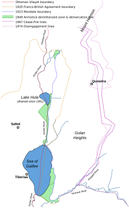
In 1923, an agreement between the United Kingdom and France, known as the Paulet–Newcombe Agreement, established the border between the soon-to-be formalised territories covered by the British Mandate for Palestine and the French Mandate for Syria.[23] The border was drawn so that both sides of the Jordan River and the whole of the Sea of Galilee, including a 10-metre-wide strip along the northeastern shore, were part of Palestine.[25][26] The agreement added 227 square kilometers to the area of Palestine.[27]
Syria: subsequent changes
The 1947 UN Partition Plan allocated this territory to the Jewish state. Following the 1948 Arab–Israeli War, Syria seized some land that had been allocated to the Jewish state and under the 1949 Armistice Agreements with Israel retained 66 square kilometers of that territory in the Jordan Valley that lay west of the 1923 Palestinian Mandate border (marked green on Map 4).[28] These territories were designated demilitarized zones (DMZs) and remained under Syrian control (marked as DMZs on the map). It was emphasised that the armistice line was "not to be interpreted as having any relation whatsoever to ultimate territorial arrangements." (Article V)
During the Six-Day War (1967), Israel captured the territory as well as the rest of the Golan Heights, and subsequently repelled a Syrian attempt to recapture it during the Yom Kippur War (1973). Israel annexed the Golan Heights in 1981 with the Golan Heights Law.[29] Israel began building settlements throughout the Golan Heights, and offered the Druze and Circassian residents citizenship, which most turned down. Today, Israel regards the Golan Heights as its sovereign territory, and a strategic necessity.[citation needed] The Purple Line marks the boundary between Israel and Syria. Israel's unilateral annexation has not been internationally recognized, and United Nations Security Council Resolution 242 refers to the area as Israeli-occupied.
During the 1990s, there were constant negotiations between Israel and Syria regarding a mediation of conflicts and an Israeli withdrawal from the Golan Heights but a peace treaty did not come to fruition.[30] The main stumbling block seems to involve the 66 square kilometers of territory that Syria retained under the 1949 armistice agreement.[28] Arab countries support Syria's position in the formula which calls on Israel "to return to the 1967 borders". (See 2002 Arab Peace Initiative)
Lebanon conflict

On March 14, 1978, Israel launched Operation Litani, occupying the area south of the Litani River, excepting Tyre (see Map 5). In response to the invasion, the UN Security Council passed Council Resolution 425 and Resolution 426 calling for the withdrawal of Israeli forces from Lebanon. Israeli forces withdrew later in 1978, but turned over their positions inside Lebanon to their ally, the South Lebanon Army (SLA).[citation needed]
The United Nations in June 2000 was called upon to decide the Lebanese border to determine whether Israel had fully withdrawn from Lebanon in compliance with UN Security Council Resolution 425. This line came to be called the Blue Line. At the same time, the United Nations did not have to consider the legality of the boundary between Lebanon and the Israeli-controlled Golan Heights, as that was not required for the purpose of Council Resolution 425. Accordingly, the Armistice Demarcation Line between Lebanon and the Israeli-controlled Golan Heights is expressly not to be called the Blue Line.[citation needed]
The Blue Line, which the UN had to determine, was the line of deployment of the IDF before March 14, 1978, when Israel invaded Lebanon. In effect that line was recognised by both Lebanon and by Israel as the international border, and not just as the Armistice Demarcation Line of 1949[citation needed] (what is commonly called the Green Line) following the 1948 Arab–Israeli War.[citation needed]
On April 17, 2000, Israel announced that it would withdraw its forces from Lebanon. The Lebanese government refused to take part in marking the border. The UN thus conducted its own survey based on the line for the purpose of Council Resolution 425, which called for "strict respect for the territorial integrity, sovereignty and political independence of Lebanon within its internationally recognized boundaries".[citation needed]
From May 24 to June 7, 2000, the UN Special Envoy heard views in Israel, Lebanon and Syria. The United Nations cartographer and his team, assisted by UNIFIL, worked on the ground to identify a line to be adopted for the practical purposes of confirming the Israeli withdrawal. While it was agreed that this would not be a formal border demarcation, the aim was to identify a line on the ground closely conforming to the internationally recognized boundaries of Lebanon, based on the best available cartographic and other documentary evidence. On May 25, 2000, Israel notified the Secretary-General that it had redeployed its forces in compliance with Council Resolution 425, that is to the Internationally recognized Lebanese border. On June 7, the completed map showing the withdrawal line was formally transmitted by the force commander of UNIFIL to his Lebanese and Israeli counterparts. Notwithstanding their reservations about the line, the governments of Israel and Lebanon confirmed that identifying this line was solely the responsibility of the United Nations and that they would respect the line as identified.[citation needed]
On June 8, 2000, UNIFIL teams commenced the work of verifying the Israeli withdrawal behind the line.[citation needed]
The Blue Line
The Blue Line identified by the United Nations in 2000 as the border of Lebanon, from the Mediterranean Sea to the Hasbani River, closely approximates the Green Line set under the 1949 armistice agreement between Lebanon and Israel.[31] The area east of the Hasbani River is considered part of Syria and included in the Golan Heights.[citation needed]
The armistice agreement between Lebanon and Israel was signed on March 23, 1949. The main points were:[citation needed]
- The terms of the agreement were dictated exclusively by military considerations.
- The armistice line (i.e., "Green Line") was the international border, which corresponds to the 1923 Mandate border between the Lebanon and Palestine (see: Treaty of Sèvres).
- Unlike the other Green Line agreements, it contains no clause disclaiming this line as an international border, and was thereafter treated as it had been previously, as the de jure international border of Lebanon.
- Israel withdrew its forces from 13 villages in Lebanese territory, which were occupied during the war.
In 1923, 38 boundary markers were placed along the 78-kilometre (48-mile) boundary and a detailed text description was published.[32] The 2000 Blue Line differs in about a half dozen short stretches from the 1949 line, although never by more than 475 metres (1,558 ft).[citation needed]
Between 1950 and 1967, Israeli and Lebanese surveyors managed to complete 25 non-contiguous kilometers and mark (but not sign) another quarter of the international border.[citation needed]
On June 16, the Secretary-General reported to the Security Council that Israel had withdrawn its forces from Lebanon in accordance with Council Resolution 425 and met the requirements defined in his report of May 22, 2000.[33] The withdrawal line has been termed the Blue Line in all official UN communications since.[citation needed]
Conflict over the Shebaa Farms

The Shebaa Farms conflict stems from Israel's occupation and annexation of the Golan Heights, with respect to that territory's border with Lebanon. Both Lebanon and Syria were within the French Mandate territory between 1920 and the end of the French Mandate in 1946. The dispute over the sovereignty over the Shebaa Farms resulted in part from the failure of French Mandate administrations, and subsequently from the failure of the Lebanon and Syria to properly demarcate the border between them.
Documents from the 1920s and 1930s indicate that some local inhabitants regarded themselves as part of Lebanon, for example paying taxes to the Lebanese government. But French officials at times expressed confusion as to the actual location of the border.[34] One French official in 1939 expressed the belief that the uncertainty was sure to cause trouble in the future.
The region continued to be represented in the 1930s and 1940s as Syrian territory, under the French Mandate. Detailed maps showing the border were produced by the French in 1933, and again in 1945.[35] They clearly showed the region to be in Syria.
After the French Mandate ended in 1946, the land was administered by Syria, and represented as such in all maps of the time.[36] The maps of the 1949 armistice agreement between Syria and Israel also designated the area as Syrian.
Border disputes arose at times, however. Shebaa Farms was not unique; several other border villages had similar discrepancies of borders versus land ownership. Syria and Lebanon formed a joint Syrian–Lebanese border committee in the late 1950s to determine a proper border between the two nations. In 1964, concluding its work, the committee suggested to the two governments that the area be deemed the property of Lebanon, and recommended that the international border be reestablished consistent with its suggestion. However, neither Syria nor Lebanon adopted the committee's suggestion, and neither country took any action along the suggested lines. Thus, maps of the area continued to reflect the Farms as being in Syria.[36] Even maps of both the Syrian and Lebanese armies continued to demarcate the region within Syrian territory (see map[which?]).[36]
A number of local residents regarded themselves as Lebanese, however. The Lebanese government showed little interest in their views. The Syrian government administered the region, and on the eve of the 1967 war, the region was under effective Syrian control.[citation needed]
In 1967, most Shebaa Farms landowners and (Lebanese) farmers lived outside the Syrian-controlled region, across the Lebanon-Syrian border, in the Lebanese village of Shebaa. During the Six Day War in 1967, Israel captured the Golan Heights from Syria, including the Shebaa Farms area. As a consequence, the Lebanese landowners were no longer able to farm it.[37]
Israel—Lebanon maritime border
As of April 2021, there was an ongoing dispute over the Mediterranean Sea border between Israel and Lebanon. Negotiations on the maritime border commenced in October 2020[38] and led to success, i.e. both sides reaching and ratifying an agreement in 2022.
Border with Egypt


A border between the Ottoman Empire and British controlled Khedivate of Egypt was drawn in the Ottoman–British agreement of October 1, 1906, after a military crisis earlier that year.[39]
According to the personal documents of the British colonel Wilfed A. Jennings Bramley, who influenced the negotiations, the border mainly served British military interests—it furthered the Ottomans as much as possible from the Suez Canal, and gave Britain complete control over both Red Sea gulfs—Suez and Aqaba, including the Straits of Tiran. At the time, the Aqaba branch of the Hejaz railway had not been built, and the Ottomans therefore had no simple access to the Red Sea. The British were also interested in making the border as short and patrollable as possible, and some contest that it did not take into account the needs of the local residents in the negotiations,[40] although its clauses did allow free access to the water sources west of the line to civilians, military and gendarmes from the Ottoman side, as well as full transhumance rights according to tribal rules for the Naqb (Negev) and Sinai Bedouin.[41] It was defined as an "administrative separating line" for diplomatic reasons, allowing the Ottoman Empire to hold to its nominal sovereignty over Egypt.[42]
The 1949 armistice agreement between Israel and Egypt was ratified on February 24, 1949. The armistice line between these countries followed the international border except along the Gaza Strip, which remained under Egyptian occupation.[43]
The Egypt–Israel peace treaty, signed on March 26, 1979, created an officially recognized international border along the 1906 line, with Egypt renouncing all claims to the Gaza Strip. A dispute arose over the marking of the border line at its southernmost point, in Taba. Taba was on the Egyptian side of the armistice line of 1949, but Israel claimed that Taba had been on the Ottoman side of a border agreed between the Ottomans and British Egypt in 1906, and that there had previously been an error in marking the line. The issue was submitted to an international commission composed of one Israeli, one Egyptian, and three outsiders. In 1988, the commission ruled in Egypt's favor, and Israel withdrew from Taba later that year.
Borders with Palestine
End of British Mandate

On November 29, 1947, the UN General Assembly adopted Resolution 181 (II) recommending the adoption and implementation of a plan to partition Palestine into "Independent Arab and Jewish States" and a "Special International Regime for the City of Jerusalem" administered by the United Nations.[44] The Jewish Agency for Palestine, on behalf of the Jewish community, despite its misgivings, indicated acceptance of the plan. With a few exceptions, the Arab leaders and governments rejected the plan of partition in the resolution and indicated that they would reject any other plan of partition. Britain declared that the Mandate was to end on May 15, 1948.
On May 14, 1948, David Ben-Gurion, in a ceremony in Tel Aviv, declared "the establishment of a Jewish state in Eretz-Israel, to be known as the State of Israel."[45] Epstein, Agent, Provisional Government of Israel said in a letter to President Truman seeking recognition from the U.S. government, sent immediately after the Declaration of May 14, 1948, "that the state of Israel has been proclaimed as an independent republic within frontiers approved by the General Assembly of the United Nations in its Resolution of November 29, 1947",[46] (i.e., within the area designated as the "Jewish state" in the partition plan).

On May 15, regular Arab armies entered what had been Mandate Palestine. This intervention/invasion marked the transition of the 1947–1948 Civil War in Mandatory Palestine into the 1948 Arab–Israeli War. The tide of battle soon turned against the Arabs, and Israel then launched a series of military offensives, greatly expanding its territorial holdings. The end of the war saw the Lausanne Conference of 1949. Following internationally supervised Arab-Israeli negotiations, a boundary based on the cease-fire lines of the war with minor territorial adjustments, commonly referred to as the Green Line, was agreed upon in the 1949 Armistice Agreements. The Green Line was expressly declared in the Armistice Agreements as a temporary demarcation line, rather than a permanent border, and the Armistice Agreements relegated the issue of permanent borders to future negotiations. The area to the west of the Jordan River came to be called the West Bank, and was annexed by Jordan in 1950;[16] and the Gaza Strip was occupied by Egypt. During the Six-Day War of 1967, Israel captured the West Bank from Jordan, Gaza Strip and Sinai peninsula from Egypt, and Golan Heights from Syria, and placed these territories under military occupation.
On September 22, 1948, during a truce in the war, the Provisional State Council of Israel passed a law to annex all land that Israel had captured in the war, and declaring that from then on, any part of Palestine taken by the Israeli army would automatically be annexed to Israel.[47] This, effectively, annexed to Israel all land within the Green Line, though the armistice agreements were declared to be temporary and not permanent borders.
Subsequent events
In 1988, Palestine declared its independence without specifying its borders. Jordan extended recognition to Palestine and renounced its claim to the West Bank to the Palestinian Liberation Organisation, which had been previously designated by the Arab League as the "sole legitimate representative of the Palestinian people".[19]
In 2011, Palestine submitted an application for membership to the United Nations, using the borders for military administration that existed before 1967,[48] effectively the 1949 armistice line or Green Line. As Israel does not recognize the State of Palestine, Jordan's borders with Israel remain unclear, at least in the sector of the West Bank.
Israel and the Palestinian territories now lay entirely within the boundaries of the former territory of Mandatory Palestine. By the Egypt–Israel peace treaty of 1979, Egypt renounced all claims to the Gaza Strip. In 1988, Jordan renounced all claims to the West Bank;[18] this was made official in the Israel–Jordan Treaty of Peace of 1994. The Green Line is Israel's contested boundary with the Palestinian territories.
The boundaries of a future Palestinian State, vis-a-vis Israel, are subject to ongoing negotiations in the Israel–Palestinian peace process. Israel's West Bank Wall, which encompasses almost all Israeli settlements, including all three major cities, and only a minor Palestinian population, was declared by Prime Minister Ehud Olmert as running roughly along the future borders of Israel.[citation needed] Israeli Foreign Minister Avigdor Lieberman proposed that the Arab-Israeli border region known as the Triangle be removed from Israeli sovereignty and transferred to the Palestinian Authority, in exchange for the border settlement blocs. The Palestinian Authority claims all of these territories (including East Jerusalem) for a future Palestinian State, and its position is supported by the Arab League in the 2002 Arab Peace Initiative which calls for the return by Israel to "the 1967 borders". While Israel has expressed desire to annex the border settlement blocs and keep East Jerusalem, its border with Gaza has largely been solidified, especially following Israel's withdrawal in 2005. Israel has not made claims to any portion of Gazan territory and offered the entire area to Palestinians as part of the 2000 Camp David Summit.
At the same time, Israel has continued to claim a nominal strip on the border between the West Bank and Jordan, and between Gaza and Egypt as its border with those countries. This is viewed as a legalistic device to enable Israel to control the entry of people and materials into the Palestinian territories.[citation needed]
Status of Jerusalem

The status and boundary of Jerusalem continue to be in dispute.
Following the 1948 Arab–Israeli War, Israel was in control of West Jerusalem while Jordan was in control of East Jerusalem (including the walled Old City in which most of the holy places are located). During the Six-Day War of 1967, Israel gained control of the West Bank, as well as East Jerusalem, and shortly after extended Jerusalem's municipality city limits to cover the whole of East Jerusalem and the surrounding area, and applied its laws, jurisdiction, and administration to that territory. In 1980, the Knesset passed the Jerusalem Law, declaring Jerusalem to be the "complete and united" capital of Israel. The Israeli government offered citizenship to the Palestinian residents of that territory, most of whom refused, and are treated today as permanent residents under Israeli law. According to the Israeli rights organisation, Hamoked, if these Palestinians live abroad for seven years, or gain citizenship or residency elsewhere, they lose their Israeli residency status.[49][50]
The purported annexation of East Jerusalem was criticised by Palestinian, Arab and other leaders, and was declared by the United Nations Security Council "a violation of international law" and "null and void" in Resolution 478, and has not been recognized by the international community, and all countries moved their embassies from Jerusalem.[51][52]
On December 6, 2017, US President Donald Trump announced the United States recognition of Jerusalem as the capital of Israel.[53] Secretary of State Rex Tillerson clarified "that the final status [for Jerusalem], including the borders, would be left to the two parties to negotiate and decide."[54] Since then, several other countries have formally recognised Jerusalem as the capital of Israel, and moved their embassies there.
See also
Notes
- ^ Klieman writes: "Accordingly, Churchill cabled the Colonial Office on 21 March, asking whether the Cairo proposals would necessitate any special provisions being made in the two mandates... Upon receipt of this cable informal consultation took place between the Colonial Office legal adviser and the assistant legal adviser to the Foreign Office. Their suggestion, on the 25th by Shuckburgh, was that... a clause be inserted in each of the mandates... [Footnote:] The first draft of Article 25 was originally worded "to postpone the application of such provisions," but was altered at Shuckburgh's initiative since "'postpone' means, or may be taken to mean, that we are going to apply them eventually""[8]
- ^ Adam Garfinkle explained, "After the Cairo Conference of March 1921, whereupon the Emirate of Transjordan was created, Article 25 pertaining to Transjordan was added to the draft Mandate – in August 1921. Article 25 notes that Transjordanian territory is not included in the Jewish National Home. This language confuses some readers into imagining that Transjordanian territory was covered by the conditions of the Mandate as to the Jewish National Home before August 1921. Not so; what became Transjordanian territory was not part of the mandate at all. As noted, it was part of the Arabian Chapter problem; it was, in other words, in a state of postwar legal and administrative limbo. And this is also not to speak of the fact that, as of August 1921, the mandates had yet to be approved or take effect."[11]
- ^ Wasserstein writes: "Palestine, therefore, was not partitioned in 1921–1922. Transjordan was not excised but, on the contrary, added to the mandatory area. Zionism was barred from seeking to expand there – but the Balfour Declaration had never previously applied to the area east of the Jordan. Why is this important? Because the myth of Palestine's 'first partition' has become part of the concept of 'Greater Israel' and of the ideology of Jabotinsky's Revisionist movement."[12]
- ^ Biger wrote, "The results of the Cairo conference were a failure for the Zionist Organization, but Britain had won itself a devoted ally east of the Jordan ... Certain Zionist politicians, and especially the circles that surrounded Ze'ev Jabutinski, regarded the British decisions and the quiet Zionist approval as treason. The call 'Two banks for the Jordan river – this one is ours and so is the other' was heard from then onward. Even the other side of the Jewish political map did not lose its faith in achieving a better political solution, and in a famous song – which was composed many years later – one can find the words 'from Metulla to the Negev, from the sea to the desert'. The allusion is clearly to the desert that lies east of the Trans-Jordanian heights and not to the Judean desert."[13]
- ^ Abu-Lughod, writing in 1988: "... the statement presented by Mr Herbert Samuel, the first British High Commissioner, to the League of Nations on the administration of Palestine and Transjordan between 1920–25 ... is sufficiently clear on the distinctness of Transjordan and its emergence and leaves no doubt that Palestine did not include Transjordan in prior periods ... The Zionist and later on the Israeli discourse stresses the 'fact' that Israel emerged on only a very small part of Palestine – less than a third – by which they mean the entirety of Palestine and Transjordan; hence the term 'the partitioned State' ... While Israel officially is more circumspect in its pronouncements, its official spokesmen often refer to Jordan as a Palestinian State and claim that Palestinians already therefore have a state of their own. A series of advertisements that appeared in major American newspapers in the course of 1983 claimed openly that Jordan is Palestine. The series was presumably paid for by 'private' sponsors who support Israel but have been reported to be acting on behalf of certain sectors of Israel's leadership. Though rightly discredited as spurious scholarship, Joan Peters's From Time Immemorial (1984) gave much publicity to the Zionist definition of Palestine as including Transjordan (and, throughout, her work utilizes seriously flawed data that specifically refer to 'Western Palestine'). Perhaps Israel's preference for a solution to the Palestinian-Israeli conflict in terms of what has become known as the 'Jordanian' option reflects the same understanding."[14]
References
- ^ Newman, David (March 28, 2012). "Borders and Conflict Resolution". In Thomas M. Wilson and Hastings Donnan (ed.). A Companion to Border Studies. John Wiley & Sons. pp. 252–. ISBN 978-1-118-25525-4.
Unique to states in the contemporary world, only two of Israel's five potential land borders have the status of internationally recognized boundaries.
- ^ Sela, Avraham. "Israel." The Continuum Political Encyclopedia of the Middle East. Ed. Sela. New York: Continuum, 2002. pp. 444-474
- ^ Pappe, Ilan. The Making of the Arab-Israeli Conflict, 1947–1951, I. B. Tauris; New Ed edition (August 15, 1994), p. 3.
- ^ Pappe, p. 3–4. Pappe suggests the French concessions were made to guarantee British support for French aims at the post-war peace conference concerning Germany and Europe.
- ^ Biger, 2005, p. 173.
- ^ Chaim Weizmann, subsequently reported to his colleagues in London: "There are still important details outstanding, such as the actual terms of the mandate and the question of the boundaries in Palestine. There is the boundary delimitation of the boundary between French Syria and Palestine, which will constitute the northern frontier and the eastern line of demarcation, adjoining Arab Syria. The latter is not likely to be fixed until the Emir Feisal attends the Peace Conference, probably in Paris." See: 'Zionist Aspirations: Dr Weizmann on the Future of Palestine', The Times, Saturday, May 8, 1920; p. 15.
- ^ Klieman 1970, p. 115–125.
- ^ Klieman 1970, p. 123.
- ^ Klieman 1970, p. 115.
- ^ Philip Robins (February 9, 2004). A History of Jordan. Cambridge University Press. pp. 16–. ISBN 978-0-521-59895-8.
- ^ Garfinkle 1998.
- ^ Wasserstein 2008, p. 105–106.
- ^ Biger 2004, p. 179.
- ^ a b Abu-Lughod 1988, pp. 197–199.
- ^ "Mandates." The Continuum Political Encyclopedia of the Middle East. Ed. Avraham Sela. New York: Continuum, 2002. pp. 583–584.
- ^ a b In the Act of Union, 1950.
- ^ "Address to the Nation". www.kinghussein.gov.jo.
- ^ a b "U.S. PEACE PLAN IN JEOPARDY; Internal Tensions". The New York Times. August 1, 1988.
- ^ a b Anis F. Kassim, ed. (1988). The Palestine Yearbook of International Law 1987-1988. Martinus Nijhoff Publishers. p. 247. ISBN 9041103414.
- ^ "The Avalon Project: Treaty of Peace Between the State of Israel and the Hashemite Kingdom of Jordan". "Israel-Jordan Peace Treaty Annex I". Yale Law School. October 26, 1994.
- ^ "Israel-Jordan Peace Treaty--Annex I". www.jewishvirtuallibrary.org.
- ^ a b Text available in American Journal of International Law, Vol. 16, No. 3, 1922, 122–126.
- ^ a b Agreement between His Majesty's Government and the French Government respecting the Boundary Line between Syria and Palestine from the Mediterranean to El Hámmé, Treaty Series No. 13 (1923), Cmd. 1910. Archived September 9, 2008, at the Wayback Machine Also Louis, 1969, p. 90.
- ^ "FSU Law" (PDF). Archived from the original (PDF) on September 16, 2006.
- ^ "CAABU :: The Council for Arab-British Understanding". Archived from the original on June 9, 2008.
- ^ The boundaries of modern Palestine, 1840–1947, (2004), by Gideon Biger. Publisher Rutledge Curzon. ISBN 978-0-7146-5654-0.
- ^ E. Mills (1933). Census of Palestine 1931. Vol. 2, Part 2. Government of Palestine. p. 10.
- ^ a b The Missing Peace - The Inside Story of the Fight for Middle East Peace (2004), by Dennis Ross. ISBN 0-374-52980-9. pp 584-585
- ^ Shipler, David K. (December 15, 1981). "THE GOLAN HEIGHTS ANNEXED BY ISRAEL IN AN ABRUPT MOVE". The New York Times. Retrieved June 10, 2022.
- ^ Jeremy Pressman, "Mediation, Domestic Politics, and the Israeli-Syrian Negotiations, 1991–2000," Security Studies 16, no. 3 (July–September 2007), pp. 350–381.
- ^ "International Boundary Study - Israel-Lebanon Boundary, 15 February 1967" (PDF). Archived from the original (PDF) on September 16, 2006.
- ^ "International Boundary Study - Numerical List". Archived from the original on September 24, 2008. Retrieved June 1, 2020.
- ^ "SECURITY COUNCIL ENDORSES SECRETARY-GENERAL"S CONCLUSION ON ISR"LI WITHDRAWAL FROM LEBANON AS OF 16 JUNE - Meetings Coverage and Press Releases".
- ^ Kaufman, Asher (2004). "Understanding the Sheeba Farms dispute". Palestine-Israel Journal. 11 (1). Retrieved July 22, 2006.
- ^ "Beyrouth" 1:200,000 sheet NI36-XII available in the U.S. Library of Congress and French archives.
- ^ a b c Kaufman, Asher (Autumn 2002). "Who owns the Shebaa Farms? Chronicle of a territorial dispute". Middle East Journal. 56 (4). Middle East Institute: 576–596.
- ^ Nasser, Cilina (April 25, 2005). "The key to Shebaa". Al Jazeera. Archived from the original on August 13, 2006. Retrieved July 23, 2006.
- ^ "Israel ready to make greater territory demands in Lebanon border talks". The Jerusalem Post | JPost.com.
- ^ "A Report on the Delimitation of the Turco-Egyptian Boundary, Between the Vilayet of the Hejaz". July 21, 2010. Retrieved June 1, 2020.
- ^ Gardus and Shmueli (1979), pp. 369–370
- ^ Abu-Rass, Thabit (1992). "The Egypt-Palestine/Israel boundary: 1841-1992". University of Northern Iowa: Dissertations and Theses. 695. pp. 48–50. Retrieved February 4, 2024.
- ^ Kliot, Nurit (1995). The evolution of the Egypt-Israel boundary: from colonial foundations to peaceful borders. Durham: International Boundaries Research Unit. p. 7. ISBN 1-897643-17-9.
- ^ Sela. "Arab–Israeli Conflict." The Continuum Political Encyclopedia of the Middle East. Ed. Sela. New York: Continuum, 2002. pp. 58–121.
- ^ "Resolution 181 (II). Future government of Palestine: 29 November 1947: Retrieved 22 March 2012". Archived from the original on May 24, 2012.
- ^ Declaration of Establishment of State of Israel: 14 May 1948: Retrieved 22 March 2012
- ^ "Letter From the Agent of the Provisional Government of Israel to the President of the United States: May 15, 1948: Harry S. Truman Library & Museum: The Recognition of the State of Israel: Retrieved 30 December 2014" (PDF). Archived from the original (PDF) on January 4, 2019. Retrieved December 30, 2014.
- ^ "Area of Jurisdiction and Powers Ordinance (1948)". Archived from the original on June 22, 2013. Retrieved January 27, 2014.
- ^ "Palestinian Authority applies for full UN membership". United Nations Radio. September 23, 2011. Archived from the original on October 12, 2017. Retrieved March 27, 2015.
- ^ "Jerusalem residency losses rise". December 2, 2009 – via bbc.co.uk.
- ^ Korman, Sharon (2005). The right to conquest: the acquisition of territory by force in international law and practice. Oxford University Press US. pp. 250–260. ISBN 978-0-19-828007-1
- ^ "Foreign Embassies in Israel". www.science.co.il.
- ^ "What's the Difference Between An Embassy and a Consulate?". Archived from the original on December 10, 2016. Retrieved May 31, 2012.
- ^ Proclamation 9683 of December 6, 2017, 82 FR 58331
- ^ Morello, Carol (December 8, 2017). "U.S. Embassy's move to Jerusalem should take at least two years, Tillerson says". Washington Post. ISSN 0190-8286. Retrieved December 9, 2017.
Bibliography
- Abu-Lughod, Ibrahim (1988). "Territorially-based Nationalism and the Politics of Negation". In Edward Said and Christopher Hitchens (ed.). Blaming the Victims: Spurious Scholarship and the Palestinian Question. Verso. ISBN 978-1-85984-340-6.
- Alsberg, Paul Avraham [in German] (1973). קביעת הגבול המזרחי של ארץ ישראל [Determining the Eastern Boundary of the Land of Israel]. In Daniel Carpi (ed.). הציונות: מאסף לתולדות התנועה הציונית והישוב היהודי בארץ־ישראל. וניברסיטת תל-אביב, הוצאת הכבוץ המיוחד. available in pdf here
- Alsberg, Avraham P. [in German] (1980). "Delimitation of the eastern border of Palestine". Zionism. Vol. 2. Institute for Zionist Research Founded in Memory of Chaim Weizmann. pp. 87–98. doi:10.1080/13531048108575800.
{{cite book}}:|journal=ignored (help)
- Alsberg, Avraham P. [in German] (1980). "Delimitation of the eastern border of Palestine". Zionism. Vol. 2. Institute for Zionist Research Founded in Memory of Chaim Weizmann. pp. 87–98. doi:10.1080/13531048108575800.
- Agreement between His Majesty's Government and the French Government respecting the Boundary Line between Syria and Palestine from the Mediterranean to El Hámmé, Treaty Series No. 13 (1923), Cmd. 1910.
- Biger, Gideon (2004). The Boundaries of Modern Palestine, 1840–1947. Routledge. ISBN 978-1-135-76652-8.
- Biger, Gideon (1989), Geographical and other arguments in delimitation in the boundaries of British Palestine, in "International Boundaries and Boundary Conflict Resolution", IBRU Conference, ISBN 1-85560-000-5, pp. 41–61.
- Biger, Gideon (1995), The encyclopedia of international boundaries, New York: Facts on File.
- Biger, Gideon (2005), The Boundaries of Modern Palestine, 1840-1947. London: Routledge. ISBN 0-7146-5654-2.
- Franco-British Convention on Certain Points Connected with the Mandates for Syria and the Lebanon, Palestine and Mesopotamia, signed December 23, 1920. Text available in American Journal of International Law, Vol. 16, No. 3, 1922, 122–126.
- Gardus, Yehuda; Shmueli, Avshalom, eds. (1978–1979). The Land of the Negev (English title) (in Hebrew). Ministry of Defense Publishing.
- Garfinkle, Adam (1998). "History and Peace: Revisiting two Zionist myths". Israel Affairs. 5 (1): 126–148. doi:10.1080/13537129808719501.
- Gil-Har, Yitzhak (1993), British commitments to the Arabs and their application to the Palestine-Trans-Jordan boundary: The issue of the Semakh triangle, Middle Eastern Studies, Vol.29, No.4, pp. 690–701.
- Klieman, Aaron S. (1970). Foundations of British policy in the Arab world: the Cairo Conference of 1921. Johns Hopkins Press. ISBN 9780801811258.
- McTague, John (1982), Anglo-French Negotiations over the Boundaries of Palestine, 1919–1920, Journal of Palestine Studies, Vol. 11, No. 2, pp. 101–112.
- Muhsin, Yusuf (1991), The Zionists and the process of defining the borders of Palestine, 1915–1923, Journal of South Asian and Middle Eastern Studies, Vol. 15, No. 1, pp. 18–39.
- US Department of State, International Boundary Study series: Iraq-Jordan, Iraq-Syria, Jordan-Syria, Israel-Lebanon.
- Wasserstein, Bernard (2008). Israel and Palestine: Why They Fight and Can They Stop?. Profile Books. ISBN 978-1-84668-092-2.
Borders of Asia | |
|---|---|
| Sovereign states |
|
| States with limited recognition |
|
| Dependencies and other territories |
|
| Authority control databases: National |
|---|