
| Eastern Great Lakes lowland forests | |
|---|---|
 Cap Tourmente National Wildlife Area in Quebec in fall | |
 | |
| Ecology | |
| Realm | Nearctic |
| Biome | Temperate broadleaf and mixed forests |
| Borders | |
| Bird species | 220[1] |
| Mammal species | 56[1] |
| Geography | |
| Area | 116,400 km2 (44,900 sq mi) |
| Countries | |
| States/Provinces | |
| Climate type | Humid continental (Dfa and Dfb) |
| Conservation | |
| Conservation status | Critical/Endangered[2] |
| Habitat loss | 54.4%[1] |
| Protected | 2.23%[1] |
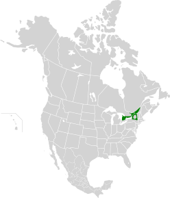
The Eastern Great Lakes lowland forests is a temperate broadleaf and mixed forest ecoregion of North America, as defined by the World Wildlife Fund. It lies mostly in south and eastern Ontario and Quebec in Canada, and Upstate New York and Vermont in the United States.
YouTube Encyclopedic
-
1/3Views:21 8422 874 2635 924
-
Ice Age Lakes between Seattle and the Cascade Range
-
America Before Columbus (Full Documentary)
-
Eastern Gorilla - Fauna Clips
Transcription
This is Interstate 90 crossing Lake Washington on a floating bridge. A legacy of the Ice Age, this lake is far too deep and the lake bottom too soft for a normal bridge. But Glacial Lake Washington was bigger. Three major Ice Age troughs sit between Seattle and the Cascade foothills. And an intricate network of spillways got established with freshwater being transferred from one glacial lake to the next as the Puget Lobe was leaving Seattle almost 17,000 years ago. Let’s head east on I-90 out of Seattle on Interstate 90. Driving from Seattle to North Bend hasn’t always been so easy. Back in the 1920’s, east-bound travelers heading for the Cascade Range took the Sunset Highway, a narrow, two-lane road around the south end of Lake Washington, through Renton and the coal mines, and then on to Issaquah. But in the late 1930’s, a major step forward. Two new tunnels were dug through the sands and clays of Seattle's Mount Baker Ridge. The largest-diameter, soft-earth tunnels in the world at the time. And the world’s first floating bridge built of reinforced concrete. The opening of the Lake Washington Bridge in 1940 meant an efficient escape from downtown Seattle due east out over Lake Washington and Mercer Island. Drivers were now cutting directly across the lay of the land. North-South-trending hills sculpted by the Puget Lobe Ice Sheet during the last gasp of the Ice Age. And between those drumlins, equally impressive glacial troughs. Long ditches carved by rivers of rushing meltwater underneath an ice sheet 3,000 feet thick. The deepest troughs still have water in them. Puget Sound, Lake Washington and Lake Sammamish. 16,900 years ago, when the Puget Lobe was at maximum size the weight of the ice pushed the land down by more than 250 feet. The ice sheet plugged the drainage of the entire Puget Lowland. Rivers from the surrounding mountains, freshwater, were backed up at the ice front. The water was trapped, nowhere to go, unable to drain to the Pacific Ocean. At times, the lake was so large it spilled south into the Chehalis River and got to the Pacific that way. But as the ice began its retreat to the north, the glacial lake scene started to change. Spillways got established. Floods of freshwater being transferred from one trough to the next. Seattle lies at the edge of the deepest trough, but between Seattle and North Bend, 3 separate tongues of ice sat in 3 significant troughs. The ice retreat caused glacial lakes to form where the ice tongues had been. And then the freshwater transfer game from one trough to the next began. Eventally, the ice sheet retreated to Canada, the Strait of Juan de Fuca was reopened, and the waters of the Puget Sound were connected once again with the salty Pacific Ocean. The only fresh water remains of the massive Glacial Lakes of the Ice Age? Today’s Lake Washington and Lake Sammamish. Well that’s a cool story, but this is 'I-90 Rocks'. How much of the story can you see from the freeway? Well for starters, Surely you’ve noticed a huge gravel pit in Issaquah at Exit 17. This is the Lakeside Gravel Pit. Right next to Interstate 90 at Issaquah. It’s an active mine. They’re pulling sand and gravel out of this huge deposit. Much of the sand and gravel was already used to build Interstate 90 a few decades ago. Why is there so much sand and gravel here? It’s an Ice Age deposit. It’s not a moraine though. This is an Ice Age River Delta. Where an Ice Age River flowed into Glacial Lake Sammamish. River deltas form when rivers enter quiet bodies of water. The famous Mississippi River Delta in Louisiana is made of silt. But here in Issaquah, the delta is made of sorted sand and even gravel. A fast-moving Ice Age river. One of those spillways between glacial lakes. In this case, Glacial Lake Snoqualmie overtopping its rim and spilling southwest through surrounding uplands toward Glacial Lake Sammamish. So how can we be sure this a river delta? Couldn’t it be a moraine or something else during the Ice Age? It’s the bedding here. These are inclined beds of sand and gravel. Foreset beds in the guts of this river delta. Here’s how it works. Ice Age river coming into Glacial Lake Sammamish. The river is bringing sand and gravel. But the sand and gravel is being dumped as the river is going into the lake. The speed of the river is dropping to nothing. Each new batch of sand and gravel is getting dumped down the face of this delta underwater. Big avalanches of sand and gravel. And therefore, the delta continues to grow. Continues to build out into the lake. And the height of the delta is the height of Glacial Lake Sammamish long ago. Up on top of the delta, there’s a nice flat bench. That’s the old shoreline of Glacial Lake Sammamish. That’s Lake Sammamish today. During the Ice Age, Lake Sammamish was up to here. This was the lake level. Beachfront property at that lake during the Ice Age right here. Wood fragments from the bottom of the delta have been dated at 15,500 years old. In 1991, a 14,600 year old log was found near the top of the delta. So this gravel deposit took about 1,000 years to build, when Ice Age lakes ruled here. These guys won’t be running out of gravel anytime soon. The entire Tradition Plateau is one big Ice Age River Delta. One of many Ice Age River Deltas that rim the Puget Lowland. The elevation of the delta tops are consistently 120 feet above today’s lakes. At the crest of Eastgate, look east across the Lake Sammamish basin to see the high water mark of Glacial Lake Sammamish. I-90 climbs up two major Ice Age spillways. Heading east at Exit 11, you know the climb. That’s a spillway. Water spilling west from Glacial Lake Sammamish down into Glacial Lake Washington. And the freeway climb after passing the gravel pit and leaving Issaquah? Another spillway. This one from Glacial Lake Snoqualmie down into Glacial Lake Sammamish. Approaching the base of the Cascade Range, bedrock outcrops begin appearing along I-90, and we arrive in the North Bend area. From the top of Rattlesnake Ridge, terrific views of Mt Si and the three forks of the Snoqualmie River converge here. Snoqualmie Valley flooding is still a problem at times. And where the river cascades over ancient volcanic bedrock, gorgeous Snoqualmie Falls is just a few miles from I-90. At the foot of Mount Si, one more significant Ice Age landmark of the Puget Lowland. This ridge that looms over I-90 is important. It’s a glacial moraine, composed of poorly-sorted loose rocks that formed at the edge of a glacier. But which glacier? Ice that flowed down I-90 from Snoqualmie Pass? Or the ice sheet that pushed over Seattle from British Columbia? Dig into the moraine and you'll find rocks from Canada. Not rocks from the Cascades. The Puget Lobe, the same ice sheet that filled much of the Puget Lowland, crept way over here to North Bend. Pushed its way up this valley. And the Grouse Ridge Moraine marks the eastern edge of the ice sheet. But there’s more here than just a moraine. This is another pit. Another active mine using Ice Age rock. But how is this pit different than back in Issaquah? Remember, in the pit in Issaquah we had bedded deposits. Layered foreset beds. An Ice Age river going into a Glacial Lake. This is different. Here at North Bend, we’re at the edge of the Puget Lobe. Along the ice margin. We don’t have those sloping beds. The beds are horizontal. They’re sorted. And there’s also huge glacial erratics all through this deposit. It’s kind of a pain in the neck for the miners to get this sediment out. To work around these huge boulders. Specifically, this is a moraine and outwash complex. And the surface of the outwash is beautifully flat. So coming away from this morainal ridge, we have this beautiful, flat bench. The outwash of Grouse Ridge. Within, all of these rocks from Canada. Not from the Cascades. The Puget Lobe, many times during the Ice Age, blocked Cascade rivers draining the mountains. So we had glacial lakes ponded against the outwash. Rivers bringing sorted rocks from both directions, off of the ice, and also down from the Cascades. The glacial deposits here clearly state that at the end of the Ice Age, the Puget Lobe and the Cascade mountain glaciers were not in snyc. During the last ice sheet advance, alpine glaciers in the Cascades were already retreating back into the mountains. So the I-90 drive from Seattle to North Bend has tons of Ice Age geology. But there’s another story here that goes back even further into our past, and is likely part of our future. The Seattle Fault, a significant east-west crack in the bedrock, runs right beneath the freeway here. The bedrock layers have been vertically offset by thousands of feet. The Seattle Fault has generated hundreds of earthquakes. The fault is responsible for at least 4 magnitude 7 earthquakes in the past 2,500 years. And there is concern for the future. Plate tectonic forces responsible for past Seattle Fault earthquakes continue to squeeze the crust. The most recent quake caused the bedrock south of the fault to jump up suddenly 21 feet about 1,100 years ago. Between Bellevue and Issaquah, have you ever noticed how the freeway runs along a boundary with ridges on the right and lowlands on the left? Earthquakes on the Seattle Fault created this. Each quake on the fault lifted the Issaquah Alps a little higher and dropped the basin a little lower. The hard bedrock on display south of I-90 includes 30 million-year-old volcanic rocks and siltstones of the Blakely Formation. North of I-90, the bedrock is buried by thousands of feet of soft sediment that is prone to seismic shaking. In Bellevue, I-90 crosses Mercer Slough. 1000 feet of very soft peat soils. Earthquake ground-shaking is expected here. In response, the Washington State Department of Transportation has been seismically retrofitting this stretch of I-90. Overpass columns have been reinforced with steel jackets. And cross beams under the freeway have been secured with fixed blocks of concrete. Engineers and geologists working together to help prepare us for the future. How can we be sure there was an earthquake 900 AD on the Seattle Fault? All sorts of different kinds of evidence point to the same conclusion. In the bottom of Lake Washington, there’s a dense forest that’s in the lake. Landslides went into the lake. Brought the tress with them. The trees have been dated. 900 AD. A buried log has been found at West Point, north of Seattle. Discovery Park. The log sits in sand. The sand’s been interpreted as a tsunami generated by the 900 AD earthquake. Charcoal from bogs on Bainbridge Island. Tree rings from trees that were killed by rock avalanches on the Olympic Peninsula. Plus, it’s not just the Seattle Fault. The Tacoma Fault and the Saddle Mountain Fault over by Hood Canal all talk about a 900 AD earthquake Shallow levels in the crust in the Puget Sound. Also at the bottom of Lake Washington, old wooden coal cars sitting upright on the lake bottom. Still loaded with coal. What happened here? In January of 1875, a barge containing 18 coal cars was rounding the northern tip of Mercer Island when strong winds tipped the barge and sent the cars plunging to the bottom of the lake. The coal came from 40 to 50 million-year-old sedimentary rock layers below the Blakely Formation in the Issaquah Alps. The bedrock in the uplifted side of the Seattle Fault. Newcastle, once the second largest city in King County, produced more than 200,000 tons of coal annually at its peak in the 1880’s. To bring the coal from the Newcastle mines to Seattle, the coal was loaded into wooden cars, and sent on rails to the eastern shore of Lake Washington. The cars were barged across the lake to the western shore near present-day Husky Stadium. Unload the barges, more rails and then another barge across Lake Union and through Seattle to the docks. By then, the coal had been handled 11 different times. The coal was regularly shipped as far south as San Francisco, California. Seattle provided 22 percent of the coal produced on the Pacific Coast at the time. With coal, Seattle was able to stand out from the other Puget Sound towns that relied mostly on lumber. Today’s Issaquah Alps are very popular areas for Seattle hikers and bikers. But there’s a geologic reason these uplands have very few condos, malls, and housing developments. Cougar, Squak, and Tiger Mountains are riddled with old coal mines. More than 50 mines, many multi-storied, are now sealed underground for safety reasons. The mine shafts, now filled with groundwater, have rotting timber supports. Development has not been allowed above many of the old mines because of the danger. Coal mining in the Seattle area. An important, often forgotten, chapter between Seattle and North Bend. Well we made it to North Bend. Seattle to North Bend. Through all of that Ice Age geology and the Seattle Fault. Let’s head up into the Cascades for our next episode. Up this glacial valley. Up and over Snoqualmie Pass. And look at the Cascade geology. That’s next up. Thanks for watching this one. Onward to the east we go.
Setting
This area includes much of northern New York state (save for the Adirondacks), western Vermont, the Saint Lawrence Lowlands in southern Quebec and most of southern Ontario between Lake Ontario and Georgian Bay on Lake Huron. The region includes the Frontenac Axis, the Niagara Escarpment up to Manitoulin Island on Lake Huron, and Lake Simcoe. Meanwhile, the forests south of Lake Ontario are classified as the Southern Great Lakes forests ecoregion and in Canada the higher elevations of the Canadian Appalachian Mountains and the Laurentian Mountains constitute the Eastern Canadian forests.[2]
This region has warm summers and cold, snowy winters.
Flora
This ecoregion is a transition area between the taiga to the north and the temperate deciduous forest to the south and thus contains a variety of habitats including freshwater marshes, dunes, bogs, fens, and hardwood and conifer swamps. Trees of the woodland include eastern hemlock, Eastern white pine, Red pine, White spruce, Black spruce, Balsam fir, and hardwoods White oak, Northern red oak, American beech, Sugar maple, Yellow birch, Paper birch and Quaking aspen. Particular areas include the oak/pitch pine mix of the Albany Pine Bush, areas of dry rocky alvar plain, and the white cedars of the Niagara Escarpment.
Fauna
The Eastern Great Lakes lowland forests are very rich in wildlife. Birds include cardinals, downy woodpecker, wood duck and eastern screech owl. Large mammals including Canada lynx (Lynx canadensis), cougar (Puma concolor), caribou (Rangifer tarandus), wolverine (Gulo gulo), elk (Cervus canadensis) and eastern wolf (Canis lycaon) have been completely extirpated from this ecoregion; remaining mammals include white-tailed deer (Odocoileus virginianus), American black bear (Ursus americanus), coyote (Canis latrans), moose (Alces alces), snowshoe hare (Lepus americanus), eastern chipmunk (Tamias striatus), bobcat (Lynx rufus), American red squirrel (Tamiasciurus hudsonicus) and eastern gray squirrel (Sciurus carolinensis).
Threats and preservation
The Saint Lawrence River is one of the most polluted in the world[citation needed] and these surrounding forests are vulnerable to clearance for agriculture and urban development including the cities of Montreal, Ottawa, Quebec City and suburbs of Toronto, Syracuse and Albany, New York. Less than 5% of natural forest remains intact. The fragmented blocks of remaining habitat include: the eastern end of Lake Ontario; Missisquoi National Wildlife Refuge in Vermont; the Chaumont Barrens, Rome Sand Plains, the Albany Pine Bush and the proposed Split Rock Wildway in New York; Bruce Peninsula (the barrier between Georgian Bay and the main section of Lake Huron), Alfred Bog, Luther Marsh, the Ganaraska Forest and Carden Plain in Ontario; and Mont Saint-Hilaire, Lac Saint-François National Wildlife Area and Cap Tourmente National Wildlife Areas in Quebec.
See also
References and external links
- ^ a b c d Hoekstra, J. M.; Molnar, J. L.; Jennings, M.; Revenga, C.; Spalding, M. D.; Boucher, T. M.; Robertson, J. C.; Heibel, T. J.; Ellison, K. (2010). Molnar, J. L. (ed.). The Atlas of Global Conservation: Changes, Challenges, and Opportunities to Make a Difference. University of California Press. ISBN 978-0-520-26256-0.
- ^ a b "Eastern Great Lakes lowland forests | Ecoregions | WWF". World Wildlife Fund. Retrieved 2020-11-13.
- "Eastern Great Lakes Lowland Forests". Terrestrial Ecoregions. World Wildlife Fund.
- World Wildlife Fund, ed. (2001). "Eastern Great Lakes Lowland Forests". WildWorld Ecoregion Profile. National Geographic Society. Archived from the original on 2010-03-08.