
| East Fork High Rock Canyon | |
|---|---|
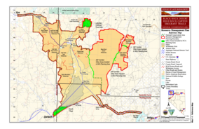 BLM map of the Black Rock-High Rock NCA and 10 wilderness areas including East Fork High Rock Canyon Wilderness | |
| Location | Black Rock Desert, Nevada, United States |
| Coordinates | 41°25′55.631″N 119°21′21.710″W / 41.43211972°N 119.35603056°W |
| Elevation | 1,738 m (5,702 ft) |
| Established | 2000 |
| Operator | Bureau of Land Management |


The East Fork High Rock Canyon Wilderness is a U S Wilderness Area in Nevada under the Bureau of Land Management. It is located on the northeast side of High Rock Canyon but does not include the 4x4 trail inside High Rock Canyon nor a 4x4 trail to the Yellow Hills.[2][3]
YouTube Encyclopedic
-
1/5Views:17 4233 4281 8995732 559
-
Fly fishing for golden trout in Wyoming.
-
East Fork Jemez NM
-
Las Conchas Trail
-
East Fork Fire Timelapse from the Mirror Lake Highway
-
White Mountain Special [Part 2] -- Big Lake & West Fork
Transcription
See also
References
- ^ Protected Planet Website- Retrieved April 13, 2023
- ^ a b "East Fork High Rock Canyon Wilderness". Geographic Names Information System. United States Geological Survey, United States Department of the Interior. Retrieved 2009-05-04.
- ^ "BLM Black Rock Desert-High Rock Canyon Emigrant Trails National Conservation Area". Bureau of Land Management. Archived from the original on 2007-07-03. Retrieved 2007-12-30.
External links
- East Fork High Rock Canyon Wilderness page at Wilderness.net
- U.S. Geological Survey Map at the U.S. Geological Survey Map Website. Retrieved April 13, 2023.

| International | |
|---|---|
| National | |
This article related to a protected area in Nevada is a stub. You can help Wikipedia by expanding it. |
This Washoe County, Nevada state location article is a stub. You can help Wikipedia by expanding it. |
This Humboldt County, Nevada state location article is a stub. You can help Wikipedia by expanding it. |