
Eastern Equatoria | |
|---|---|
| Eastern Equatoria State | |
 Flag  Seal | |
 Location in South Sudan. | |
| Coordinates: 04°45′N 33°11′E / 4.750°N 33.183°E | |
| Country | |
| Region | Equatoria |
| No. of counties: | 8 |
| Capital | Torit |
| Government | |
| • Type | Government |
| • Governor | Louis Lobong Lojore |
| Area | |
| • Total | 73,472.01 km2 (28,367.70 sq mi) |
| Population (2017 estimate[1]) | |
| • Total | 1,393,765 |
| • Density | 19/km2 (49/sq mi) |
| Time zone | UTC+2 (CAT) |
| HDI (2021) | 0.371[2] low · 5th of 10 |
Eastern Equatoria is a state in South Sudan. It has an area of 73,472 km2.[3] The capital City is Torit. On October 1, 1972, the state was divided into Imatong and Namorunyang states and was re-established by a peace agreement signed on 22 February 2020.[4]
Louis Lobong Lojore is the current governor of Eastern Equatoria.
YouTube Encyclopedic
-
1/2Views:7 0418 171
-
LOFIRI (Langairo) 16.02.2013
-
LOFIRI (LONGAIRO)
Transcription
Geography
The state shares international borders with Uganda in the south, with Kenya in the south-east and with Ethiopia in the north-east. Domestically, it is bordered by Central Equatoria in the west and Jonglei in the north. The Ilemi Triangle in the east, between Eastern Equatoria and Lake Turkana, is or has been disputed among all three abutting states (South Sudan, Kenya and Ethiopia).
Population

The state had 906,126 people in 2008 (32/sq mi). Eastern Equatoria state was home to several different ethnic groups. The Toposa, Jiye/Jie and Nyangathom live in the Kapeota counties in the east of the state. The Didinga, Dodoth and Boya live in Budi county around Chukudum. Further west, Lopa, Torit and Ikwoto counties are inhabited by the Ketebo, Otuho, Mokoyi Lopit, Lango, Pari, and Tenet people who inhabit a portion of the lopit hills after they split from Didinga and Murle early in the 19th century and Lokoya of Lowoi. The Acholi, Madi, Iwire and Ofiriha people live in the westernmost Magwi county.[5]
Most of the inhabitants of Eastern Equatoria live by subsistence farming, and also raise cattle, sheep and goats. Some of the crops are sold, while most are consumed locally. The Didinga Hills in Budi county have rich and fertile soil that is used for cultivation of tobacco, potatoes, maize, and Dura.[5]
Government
The executive head of the State was the Governor, who was elected. The Governor was appointing ministers, advisors, and the Executive Directors to the Counties. The Counties in turn, were ruled by the democratically elected Local Government Councils headed by the County Commissioner [6] The state legislature was elected, with the first elections being held in April 2010.
Administrative divisions
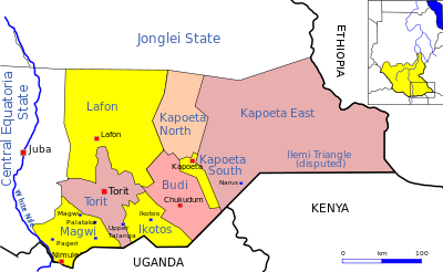
Eastern Equatoria, like other states in South Sudan, was sub-divided into counties. These were further divided into Payams, then Bomas. Each county was headed by a County Commissioner, elected by the people of a County as the head of the local government in the County.
Counties were originally larger, but were subdivided in part to ensure that the different communities have full representation. Thus Torit County was subdivided into Torit, Lopa and Ikwotos counties, and Greater Kapoeta was divided into Budi County and Kapoeta county, which in turn was divided into Kapoeta North, South and East counties.
Counties as of 2020 were:
- Budi County
- Ikotos County
- Kapoeta East County
- Kapoeta North County
- Kapoeta South County
- Lafon County
- Magwi County
- Torit County
Health
As of 2014[update], this was one of the last areas in the world where cases of Guinea worm disease are found, with twelve of the 17 reported cases occurring "in one small pocket of Eastern Equatoria State," according to NPR.[7]
Governors
| Tenure | Governor |
|---|---|
| Feb 1994 - Jun 1994 | Caesar Paia |
| Jun 1994 - Nov 1994 | Marboz Konda |
| Jun 1994 - Dec 1997 | Caesar Paia |
| Dec 1997 - Jan 2000 | Abdullah Amiri |
| Jan 2000 - Feb 2001 | Abdullah Allajabo |
| Feb 2001 - 2005 | Caesar Baya Lolaya |
| 18 Jul 2005 - 30 Sep 2005 | Daniel Awit Akot (acting) |
| 30 Sep 2005 - 24 Feb 2010 | Aloisio Emor Ojetuk |
| 24 Feb 2010 - 20 May 2010 | Johnson Juma Okot |
| 20 May 2010 - 9 Jul 2011 | Louis Lobong |
| 9 Jul 2011 — 9 Jul 2019 | Johnson Juma Okot |
| Jul 2019 — May 2020 | Louis Lobong Lojore |
| Jun 2020 - Present | Louis Lobong Lojore |
Climate Change
See also
References
- ^ "South Sudan: States and counties". www.citypopulation.de. Retrieved 2024-02-14.
- ^ "Sub-national HDI - Area Database - Global Data Lab". hdi.globaldatalab.org. Retrieved 2020-04-18.
- ^ "South Sudan at GeoHive". Archived from the original on 2013-08-27. Retrieved 2013-12-12.
- ^ "After 6 years of war, will peace finally come to South Sudan?".
- ^ a b "Focus On South: Facts About Eastern Equatoria State". Sudan Vision Daily. Archived from the original on 2011-09-28. Retrieved 2011-07-07.
- ^ Local Government Bill 2009
- ^ Doucleff, Michaeleen (2014-07-08). "Going, Going, Almost Gone: A Worm Verges On Extinction". NPR : Goats and Soda. Retrieved 2014-07-09.
External links
| Counties |  | |
|---|---|---|
| Principal towns | ||
| Airports | ||
| Rivers | ||
| Mountains | ||
| Communities | ||
| Bahr el Ghazal |
| ||||
|---|---|---|---|---|---|
| Equatoria |
| ||||
| Greater Upper Nile |
| ||||