To install click the Add extension button. That's it.
The source code for the WIKI 2 extension is being checked by specialists of the Mozilla Foundation, Google, and Apple. You could also do it yourself at any point in time.
How to transfigure the Wikipedia
Would you like Wikipedia to always look as professional and up-to-date? We have created a browser extension. It will enhance any encyclopedic page you visit with the magic of the WIKI 2 technology.
Try it — you can delete it anytime.
Install in 5 seconds
Yep, but later
4,5
Kelly Slayton
Congratulations on this excellent venture… what a great idea!
Alexander Grigorievskiy
I use WIKI 2 every day and almost forgot how the original Wikipedia looks like.
Live Statistics
English Articles
Improved in 24 Hours
Added in 24 Hours
What we do. Every page goes through several hundred of perfecting techniques; in live mode. Quite the same Wikipedia. Just better.
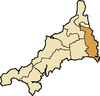
East and West (Wivelshire) must have originally had a Cornish name but it is not recorded. The name of nearby Lostwithiel has the second element gwydhyow[1] meaning 'trees'; wivel may also be from the Anglo-Saxon personal name Wifel.[2] There are also Anglican deaneries by the same names, but the modern boundaries do not correspond exactly. The area must have formed one hundred originally but had already been divided into two before the Norman Conquest: they are grouped in Domesday under the head manors of Rillaton (East) and Fawton (West). The Cornish names are Ryslegh (East) and Fawy (West).[3][4]
However the suggestion that 'the area must have formed one hundred originally' is disputed by the noted Cornish historian, the Rev. W. M. M. Picken, who believes the names to be derived from the Saxon twi-feald-scir, meaning 'two-fold shire.' The 'invariable prefixing of the words East or West ... explains what has happened to the initial letter t' (A Medieval Cornish Miscellany, by W. M. M. Picken, edited by O. J. Padel, Chichester, 2000.)
^Thomas, Charles (1964) "Settlement History in Early Cornwall: I; the antiquity of the hundreds" in: Cornish Archaeology; 3. St Ives: Cornwall Archaeological Society, pp. 70-79)