
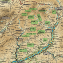
The Dyfi hills (sometimes anglicised to Dovey hills) are a range situated in the southernmost area of Snowdonia, bounded by the River Dyfi on the east and south sides, by the Afon Dulas on the west and the Afon Cerist to the north.[1] They lie to the west of the Aran Fawddwy range, north-east of the Tarren y Gesail range and are a subgroup of the Cadair Idris group.
The highest peaks of the Dyfi hills are Maesglase (2,218 feet (676 m)), Waun-oer (2,200 feet (670 m)) and Cribin Fawr (2,162 feet (659 m)) which lie at the north of the range. Further south the peaks are lower and the hills more gently rounded.
YouTube Encyclopedic
-
1/2Views:4301 454
-
The Snowdonian - the 11 mountain areas of Snowdonia
-
Bivvying On Glyder Fach In Snowdonia – Will's World
Transcription
Slate quarrying
Two major veins of commercial quality slate run through the Dyfi hills, from Aberllefenni in the west, to Dinas Mawddwy in the north-east. Several commercial quarries worked these veins during the 19th and the first half of the 20th centuries. Major quarries in the area include Ratgoed on Mynydd Llwydiarth and Cymerau on Mynydd Cymerau in the west; Hendre Ddu on Mynydd Hendre-ddu, Gartheiniog on Mynydd Gartheiniog in the centre of the hills; and Minllyn on Foel Dinas just south of Dinas Mawddwy.[2]
Forestry

The majority of the area of the Dyfi Hills was planted with forests by the Forestry Commission. Planting started in 1926, and huge areas of land were purchased between the Wars and into the 1950s and 1960s. The trees planted were mainly Sitka Spruce and Japanese Larch, though a large number of other species were also tried. The trees are regularly felled for commercial use and replanted.[3] This forested area forms the major part of the Dyfi Forest.[4][5]
Rallying
They were used as a special stage during the 2013 Wales Rally GB.
References
- ^ Steve Plant (7 May 2014). A Wander Around the Coast of Wales. Fast-Print Publishing. pp. 128–. ISBN 978-1-78035-761-4.
- ^ Richards, Alun John (1999). The Slate Regions of North and Mid Wales and Their Railways. Gwasg Carreg Gwalch. ISBN 978-0-86381-552-2.
- ^ Best, F. C.; Hampson, J. R. (1961). "Forestry in West Central Wales". Forestry (34): 1–13. CiteSeerX 10.1.1.835.5754.
- ^ Carl I Cater; Brian Garrod; Tiffany Low (1 October 2015). The Encyclopedia of Sustainable Tourism. CABI. pp. 338–. ISBN 978-1-78064-143-0.
- ^ Herbert Leeson Edlin (1 January 1975). Cambrian forests. H.M.S.O.
This Gwynedd location article is a stub. You can help Wikipedia by expanding it. |