
Dursunbey | |
|---|---|
District and municipality | |
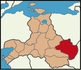 Map showing Dursunbey District in Balıkesir Province | |
 Dursunbey Location in Turkey  Dursunbey Dursunbey (Marmara) | |
| Coordinates: 39°35′16″N 28°37′39″E / 39.587778°N 28.6275°E | |
| Country | Turkey |
| Province | Balıkesir |
| Government | |
| • Mayor | Ramazan Bahçavan (AKP) |
| Area | 1,719 km2 (664 sq mi) |
| Elevation | 670 m (2,200 ft) |
| Population (2022)[1] | 33,333 |
| • Density | 19/km2 (50/sq mi) |
| Time zone | TRT (UTC+3) |
| Postal code | 10800 |
| Area code | 0266 |
| Website | www |
Dursunbey, formerly Balat, is a municipality and district of Balıkesir Province, Turkey.[2] Its area is 1,719 km2,[3] and its population is 33,333 (2022).[1] The mayor is Ramazan Bahçavan (AKP). Dursunbey is noted for its wood and apples.
YouTube Encyclopedic
-
1/3Views:2 5416 5475 683
-
Tuğçe İle Pazarın Sesi - 10.Bölüm - Dursunbey Pazarı
-
Dursunbey'de Dolu Felaketi
-
Dere Tepe Balıkesir - Dursunbey - 1.Bölüm - 2.Parça
Transcription
Composition
There are 111 neighbourhoods in Dursunbey District:[4]
- 3 Eylül
- Adaören
- Akbaşlar
- Akçagüney
- Akyayla
- Alaçam
- Alagüney
- Arıklar
- Aşağımusalar
- Aşağıyağcılar
- Ayvacık
- Aziziye
- Bayıryüzügüney
- Beyce
- Beyel
- Boyalıca
- Bozyokuş
- Büyükakçaalan
- Çakırca
- Çakmak
- Çaltıcak
- Çamharman
- Çamköy
- Çanakçı
- Çatalçam
- Cebeci
- Çelikler
- Çiftçi
- Çınarköy
- Dada
- Değirmenciler
- Delice
- Demirciler
- Dereköy
- Dodurga
- Doğancılar
- Durabeyler
- Ericek
- Ferah
- Gazellidere
- Göbül
- Gökçedağ
- Gökçepınar
- Gölcük
- Güğü
- Gürleyen
- Hacıahmetpınarı
- Hacılar
- Hamzacık
- Hasanlar
- Hindikler
- Hondular
- Hopanlar
- İrfaniye
- Işıklar
- İsmailler
- İstasyon
- Karagöz
- Karakaya
- Karamanlar
- Karapınar
- Kardeşler
- Karyağmaz
- Kavacık
- Kavakköy
- Kazimiye
- Kireç
- Kızılcadere
- Kızılöz
- Küçükakçaalan
- Küçükler
- Kumlu
- Kurtlar
- Kuzköy
- Mahmudiye
- Mahmutça
- Meydançayırı
- Mıcırlar
- Mollaoğlu
- Naipler
- Odaköy
- Örenköy
- Osmaniye
- Poyracık
- Ramazanlar
- Reşadiye
- Resüller
- Şabanlar
- Saçayak
- Sağırlar
- Sakızköy
- Sarısipahiler
- Sarnıçköy
- Sebiller
- Selimağa
- Şenköy
- Sinderler
- Süleler
- Tafak
- Taşkesiği
- Taşpınar
- Tepeköy
- Tezlik
- Turnacık
- Umurlar
- Vakıf
- Veliler
- Yassıören
- Yukarımusalar
- Yukarıyağcılar
- Yunuslar
Climate
Dursunbey has a hot-summer Mediterranean climate (Köppen: Csa),[5] with hot, dry summers, and chilly, moderately snowy winters.[6]
| Climate data for Dursunbey (1991–2020) | |||||||||||||
|---|---|---|---|---|---|---|---|---|---|---|---|---|---|
| Month | Jan | Feb | Mar | Apr | May | Jun | Jul | Aug | Sep | Oct | Nov | Dec | Year |
| Mean daily maximum °C (°F) | 7.4 (45.3) |
9.2 (48.6) |
12.8 (55.0) |
17.4 (63.3) |
22.7 (72.9) |
27.2 (81.0) |
30.3 (86.5) |
30.8 (87.4) |
26.5 (79.7) |
20.9 (69.6) |
14.6 (58.3) |
9.0 (48.2) |
19.1 (66.4) |
| Daily mean °C (°F) | 2.7 (36.9) |
3.9 (39.0) |
6.6 (43.9) |
10.9 (51.6) |
15.8 (60.4) |
19.9 (67.8) |
22.5 (72.5) |
22.5 (72.5) |
18.6 (65.5) |
13.9 (57.0) |
8.5 (47.3) |
4.4 (39.9) |
12.6 (54.7) |
| Mean daily minimum °C (°F) | −0.7 (30.7) |
0.0 (32.0) |
2.0 (35.6) |
5.5 (41.9) |
9.8 (49.6) |
13.4 (56.1) |
15.6 (60.1) |
15.7 (60.3) |
12.3 (54.1) |
8.8 (47.8) |
4.2 (39.6) |
1.1 (34.0) |
7.3 (45.1) |
| Average precipitation mm (inches) | 73.04 (2.88) |
63.03 (2.48) |
57.3 (2.26) |
58.95 (2.32) |
45.71 (1.80) |
37.08 (1.46) |
10.53 (0.41) |
11.05 (0.44) |
25.94 (1.02) |
48.27 (1.90) |
58.4 (2.30) |
70.69 (2.78) |
559.99 (22.05) |
| Average precipitation days (≥ 1.0 mm) | 8.9 | 8.1 | 8.0 | 7.1 | 6.7 | 4.7 | 1.8 | 2.1 | 3.7 | 5.8 | 6.7 | 9.3 | 72.9 |
| Average relative humidity (%) | 75.9 | 72.7 | 68.6 | 65.2 | 64.3 | 61.5 | 58.4 | 59.8 | 62.1 | 69.2 | 72.2 | 76.3 | 67.2 |
| Source: NOAA[7] | |||||||||||||
References
- ^ a b "Address-based population registration system (ADNKS) results dated 31 December 2022, Favorite Reports" (XLS). TÜİK. Retrieved 22 May 2023.
- ^ Büyükşehir İlçe Belediyesi, Turkey Civil Administration Departments Inventory. Retrieved 8 June 2023.
- ^ "İl ve İlçe Yüz ölçümleri". General Directorate of Mapping. Retrieved 22 May 2023.
- ^ Mahalle, Turkey Civil Administration Departments Inventory. Retrieved 22 May 2023.
- ^ "Table 1 Overview of the Köppen-Geiger climate classes including the defining criteria". Nature: Scientific Data.
- ^ "Kar Örtülü Gün Sayısı" (PDF). MGM.
- ^ "World Meteorological Organization Climate Normals for 1991-2020 — Dursunbey". National Oceanic and Atmospheric Administration. Retrieved January 14, 2024.
External links
Dursunbey in Balıkesir Province of Turkey | |||||||||||||||||||||||||||
|---|---|---|---|---|---|---|---|---|---|---|---|---|---|---|---|---|---|---|---|---|---|---|---|---|---|---|---|
| Districts |   | ||||||||||||||||||||||||||
|
Metropolitan municipalities are bolded. | |||||||||||||||||||||||||||
| International | |
|---|---|
| National | |
| Other | |
This geographical article about a location in Balıkesir Province, Turkey is a stub. You can help Wikipedia by expanding it. |