
Dodson, Montana | |
|---|---|
 Location of Dodson, Montana | |
 Dodson, Montana Location in the United States | |
| Coordinates: 48°23′43″N 108°14′50″W / 48.39528°N 108.24722°W | |
| Country | United States |
| State | Montana |
| County | Phillips |
| Area | |
| • Total | 0.17 sq mi (0.43 km2) |
| • Land | 0.17 sq mi (0.43 km2) |
| • Water | 0.00 sq mi (0.00 km2) |
| Elevation | 2,284 ft (696 m) |
| Population (2020) | |
| • Total | 125 |
| • Density | 753.01/sq mi (290.51/km2) |
| Time zone | UTC-7 (Mountain (MST)) |
| • Summer (DST) | UTC-6 (MDT) |
| ZIP code | 59524 |
| Area code | 406 |
| FIPS code | 30-21025 |
| GNIS feature ID | 2412438[2] |
Dodson is a town in Phillips County, Montana, United States. The population was 125 at the 2020 census.[3]
History
Dodson was named after a merchant who operated a trading post and saloon there before the Great Northern Railway came through. The first post office was established in 1891.[4]
Geography
According to the United States Census Bureau, the town has a total area of 0.19 square miles (0.49 km2), all land.[5]
Climate
According to the Köppen Climate Classification system, Dodson has a semi-arid climate, abbreviated "BSk" on climate maps.[6]
Demographics
| Census | Pop. | Note | %± |
|---|---|---|---|
| 1920 | 365 | — | |
| 1930 | 249 | −31.8% | |
| 1940 | 397 | 59.4% | |
| 1950 | 330 | −16.9% | |
| 1960 | 313 | −5.2% | |
| 1970 | 196 | −37.4% | |
| 1980 | 158 | −19.4% | |
| 1990 | 137 | −13.3% | |
| 2000 | 122 | −10.9% | |
| 2010 | 124 | 1.6% | |
| 2020 | 125 | 0.8% | |
| U.S. Decennial Census[7][3] | |||
2010 census
As of the census[8] of 2010, there were 124 people, 49 households, and 32 families residing in the town. The population density was 652.6 inhabitants per square mile (252.0/km2). There were 71 housing units at an average density of 373.7 per square mile (144.3/km2). The racial makeup of the town was 41.9% White, 49.2% Native American, 2.4% from other races, and 6.5% from two or more races. Hispanic or Latino of any race were 6.5% of the population.
There were 49 households, of which 38.8% had children under the age of 18 living with them, 40.8% were married couples living together, 16.3% had a female householder with no husband present, 8.2% had a male householder with no wife present, and 34.7% were non-families. 32.7% of all households were made up of individuals, and 12.3% had someone living alone who was 65 years of age or older. The average household size was 2.53 and the average family size was 3.16.
The median age in the town was 35.5 years. 32.3% of residents were under the age of 18; 6.4% were between the ages of 18 and 24; 21.7% were from 25 to 44; 15.2% were from 45 to 64; and 24.2% were 65 years of age or older. The gender makeup of the town was 54.8% male and 45.2% female.
2000 census
As of the census[9] of 2000, there were 122 people, 49 households, and 34 families residing in the town. The population density was 648.4 inhabitants per square mile (250.3/km2). There were 66 housing units at an average density of 350.8 per square mile (135.4/km2). The racial makeup of the town was 50.00% White, 45.08% Native American, 0.82% Asian, and 4.10% from two or more races. Hispanic or Latino of any race were 2.46% of the population.
There were 49 households, out of which 40.8% had children under the age of 18 living with them, 49.0% were married couples living together, 14.3% had a female householder with no husband present, and 28.6% were non-families. 28.6% of all households were made up of individuals, and 20.4% had someone living alone who was 65 years of age or older. The average household size was 2.49 and the average family size was 2.97.
In the town, the population was spread out, with 33.6% under the age of 18, 4.9% from 18 to 24, 20.5% from 25 to 44, 19.7% from 45 to 64, and 21.3% who were 65 years of age or older. The median age was 39 years. For every 100 females, there were 87.7 males. For every 100 females age 18 and over, there were 76.1 males.
The median income for a household in the town was $19,464, and the median income for a family was $33,750. Males had a median income of $21,250 versus $33,125 for females. The per capita income for the town was $10,187. There were 23.7% of families and 28.9% of the population living below the poverty line, including 44.7% of under eighteens and 11.1% of those over 64.
Education
Dodson School District educates students from kindergarten through 12th grade.[10] Dodson High School's team name is the Coyotes.[11]
Phillips County Library has a branch location in Dodson.[12]
Events
Dodson is the location of the Phillips County Fair, which claims to be the longest-running fair in Montana.[13]
Media
The Phillips County News is a weekly local newspaper.[14] They provide a printed paper as well as news online.
Transportation
Amtrak’s Empire Builder, which operates between Seattle/Portland and Chicago, passes through the town on BNSF tracks, but makes no stop. The nearest station is located in Malta, 18 miles (29 km) to the east.
See also
References
- ^ "ArcGIS REST Services Directory". United States Census Bureau. Retrieved September 5, 2022.
- ^ a b U.S. Geological Survey Geographic Names Information System: Dodson, Montana
- ^ a b "U.S. Census website". United States Census Bureau. Retrieved November 2, 2021.
- ^ VirtualMontana.com
- ^ "US Gazetteer files 2010". United States Census Bureau. Archived from the original on July 2, 2012. Retrieved December 18, 2012.
- ^ Climate Summary for Dodson, Montana
- ^ "Census of Population and Housing". Census.gov. Retrieved June 4, 2015.
- ^ "U.S. Census website". United States Census Bureau. Retrieved December 18, 2012.
- ^ "U.S. Census website". United States Census Bureau. Retrieved January 31, 2008.
- ^ "About Us". Dodson School District. Retrieved April 13, 2021.
- ^ "Member Schools". Montana High School Association. Retrieved April 19, 2021.
- ^ "Phillips County Library". Montana State Library. Retrieved April 13, 2021.
- ^ Phillips County Fair, Phillips County Fair. Accessed June 13, 2009.
- ^ "News". Phillips County News. Retrieved January 2, 2024.
External links
Municipalities and communities of Phillips County, Montana, United States | ||
|---|---|---|
| City | 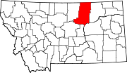 | |
| Towns | ||
| CDPs | ||
| Other communities | ||
| Indian reservations | ||
| Footnotes | ‡This populated place also has portions in an adjacent county or counties | |