
| Dnieper–Bug estuary | |
|---|---|
 Satellite view of the Dnieper–Bug estuary | |
 Dnieper–Bug estuary 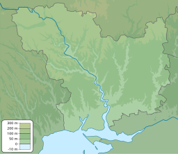 Dnieper–Bug estuary 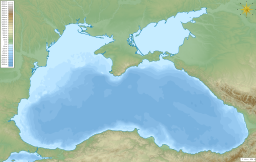 Dnieper–Bug estuary | |
| Location | Ukraine |
| Coordinates | 46°37′N 31°57′E / 46.617°N 31.950°E |
| Type | estuary |
| Primary inflows | Dnieper, Southern Bug |
| Basin countries | Ukraine |
| Max. length | 63 km (39 mi) |
| Max. width | 17 km (11 mi) |
| Surface area | 1,006.3 km2 (388.5 sq mi) |
| Average depth | 4–6 m (13–20 ft) |
| Max. depth | 12 m (39 ft) |
| Settlements | Ochakiv, Mykolaiv |
The Dnieper–Bug estuary (Ukrainian: Дніпровсько-Бузький лиман, romanized: Dniprovsko-Buzkyi lyman), also called the Dniprovska Gulf, is an open estuary, or liman, of two rivers: the Dnieper and the Southern Bug (also called the Boh River). It is located on the northern coast of the Black Sea and is separated from it by the Kinburn Spit and the Cape of Ochakiv.
Description

The estuary includes two parts: the wide Dnieper estuary (55 km long, up to 17 km wide), and the narrower Bug estuary (47 km long, from 5 to 11 km wide). The average depth is 6–7 metres (20–23 ft) and the maximum depth 12 metres (39 ft).
The estuary is important for transport, recreation, and fisheries. Its most important port is Ochakiv.
Historical events
The estuary was a naval battleground in the Russo-Turkish War of 1787–1792. A key event in that war was the Siege of Ochakov, while naval battles – which involved the Russian Dnieper Flotilla,[1] John Paul Jones' deep-water fleet[2][3] and the Ottoman Navy – included the First Battle of the Liman on June 7, 1788 and the Second Battle of the Liman on June 16 and 17.[1][3]

Key landmarks
The ruins of Pontic Olvia are located on the right bank of the Southern Bug (Boh River), right at its mouth.
There is an artificial island which is often mistaken for Berezan Island, but it is actually Pervomaiskyi Island.
References
- ^ a b A. B. Shirokorad, The Russian-Turkish War, cited at "Успехи Лиманской флотилии" [Advance of the Flotilla to the Liman]. Military history of the 2nd half of the 18th century. Retrieved March 4, 2015. (in Russian)
- ^ Morison, Samuel Eliot (1959). John Paul Jones - A Sailor's Biography. Atlantic Monthly Press. pp. 435–439. ISBN 978-1568524658. Retrieved March 4, 2015. (in English)
- ^ a b Martelle, Scott (2014). The Admiral and the Ambassador: One Man's Obsessive Search for the Body of John Paul Jones. Chicago Review Press. pp. 102–106. ISBN 978-1613747308. Retrieved March 4, 2015. (in English)
External links
- Dnipro–Boh Estuary at the Encyclopedia of Ukraine (in Ukrainian)
| International | |
|---|---|
| National | |
| Other | |
This article about a location in Ukraine is a stub. You can help Wikipedia by expanding it. |