
 |
|---|
|
|
| Constitution |
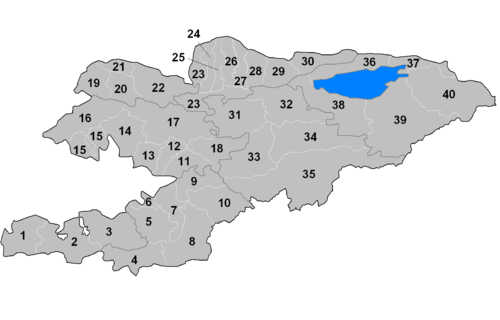
The regions of Kyrgyzstan are divided into districts (raions), administered by government-appointed officials. Rural communities (ayyl aymagy) consisting of up to twenty small settlements have their own elected mayors and councils. The raions are listed below, by region:
YouTube Encyclopedic
-
1/3Views:2 802 36365 58549 246
-
Vietnam Nightlife 2017 - Vlog 143 (bars, cheap beer, girls)
-
7 Facts about Brunei
-
Kenya Mombasa Nightlife
Transcription
North Kyrgyzstan
Bishkek City
The capital city of Bishkek has the status of region[1] and is divided into four districts:[2]
| District | Kyrgyz name | Population (2009) |
|---|---|---|
| Birinchi May | Биринчи май | 171,467 |
| Lenin | Ленин | 198,019 |
| Oktyabr | Октябрь | 238,329 |
| Sverdlov | Свердлов | 214,100 |
Chüy Region
Chüy Region is divided administratively into 8 districts:[2][3]
| District | Kyrgyz name | Capital | Population (2009) | Area (km2) | Density (/km2) | Rural communities |
Towns | Urban-type settlements |
Villages | Number on map |
|---|---|---|---|---|---|---|---|---|---|---|
| Alamüdün | Аламүдүн | Lebedinovka | 147,208 | 1,503 | 98 | 17 | * | * | 50 | 27 |
| Chüy | Чүй | Tokmok | 44,753 | 1,756 | 25.5 | 10 | * | * | 38 | 29 |
| Jayyl | Жайыл | Kara-Balta | 90,348 | 3,435 | 26.3 | 12 | 1 | * | 36 | 24 |
| Kemin | Кемин | Kemin | 41,924 | 3,533 | 11.9 | 11 | 2 | 1 | 34 | 30 |
| Moskva | Москва | Belovodskoye | 83,641 | 2,056 | 40.7 | 12 | * | * | 28 | 25 |
| Panfilov | Панфилов | Kayyngdy | 39,837 | 2,606 | 15.3 | 6 | 1 | * | 20 | 23 |
| Sokuluk | Сокулук | Sokuluk | 158,137 | 2,550 | 62 | 19 | 1 | * | 68 | 26 |
| Ysyk-Ata | Ысык-Ата | Kant | 131,503 | 2,415 | 54.5 | 18 | 1 | * | 56 | 28 |
Issyk-Kul Region
Issyk-Kul Region is divided administratively into 5 districts:[2]
| District | Kyrgyz name | Capital | Population (2009) | Area (km2) | Density (/km2) | Rural communities |
Towns | Urban-type settlements |
Villages | Number on map |
|---|---|---|---|---|---|---|---|---|---|---|
| Ak-Suu | Ак-Суу | Teploklyuchenka | 62,524 | 9,917 | 6.3 | 14 | * | * | 39 | 40 |
| Issyk-Kul | Ысык-Көл | Cholpon-Ata | 74,973 | 3,603 | 20.8 | 12 | 1 | * | 30 | 36 |
| Jeti-Ögüz | Жети-Өгүз | Kyzyl-Suu | 79,328 | 14,499 | 5.5 | 13 | * | * | 47 | 39 |
| Tong | Тоң | Bökönbaev | 48,870 | 7,230 | 6.8 | 9 | * | * | 30 | 38 |
| Tüp | Түп | Tüp | 56,416 | 2,121 | 26.6 | 13 | * | * | 37 | 37 |
Naryn Region
Naryn Region is divided administratively into 5 districts:[2]
| District | Kyrgyz name | Capital | Population (2009) | Area (km2) | Density (/km2) | Rural communities |
Towns | Urban-type settlements |
Villages | Number on map |
|---|---|---|---|---|---|---|---|---|---|---|
| Ak-Talaa | Ак-талаа | Baetov | 30,643 | 7,266 | 4.2 | 13 | * | * | 19 | 33 |
| At-Bashy | Ат-Башы | At-Bashy | 49,238 | 15,354 | 3.2 | 11 | * | * | 18 | 35 |
| Jumgal | Жумгал | Chaek | 40,718 | 4,803 | 8.5 | 13 | * | * | 28 | 31 |
| Kochkor | Кочкор | Kochkor | 58,267 | 5,868 | 9.9 | 11 | * | * | 32 | 32 |
| Naryn | Нарын | Naryn | 44,080 | 10,502 | 4.2 | 15 | 1 | * | 39 | 34 |
Talas Region
Talas Region is divided administratively into 4 districts:[2]
| District | Kyrgyz name | Capital | Population (2009) | Area (km2) | Density (/km2) | Rural communities |
Towns | Urban-type settlements |
Villages | Number on map |
|---|---|---|---|---|---|---|---|---|---|---|
| Bakay-Ata | Бакай-Ата | Bakay-Ata | 44,057 | 2,928 | 15 | 9 | * | * | 19 | 20 |
| Kara-Buura | Кара-Буура | Kyzyl-Adyr | 58,056 | 4,216 | 14 | 10 | * | * | 23 | 19 |
| Manas | Манас | Pokrovka | 32,913 | 1,198 | 27 | 5 | * | * | 22 | 21 |
| Talas | Талас | Manas | 58,867 | 5,051 | 12 | 13 | * | * | 27 | 22 |
South Kyrgyzstan
Batken Region
Batken Region is divided administratively into 3 districts:[2]
| District | Kyrgyz name | Capital | Population (2009) | Area (km2) | Density (/km2) | Rural communities |
Towns | Urban-type settlements |
Villages | Number on map |
|---|---|---|---|---|---|---|---|---|---|---|
| Batken | Баткен | Batken | 69,591 | 5,948 | 11.7 | * | * | * | 42 | 2 |
| Kadamjay | Кадамжай | Kadamjay | 157,597 | 6,146 | 25.6 | * | * | 4 | 103 | 3 |
| Leylek | Лейлек | Isfana | 116,861 | 4,653 | 25.1 | * | 1 | * | 46 | 1 |
Jalal-Abad Region
Jalal-Abad Region is divided administratively into 8 districts:[2]
| District | Kyrgyz name | Capital | Population (2009) | Area (km2) | Density (/km2) | Rural communities |
Towns | Urban-type settlements |
Villages | Number on map |
|---|---|---|---|---|---|---|---|---|---|---|
| Aksy | Аксы | Kerben | 106,049 | 4,578 | 23.2 | * | 1 | * | 68 | 14 |
| Ala-Buka | Ала-Бука | Ala-Buka | 81,488 | 2,976 | 27.4 | * | * | * | 41 | 15 |
| Bazar-Korgon | Базар-Коргон | Bazar-Korgon | 132,051 | 1,965 | 67.2 | * | * | * | 57 | 12 |
| Chatkal | Чаткал | Kanysh-Kyya | 21,154 | 4,608 | 4.6 | * | * | 2 | 9 | 16 |
| Nooken | Ноокен | Masy | 109,687 | 2,336 | 47 | * | 1 | * | 54 | 13 |
| Suzak | Сузак | Suzak | 220,675 | 3,019 | 73.1 | * | 1 | * | 123 | 11 |
| Toguz-Toro | Тогуз-Торо | Kazarman | 21,417 | 3,816 | 5.6 | * | * | * | 13 | 18 |
| Toktogul | Токтогул | Toktogul | 83,479 | 7,815 | 10.7 | * | * | 1 | 44 | 17 |
Osh Region
Osh Region is divided administratively into 7 districts:[2]
| District | Kyrgyz name | Capital | Population (2009) | Area (km2) | Density (/km2) | Rural communities |
Towns | Urban-type settlements |
Villages | Number on map |
|---|---|---|---|---|---|---|---|---|---|---|
| Alay | Алай | Gülchö | 72,170 | 6,821 | 11 | 14 | * | * | 62 | 8 |
| Aravan | Араван | Aravan | 106,134 | 1,340 | 79 | 8 | * | * | 48 | 6 |
| Chong-Alay | Чоң Алай | Daroot-Korgon | 25,039 | 4,857 | 5.2 | 3 | * | * | 22 | 4 |
| Kara-Kulja | Кара-Кулжа | Kara-Kulja | 87,691 | 5,813 | 15 | 12 | * | * | 49 | 10 |
| Kara-Suu | Кара-Суу | Kara-Suu | 348,645 | 3,616 | 96 | 16 | 1 | * | 122 | 7 |
| Nookat | Ноокат | Nookat | 236,455 | 3,179 | 74 | 16 | 1 | * | 75 | 5 |
| Özgön | Өзгөн | Özgön | 228,114 | 3,308 | 69 | 19 | 1 | * | 99 | 9 |
See also
References
- ^ Law on the Status of Bishkek Archived July 21, 2011, at the Wayback Machine, 16 April 1994, article 2 (in Russian). Retrieved on 7 April 2009
- ^ a b c d e f g h "Classification system of territorial units of the Kyrgyz Republic" (in Kyrgyz). National Statistics Committee of the Kyrgyz Republic. May 2021. pp. 98–100.
- ^ The Government of the Chüy Region: The districts of Chüy Oblast Archived August 24, 2007, at the Wayback Machine (in Russian)
External links
- Statoids
- Kyrgyzstan: Regions, districts, district capitals Archived August 2, 2009, at the Wayback Machine